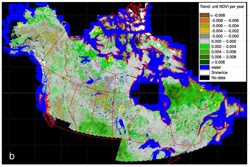
ABoVE: NDVI Trends across Alaska and Canada from Landsat, 1984-2012
Access & Use Information
Downloads & Resources
-
Google Scholar search resultsHTML
Search results for publications that cite this dataset by its DOI.
-
Download this datasetHTML
This link allows direct data access via Earthdata login
-
View documentation related to this datasetHTML
ORNL DAAC Data Set Documentation
-
This dataset's landing pageHTML
Data set Landing Page DOI URL
-
View documentation related to this datasetPDF
ABoVE: Vegetation Greenness Trend from Landsat Imagery, Alaska and Canada,...
-
Get a related visualizationPNG
Figure 1: NDVI trends derived from 30-m Landsat NDVI times series for...
-
The dataset's project home pageHTML
ABoVE project site
-
Landing PageLanding Page
Dates
| Metadata Created Date | December 1, 2022 |
|---|---|
| Metadata Updated Date | December 6, 2023 |
Metadata Source
- Data.json Data.json Metadata
Harvested from NASA Data.json
Graphic Preview

Additional Metadata
| Resource Type | Dataset |
|---|---|
| Metadata Created Date | December 1, 2022 |
| Metadata Updated Date | December 6, 2023 |
| Publisher | ORNL_DAAC |
| Maintainer | |
| Identifier | C2162131333-ORNL_CLOUD |
| Data First Published | 2019-03-14 |
| Language | en-US |
| Data Last Modified | 2023-06-12 |
| Category | ABoVE, geospatial |
| Public Access Level | public |
| Bureau Code | 026:00 |
| Metadata Context | https://project-open-data.cio.gov/v1.1/schema/catalog.jsonld |
| Metadata Catalog ID | https://data.nasa.gov/data.json |
| Schema Version | https://project-open-data.cio.gov/v1.1/schema |
| Catalog Describedby | https://project-open-data.cio.gov/v1.1/schema/catalog.json |
| Citation | Ju, J., and J.G. Masek. 2018. ABoVE: NDVI Trends across Alaska and Canada from Landsat, 1984-2012. ORNL DAAC, Oak Ridge, Tennessee, USA. https://doi.org/10.3334/ORNLDAAC/1576 |
| Graphic Preview Description | Figure 1: NDVI trends derived from 30-m Landsat NDVI times series for 1984-2012 for Canada and Alaska (Ju and Masek, 2016). |
| Graphic Preview File | https://daac.ornl.gov/ABOVE/guides/Vegetation_greenness_trend_Fig1.png |
| Harvest Object Id | aea35974-f8b4-45fb-809e-3cb8c251b6c2 |
| Harvest Source Id | 58f92550-7a01-4f00-b1b2-8dc953bd598f |
| Harvest Source Title | NASA Data.json |
| Homepage URL | https://doi.org/10.3334/ORNLDAAC/1576 |
| Metadata Type | geospatial |
| Old Spatial | -169.97 41.61 -50.17 80.51 |
| Program Code | 026:001 |
| Source Datajson Identifier | True |
| Source Hash | 0d072144633cc52b804f66fa6a47d339e8ac7c1835e1da57831f52bc8c711343 |
| Source Schema Version | 1.1 |
| Spatial | |
| Temporal | 1984-01-01T00:00:00Z/2012-12-31T23:59:59Z |
Didn't find what you're looking for? Suggest a dataset here.

