ABoVE: Lake and Pond Extents in Alaskan Boreal and Tundra Subregions, 2019-2021
Access & Use Information
Downloads & Resources
-
Google Scholar search resultsHTML
Search results for publications that cite this dataset by its DOI.
-
Download this datasetHTML
This link allows direct data access via Earthdata login
-
View documentation related to this datasetHTML
ORNL DAAC Data Set Documentation
-
This dataset's landing pageHTML
Data set Landing Page DOI URL
-
View documentation related to this datasetPDF
ABoVE: Lake and Pond Extents in Alaskan Boreal and Tundra Subregions,...
-
Get a related visualizationPNG
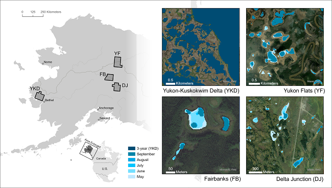
Four subregions of Alaska (left) with example of lakes and ponds derived from...
-
The dataset's project home pageHTML
ABoVE project site
-
Landing PageLanding Page
Dates
| Metadata Created Date | May 30, 2023 |
|---|---|
| Metadata Updated Date | December 6, 2023 |
Metadata Source
- Data.json Data.json Metadata
Harvested from NASA Data.json
Other Data Resources
- Geoplatform Metadata Information
Graphic Preview

Additional Metadata
| Resource Type | Dataset |
|---|---|
| Metadata Created Date | May 30, 2023 |
| Metadata Updated Date | December 6, 2023 |
| Publisher | ORNL_DAAC |
| Maintainer | |
| Identifier | C2612824429-ORNL_CLOUD |
| Data First Published | 2023-02-15 |
| Language | en-US |
| Data Last Modified | 2023-06-12 |
| Category | ABoVE, geospatial |
| Public Access Level | public |
| Bureau Code | 026:00 |
| Metadata Context | https://project-open-data.cio.gov/v1.1/schema/catalog.jsonld |
| Metadata Catalog ID | https://data.nasa.gov/data.json |
| Schema Version | https://project-open-data.cio.gov/v1.1/schema |
| Catalog Describedby | https://project-open-data.cio.gov/v1.1/schema/catalog.json |
| Citation | Mullen, A., J.D. Watts, B.M. Rogers, M.L. Carroll, J.A. Caraballo-Vega, J. Noomah, Z.W. Williams, J.K.Y. Hung, and S. Natali. 2022. ABoVE: Lake and Pond Extents in Alaskan Boreal and Tundra Subregions, 2019-2021. ORNL DAAC, Oak Ridge, Tennessee, USA. https://doi.org/10.3334/ORNLDAAC/2134 |
| Graphic Preview Description | Four subregions of Alaska (left) with example of lakes and ponds derived from PlanetScope imagery (right). Lake and pond extents include monthly climatological composites (May - September) and 3-year composites for 2019-2021. Seasonal dynamics of expansion and contraction for these bodies of water are documented. The inset for the Fairbanks (FB) region shows a close-up of the water extents overlain on sub-meter Esri base map imagery, illustrating the 3-m resolution of the PlanetScope imagery. The Yukon Flats (YF) inset shows variability in surface area of large lakes, which is common in this region. The Delta Junction (DJ) inset shows seasonal changes in the area of small ponds. The Yukon-Kuskokwim Delta (YKD) inset shows the spatial variability of water body areas in this region and is an example of a 3-year composite. |
| Graphic Preview File | https://daac.ornl.gov/ABOVE/guides/Alaska_Lake_Pond_Maps_Fig1.png |
| Harvest Object Id | 79bd7266-d20e-4049-8039-e0e1bbe7daa3 |
| Harvest Source Id | 58f92550-7a01-4f00-b1b2-8dc953bd598f |
| Harvest Source Title | NASA Data.json |
| Homepage URL | https://doi.org/10.3334/ORNLDAAC/2134 |
| Metadata Type | geospatial |
| Old Spatial | -164.4 60.76 -143.84 67.21 |
| Program Code | 026:001 |
| Source Datajson Identifier | True |
| Source Hash | 3d13717d24fbffde3e0e2ce1dec3c96dca657e25618a2b05ff1e06946cd72ccc |
| Source Schema Version | 1.1 |
| Spatial | |
| Temporal | 2019-05-19T00:00:00Z/2021-09-28T23:59:59Z |
Didn't find what you're looking for? Suggest a dataset here.


