ABoVE: Atmospheric Profiles of CO, CO2 and CH4 Concentrations from Arctic-CAP, 2017
Access & Use Information
Downloads & Resources
-
Google Scholar search resultsHTML
Search results for publications that cite this dataset by its DOI.
-
Download this datasetHTML
This link allows direct data access via Earthdata login
-
View documentation related to this datasetHTML
ORNL DAAC Data Set Documentation
-
This dataset's landing pageHTML
Data set Landing Page DOI URL
-
Use OPeNDAP to access the dataset's dataHTML
USE SERVICE API
-
View documentation related to this datasetPDF
ABoVE: Atmospheric Profiles of CO, CO2 and CH4 Concentration, Alaska and...
-
Get a related visualizationPNG
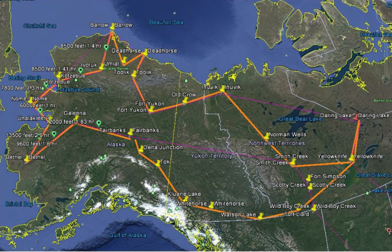
Arctic-CAP flight lines (orange) sample Arctic and boreal regions of Alaska...
-
The dataset's project home pageHTML
ABoVE project site
-
Landing PageLanding Page
Dates
| Metadata Created Date | December 1, 2022 |
|---|---|
| Metadata Updated Date | December 6, 2023 |
Metadata Source
- Data.json Data.json Metadata
Harvested from NASA Data.json
Graphic Preview

Additional Metadata
| Resource Type | Dataset |
|---|---|
| Metadata Created Date | December 1, 2022 |
| Metadata Updated Date | December 6, 2023 |
| Publisher | ORNL_DAAC |
| Maintainer | |
| Identifier | C2162185379-ORNL_CLOUD |
| Data First Published | 2019-05-02 |
| Language | en-US |
| Data Last Modified | 2023-07-19 |
| Category | ABoVE, geospatial |
| Public Access Level | public |
| Bureau Code | 026:00 |
| Metadata Context | https://project-open-data.cio.gov/v1.1/schema/catalog.jsonld |
| Metadata Catalog ID | https://data.nasa.gov/data.json |
| Schema Version | https://project-open-data.cio.gov/v1.1/schema |
| Catalog Describedby | https://project-open-data.cio.gov/v1.1/schema/catalog.json |
| Citation | Sweeney, C., and K. McKain. 2019. ABoVE: Atmospheric Profiles of CO, CO2 and CH4 Concentrations from Arctic-CAP, 2017. ORNL DAAC, Oak Ridge, Tennessee, USA. https://doi.org/10.3334/ORNLDAAC/1658 |
| Graphic Preview Description | Arctic-CAP flight lines (orange) sample Arctic and boreal regions of Alaska and the Yukon and the Northwest Territories of Canada. Monthly campaigns extended from April through November, capturing the carbon dynamics of the 2017 growing season. Pins mark the locations of the 25 vertical profiles acquired during each monthly campaign. Source: Scientific Aviation, 2019. |
| Graphic Preview File | https://daac.ornl.gov/ABOVE/guides/ABoVE_Arctic_CAP_Fig1.png |
| Harvest Object Id | f74bf7eb-3013-41f7-8e0d-cd7ce5ddbd51 |
| Harvest Source Id | 58f92550-7a01-4f00-b1b2-8dc953bd598f |
| Harvest Source Title | NASA Data.json |
| Homepage URL | https://doi.org/10.3334/ORNLDAAC/1658 |
| Metadata Type | geospatial |
| Old Spatial | -166.04 40.04 -104.11 71.29 |
| Program Code | 026:001 |
| Source Datajson Identifier | True |
| Source Hash | 336fca36d237d0e73ea1645bd743956ae02b4bac5d71b7507b494d88d0a988d1 |
| Source Schema Version | 1.1 |
| Spatial | |
| Temporal | 2017-04-26T15:32:10Z/2017-11-05T23:35:40Z |
Didn't find what you're looking for? Suggest a dataset here.

