
-
Federal
SAFARI 2000 MODIS L3 Albedo and Land Cover Data, Southern Africa, Dry Season 2000 NGDA
National Aeronautics and Space Administration —
The Filled Land Surface Albedo Product for Southern Africa, which is generated from MOD43B3 Product (the official Terra/MODIS-derived Land Surface Albedo -... -
Federal
ABoVE: Photochemical Reflectance and Tree Growth, Brooks Range, Alaska, 2018-2019
National Aeronautics and Space Administration —
This dataset provides simultaneous in-situ measurements of the photochemical reflectance index (PRI) and radial tree growth of selected white spruce trees (Picea... -
Federal
ABoVE: Reflectance Spectra of Tundra Plant Communities across Northern Alaska
National Aeronautics and Space Administration —
This dataset reports full-spectrum (350-2500 nm) reflectance measurements of diverse plant communities at the plot-level and individual plant species at the leaf-... -
Federal
Arctic Vegetation Plots at Toolik Lake, Alaska, 1989
National Aeronautics and Space Administration —
This dataset provides environmental, soil, and vegetation data collected in August 1989 from 81 study plots at the Toolik Lake research site, located in the southern... -
Federal
Net Radiation and Albedo from MODIS for Xingu River Basin, Brazil, 2000-2012 NGDA
National Aeronautics and Space Administration —
This dataset provides daily average land surface net radiation (Rnet) as an 8-day time series at approximately 0.5 km resolution for the upper Xingu River Basin in... -
Federal
FIFE CDROM Vol. 3 Contents: NS001 Thematic Mapper Simulator (TMS) Imagery, 1987-1989
National Aeronautics and Space Administration —
This data set provides aircraft-based NS001 Thematic Mapper Simulator (TMS) images of the study area associated with The First ISLSCP (International Satellite Land... -
Federal
Fire Intensity and Burn Severity Metrics for Circumpolar Boreal Forests, 2001-2013 NGDA
National Aeronautics and Space Administration —
This data set provides products characterizing immediate and longer-term ecosystem changes from fires in the circumpolar boreal forests of Northern Eurasia and North... -
Federal
BOREAS RSS-02 Extracted Reflectance Factors Derived from ASAS Imagery
National Aeronautics and Space Administration —
Contains calculated bidirectional reflectance factor means derived from extractions of C130-based ASAS measurements made during BOREAS. -
Federal
Tundra Plant Reflectance, CO2 Exchange, PAM Fluorometry, and Pigments, AK, 2001-2002
National Aeronautics and Space Administration —
This dataset provides measurements at tundra plots collected near Utqiagvik and Atqasuk, AK, including visible-near infrared spectral reflectance, chamber gas... -
Federal
SAFARI 2000 MISR Level 2 Data, Southern Africa, Dry Season 2000
National Aeronautics and Space Administration —
MISR (Multi-angle Imaging SpectroRadiometer) views the sunlit Earth simultaneously at nine widely spaced and collects global images with high spatial detail in four... -
Federal
MASTER: HyspIRI Airborne Campaign, California, Spring 2015
National Aeronautics and Space Administration —
This dataset includes Level 1B (L1B) and Level 2 (L2) data products from the MODIS/ASTER Airborne Simulator (MASTER) instrument. The spectral data were collected as... -
Federal
ABoVE: Lake Growing Season Green Surface Reflectance Trends, AK and Canada, 1984-2019
National Aeronautics and Space Administration —
This dataset provides an annual time series of Landsat green surface reflectance and the derived annual trend during the growing season (June and July) for 472,890... -
Federal
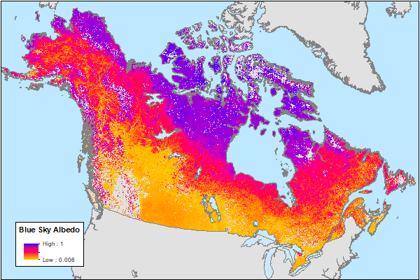
ABoVE: MODIS-Derived Daily Mean Blue Sky Albedo for Northern North America, 2000-2017 NGDA
National Aeronautics and Space Administration —
This dataset contains MODIS-derived daily mean shortwave blue sky albedo for northern North America (i.e., Canada and Alaska) and a set of quality control flags for... -
Federal
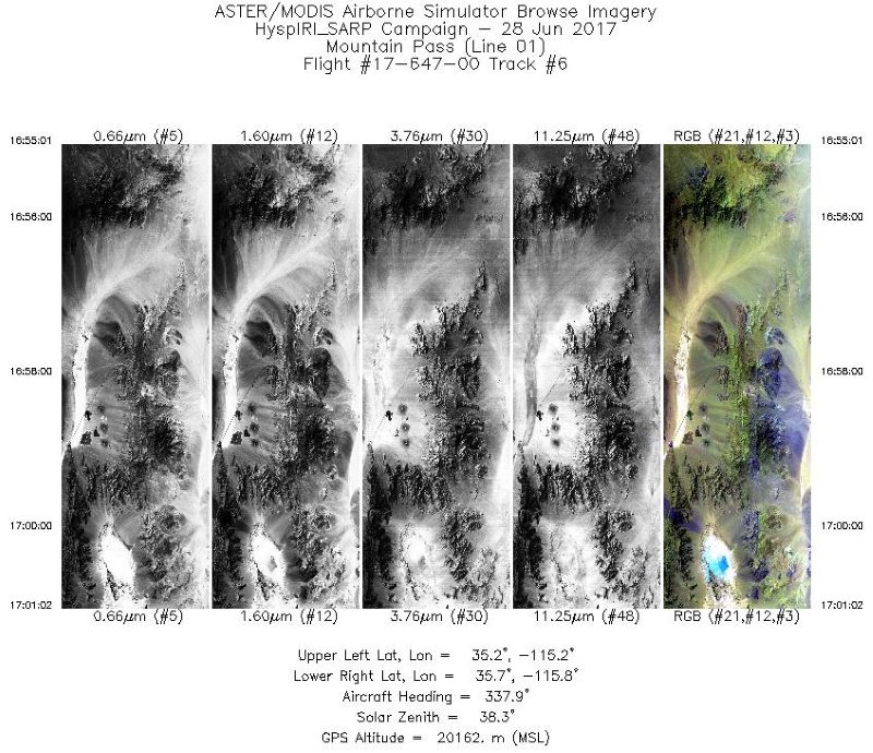
MASTER: HyspIRI Airborne Campaign, California, Summer 2017
National Aeronautics and Space Administration —
This dataset includes Level 1B (L1B) and Level 2 (L2) data products from the MODIS/ASTER Airborne Simulator (MASTER) instrument. The spectral data were collected as... -
Federal
AVIRIS-NG L2 Surface Reflectance, Facility Instrument Collection, V1
National Aeronautics and Space Administration —
This dataset contains Level 2 (L2) orthocorrected reflectance from the Airborne Visible / Infrared Imaging Spectrometer-Next Generation (AVIRIS-NG) instrument. This... -
Federal
BOREAS RSS-07 Regional LAI and FPAR Images From Ten-Day AVHRR-LAC Composites
National Aeronautics and Space Administration —
The BOREAS RSS-07 team collected various data sets to develop and validate an algorithm to allow the retrieval of the spatial distribution of LAI from remotely sensed... -
Federal
BOREAS RSS-14 Level-3 Gridded Radiometer and Satellite Surface Radiation Images
National Aeronautics and Space Administration —
The BOREAS RSS-14 team collected and processed GOES-7 and -8 images of the BOREAS region as part of their effort to characterize the incoming, reflected and emitted... -
Federal
L2 Daily Solar-Induced Fluorescence (SIF) from MetOp-B GOME-2, 2013-2021
National Aeronautics and Space Administration —
This dataset provides Level 2 (L2) Solar-Induced Fluorescence (SIF) of chlorophyll estimates derived from the Global Ozone Monitoring Experiment 2 (GOME-2) instrument... -
Federal
BOREAS Daedalus TMS Level-0 Imagery: Digital Counts in BIL Format
National Aeronautics and Space Administration —
The level-0 Daedalus TMS imagery, along with the other remotely sensed images, was collected to provide spatially extensive information about radiant energy over the... -
Federal
ABoVE: Monthly Hydrological Fluxes for Canada and Alaska, 1979-2018
National Aeronautics and Space Administration —
This dataset provides modeled estimates of monthly hydrological fluxes at 0.25-degree resolution over Alaska and Canada for the years 1979-2018. The estimates were...

Official websites use .gov
A
.gov website belongs to an official government
organization in the United States.
Secure .gov websites use HTTPS
A
lock (
) or https:// means you’ve safely connected to
the .gov website. Share sensitive information only on official,
secure websites.