
-
Federal
TES/Aura L2 Ancillary Special Observation Product V007
National Aeronautics and Space Administration —
TL2ANCS_7 is the Tropospheric Emission Spectrometer (TES)/Aura Level 2 Ancillary Special Observation Product Version 7 data product. TES was an instrument aboard... -
Federal
CERES Monthly Gridded Radiative Fluxes and Clouds Terra FM1 Edition2G
National Aeronautics and Space Administration —
CER_FSW_Terra-FM1-MODIS_Edition2G is the Clouds and the Earth's Radiant Energy System (CERES) Monthly Gridded Radiative Fluxes and Clouds Terra Flight Model (FM1)... -
Federal
MODIS/Terra+Aqua BRDF/Albedo White Sky Albedo Band1 Daily L3 Global 30ArcSec CMG V061 NGDA
National Aeronautics and Space Administration —
The MCD43D52 Version 6.1 Bidirectional Reflectance Distribution Function and Albedo (BRDF/Albedo) White-Sky Albedo dataset is produced daily using 16 days of Terra... -
Federal
VIIRS/NPP BRDF/Albedo NBAR at Solar Noon Band M8 Daily L3 Global 30ArcSec CMG V001
National Aeronautics and Space Administration —
he Suomi National Polar-Orbiting Partnership (Suomi NPP) NASA Visible Infrared Imaging Radiometer Suite (VIIRS) Bidirectional Reflectance Distribution Function (BRDF)... -
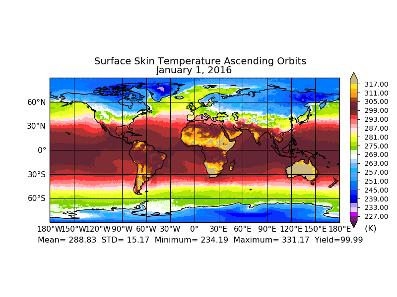
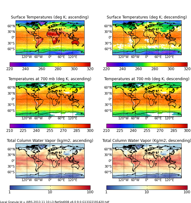
Federal
Aqua/AIRS L3 Monthly Standard Physical Retrieval (AIRS+AMSU) 1 degree x 1 degree V7.0 at GES DISC
National Aeronautics and Space Administration —
The Atmospheric Infrared Sounder (AIRS) is a grating spectrometer (R = 1200) aboard the second Earth Observing System (EOS) polar-orbiting platform, EOS Aqua. In... -
Federal
MODIS/Terra+Aqua BRDF/Albedo Parameter 1 Band 1 Daily L3 Global 30 ArcSec CMG V061 NGDA
National Aeronautics and Space Administration —
The MCD43D01 Version 6.1 Bidirectional Reflectance Distribution Function and Albedo (BRDF/Albedo) Model Parameter data set is a daily 16-day product. This product... -
Federal
VIIRS/JPSS1 Surface Reflectance 8-Day L3 Global 500m SIN Grid V002
National Aeronautics and Space Administration —
The 8-day Visible Infrared Imaging Radiometer Suite (VIIRS) (https://lpdaac.usgs.gov/dataset_discovery/viirs) Surface Reflectance (VJ109H1) Version 2 composite... -
Federal
CAR Kuwait Oil Fire Spectral Reflectance L1 V1 (CAR_KUWAITOILFIRE_L1C) at GES DISC
National Aeronautics and Space Administration —
CAR Kuwait Oil Fire mission measured bidirectional reflectance function of smoke from Kuwait oil fires during the Kuwait Oil Fire Smoke Experiment. Measurements were... -
Federal
MODIS/Aqua Surface Reflectance Daily L2G Global 250 m SIN Grid NRT NGDA
National Aeronautics and Space Administration —
The MODIS/Aqua Surface Reflectance Daily L2G Global 250m SIN Grid Near Real Time (NRT) product is an estimate of the surface spectral reflectance as it would be... -
Federal
Sounder SIPS: Suomi NPP CrIMSS Level 3 Specific Quality Control Gridded Monthly CHART Normal Spectral Resolution V1
National Aeronautics and Space Administration —
The objective of this limited edition data collection is to examine products generated by the Climate Heritage AIRS Retrieval Technique (CHART) algorithm to analyze... -
Federal
VIIRS/NPP Surface Reflectance 8-Day L3 Global 500m SIN Grid V002
National Aeronautics and Space Administration —
The 8-day Visible Infrared Imaging Radiometer Suite (VIIRS) (https://lpdaac.usgs.gov/dataset_discovery/viirs) Surface Reflectance (VNP09H1) Version 2 composite... -
Federal
ABoVE: Reflectance Spectra of Tundra Plant Communities across Northern Alaska
National Aeronautics and Space Administration —
This dataset reports full-spectrum (350-2500 nm) reflectance measurements of diverse plant communities at the plot-level and individual plant species at the leaf-... -
Federal
Arctic Vegetation Plots at Toolik Lake, Alaska, 1989
National Aeronautics and Space Administration —
This dataset provides environmental, soil, and vegetation data collected in August 1989 from 81 study plots at the Toolik Lake research site, located in the southern... -
Federal
MODIS/Aqua Surface Reflectance Daily L2G Global 500m SIN Grid NRT NGDA
National Aeronautics and Space Administration —
The MODIS/Aqua Surface Reflectance Daily L2G Global 500m SIN Grid Near Real Time (NRT) product, short name MYD09GHK, is a seven-band product computed from the MODIS... -
Federal
Net Radiation and Albedo from MODIS for Xingu River Basin, Brazil, 2000-2012 NGDA
National Aeronautics and Space Administration —
This dataset provides daily average land surface net radiation (Rnet) as an 8-day time series at approximately 0.5 km resolution for the upper Xingu River Basin in... -
Federal
FIFE CDROM Vol. 3 Contents: NS001 Thematic Mapper Simulator (TMS) Imagery, 1987-1989
National Aeronautics and Space Administration —
This data set provides aircraft-based NS001 Thematic Mapper Simulator (TMS) images of the study area associated with The First ISLSCP (International Satellite Land... -
Federal
NLDAS VIC Land Surface Model L4 Monthly Climatology 0.125 x 0.125 degree V2.0 (NLDAS_VIC0125_MC) at GES DISC
National Aeronautics and Space Administration —
This data set contains a series of land surface parameters simulated from the VIC land-surface model (LSM) for Phase 2 of the North American Land Data Assimilation... -
Federal
MODIS/Terra Land Surface Temperature/3-Band Emissivity Daily L3 Global 1km SIN Grid Day V061 NGDA
National Aeronautics and Space Administration —
A suite of Moderate Resolution Imaging Spectroradiometer (MODIS) Land Surface Temperature and Emissivity (LST&E) products are available in Collection 6.1. The... -
Federal
MODIS/Terra Land Surface Temperature/3-Band Emissivity 5-Min L2 1km V061 NGDA
National Aeronautics and Space Administration —
The MOD21 Land Surface Temperature and Emissivity (LST&E) swath data product is produced daily in five minute temporal increments of satellite acquisition. The... -
Federal
AIRS/Aqua L3 8-day Standard Physical Retrieval (AIRS-only) 1 degree X 1 degree V006 (AIRS3ST8) at GES DISC
National Aeronautics and Space Administration —
The Atmospheric Infrared Sounder (AIRS) is a grating spectrometer (R = 1200) aboard the second Earth Observing System (EOS) polar-orbiting platform, EOS Aqua. In...

Official websites use .gov
A
.gov website belongs to an official government
organization in the United States.
Secure .gov websites use HTTPS
A
lock (
) or https:// means you’ve safely connected to
the .gov website. Share sensitive information only on official,
secure websites.