
-
Federal
National Land Cover Database Commonwealth of Puerto Rico Land Cover Layer recent views
Department of the Interior —
The base Land Cover data layer for the Commonwealth of Puerto Rico was produced by the International Institute of Tropical Forestry(IITF) and crosswalked to NLCD... -
Federal
NHAP = National High-Altitude Aerial Photography: 1980 - 1989 recent views
Department of the Interior —
'The National High Altitude Photography (NHAP) program, which was operated from 1980-1989, was coordinated by the U.S. Geological Survey as an interagency project to... -
Federal
NAPP = National Aerial Photography Program 1:40,000 Scale: 1987 - 2007 recent views
Department of the Interior —
'The National Aerial Photography Program (NAPP) was coordinated by the USGS as an interagency project to acquire cloud-free aerial photographs at an altitude of... -
Federal
Declass 1 (1996) = Corona, Lanyard, & Argon Missions - KH1 thru KH6: 1960 - 1972. recent views
Department of the Interior —
'On February 24, 1995, President Clinton signed an Executive Order, directing the declassification of intelligence imagery acquired by the first generation of United... -
Federal
Photographs and locations of bottom still imagery collected in Little Egg Inlet and offshore the southern end of Long Beach Island, NJ, during USGS Field Activity 2018-049-FA (JPEG images, point shapefile, and CSV file) recent views
Department of the Interior —
The natural resiliency of the New Jersey barrier island system, and the efficacy of management efforts to reduce vulnerability, depends on the ability of the system... -
Federal
Earth Resources Observation and Science (EROS) Center's Image of the Week Gallery recent views
National Aeronautics and Space Administration —
The Earth Resources Observation and Science (EROS) Center manages the this image of the week gallery. -
Federal
Declass 2 (2002) = KH-7 and KH-9 Global Camera Photos: 1963 - 1980 recent views
Department of the Interior —
'Keyhole (KH) satellite systems KH-7 and KH-9 acquired photographs of the Earth\'s surface with a telescopic camera system and transported the exposed film through... -
Federal
Earth Observing-1 Hyperion: 2001-Present recent views
Department of the Interior —
'The Earth Observing-1(EO-1) satellite was launched on November 21, 2000 by the U.S. Geological Survey (USGS) and the National Aeronautics and Space Administration... -
University
Albuquerque, NM 1:250,000 Quad East Half USGS Land Use/Land Cover, 2000 recent views
Earth Data Analysis Center, University of New Mexico —
This land cover data set was produced as part of a cooperative project between the U.S. Geological Survey (USGS) and the U.S. Environmental Protection Agency (USEPA)... -
University
Silver City, NM 1:250,000 Quad East Half USGS Land Use/Land Cover, 2000 recent views
Earth Data Analysis Center, University of New Mexico —
This land cover data set was produced as part of a cooperative project between the U.S. Geological Survey (USGS) and the U.S. Environmental Protection Agency (USEPA)... -
University
Aztec, NM 1:250,000 Quad East Half USGS Land Use/Land Cover, 2000 recent views
Earth Data Analysis Center, University of New Mexico —
This land cover data set was produced as part of a cooperative project between the U.S. Geological Survey (USGS) and the U.S. Environmental Protection Agency (USEPA)... -
University
Aztec, NM 1:250,000 Quad West Half USGS Land Use/Land Cover, 2000 recent views
Earth Data Analysis Center, University of New Mexico —
This land cover data set was produced as part of a cooperative project between the U.S. Geological Survey (USGS) and the U.S. Environmental Protection Agency (USEPA)... -
University
Las Cruces, NM 1:250,000 Quad West Half USGS Land Use/Land Cover, 2000 recent views
Earth Data Analysis Center, University of New Mexico —
This land cover data set was produced as part of a cooperative project between the U.S. Geological Survey (USGS) and the U.S. Environmental Protection Agency (USEPA)... -
University
Saint Johns, AZ 1:250,000 Quad East Half USGS Land Use/Land Cover, 2000 recent views
Earth Data Analysis Center, University of New Mexico —
This land cover data set was produced as part of a cooperative project between the U.S. Geological Survey (USGS) and the U.S. Environmental Protection Agency (USEPA)... -
University
Roswell, NM 1:250,000 Quad East Half USGS Land Use/Land Cover, 2000 recent views
Earth Data Analysis Center, University of New Mexico —
This land cover data set was produced as part of a cooperative project between the U.S. Geological Survey (USGS) and the U.S. Environmental Protection Agency (USEPA)... -
University
Carlsbad, NM 1:250,000 Quad West Half USGS Land Use/Land Cover, 2000 recent views
Earth Data Analysis Center, University of New Mexico —
This land cover data set was produced as part of a cooperative project between the U.S. Geological Survey (USGS) and the U.S. Environmental Protection Agency (USEPA)... -
University
Raton, NM 1:250,000 Quad East Half USGS Land Use/Land Cover, 2000 recent views
Earth Data Analysis Center, University of New Mexico —
This land cover data set was produced as part of a cooperative project between the U.S. Geological Survey (USGS) and the U.S. Environmental Protection Agency (USEPA)... -
University
Las Cruces, NM 1:250,000 Quad East Half USGS Land Use/Land Cover, 2000 recent views
Earth Data Analysis Center, University of New Mexico —
This land cover data set was produced as part of a cooperative project between the U.S. Geological Survey (USGS) and the U.S. Environmental Protection Agency (USEPA)... -
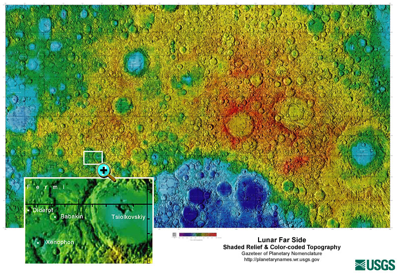
Federal
Gazetteer of Planetary Nomenclature: Moon: 1:10 million-scale Shaded Relief and Color-coded Topography: Far Side recent views
National Aeronautics and Space Administration —
These lunar maps display the four different areas of the moon with color-coded topography in low and high resolution approved by the International Astronomical Union... -
University
Santa Fe, NM 1:250,000 Quad East Half USGS Land Use/Land Cover, 2000 recent views
Earth Data Analysis Center, University of New Mexico —
This land cover data set was produced as part of a cooperative project between the U.S. Geological Survey (USGS) and the U.S. Environmental Protection Agency (USEPA)...

Official websites use .gov
A
.gov website belongs to an official government
organization in the United States.
Secure .gov websites use HTTPS
A
lock (
) or https:// means you’ve safely connected to
the .gov website. Share sensitive information only on official,
secure websites.