
-
Federal
Maritime Limits and Boundaries of United States of America NGDA recent views
National Oceanic and Atmospheric Administration, Department of Commerce —
NOAA is responsible for depicting on its nautical charts the limits of the 12 nautical mile Territorial Sea, 24 nautical mile Contiguous Zone, and 200 nautical mile... -
Federal
Spring Bottom Trawl Survey recent views
National Oceanic and Atmospheric Administration, Department of Commerce —
The standardized NEFSC Spring Bottom Trawl Survey was initiated in 1968 and covered an area from Cape Hatteras, NC, to Nova Scotia, Canada, at depths >27m.... -
Federal
Marine Animal Incident Database recent views
National Oceanic and Atmospheric Administration, Department of Commerce —
Large whale stranding, death, ship strike and entanglement incidents are all recorded to monitor the health of each population and track anthropogenic factors that... -
Federal
Fishing Revenue-Intensity Raster Database, 2007-2012 recent views
National Oceanic and Atmospheric Administration, Department of Commerce —
These revenue-intensity rasters were built as part of an effort to improve upon the spatial precision of self-reported Vessel Trip Report (VTR) fishing locations.... -
Federal
Regional Hydrodynamic Model Outputs of the NOAA Gulf of Maine Operational Forecast System (GoMOFS) recent views
National Oceanic and Atmospheric Administration, Department of Commerce —
NOAA's National Ocean Service (NOS) has developed a Gulf of Maine Operational Forecast System (GoMOFS). Based on Rutgers University's Regional Ocean Modeling System... -
Federal
OBPRELIM Observer Preliminary Data System recent views
National Oceanic and Atmospheric Administration, Department of Commerce —
Paper logs are the primary data collection tool used by observers of the Northeast Fisheries Observer Program and Industry Funded Scallop Program deployed on... -
Federal
W00587: NOS Hydrographic Survey , 2019-08-29 recent views
National Oceanic and Atmospheric Administration, Department of Commerce —
The National Oceanic and Atmospheric Administration (NOAA) has the statutory mandate to collect hydrographic data in support of nautical chart compilation for safe... -
Federal
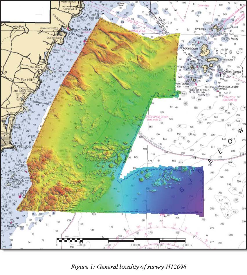
H12696: NOS Hydrographic Survey , Approaches to Portsmouth, NH, 2014-05-14 recent views
National Oceanic and Atmospheric Administration, Department of Commerce —
The National Oceanic and Atmospheric Administration (NOAA) has the statutory mandate to collect hydrographic data in support of nautical chart compilation for safe... -
Federal
IVR EFP Database recent views
National Oceanic and Atmospheric Administration, Department of Commerce —
This database contains trip-level reports submitted by vessels participating in Exempted Fishery projects with IVR reporting requirements. -
Federal
Historical Survey Data Archive recent views
National Oceanic and Atmospheric Administration, Department of Commerce —
To preserve NEFSC historical data, images of biological and oceanographic data sheets (1948-1975) were scanned to digital format and can be queried through a portal... -
Federal
H06567: NOS Hydrographic Survey , 1940-12-31 recent views
National Oceanic and Atmospheric Administration, Department of Commerce —
The National Oceanic and Atmospheric Administration (NOAA) has the statutory mandate to collect hydrographic data in support of nautical chart compilation for safe... -
Federal
Bar Harbor, Maine 1/3 Arc-second NAVD 88 Coastal Digital Elevation Model recent views
National Oceanic and Atmospheric Administration, Department of Commerce —
NOAA's National Geophysical Data Center (NGDC) is building high-resolution digital elevation models (DEMs) for select U.S. coastal regions. These integrated... -
Federal
Benthic Habitat Database recent views
National Oceanic and Atmospheric Administration, Department of Commerce —
The NOAA Northeast Fisheries Science Center has, through the years, accumulated an extensive data base of qualitative and quantitative (wet weight and number per... -
Federal
Stock Assessment Supplementary Information (SASINF) recent views
National Oceanic and Atmospheric Administration, Department of Commerce —
In the interest of efficiency, clarity and standardization of stock assessment materials, the stock assessment reports for the 2015 Groundfish update have been... -
Federal
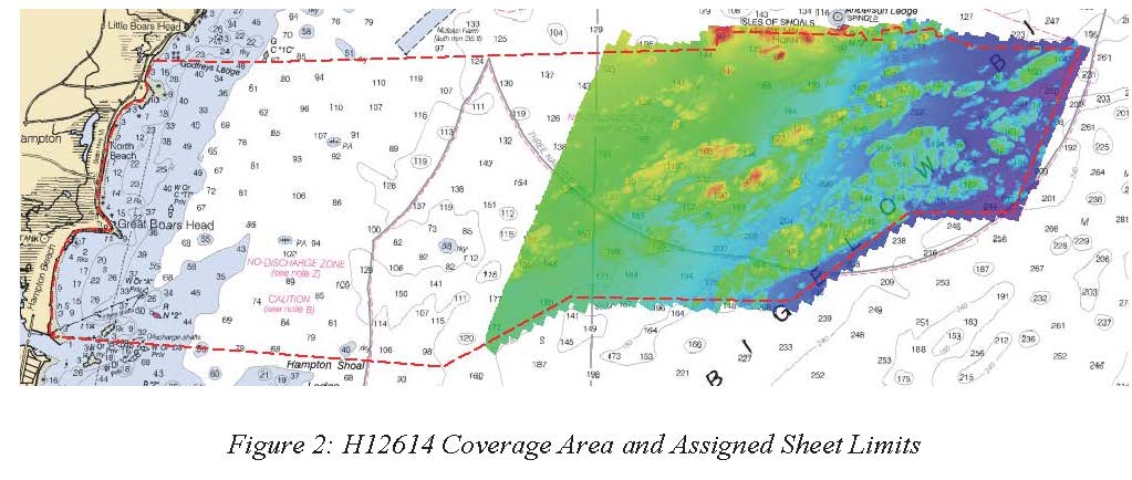
H12614: NOS Hydrographic Survey , Approaches to Portsmouth, NH, 2013-09-13 recent views
National Oceanic and Atmospheric Administration, Department of Commerce —
The National Oceanic and Atmospheric Administration (NOAA) has the statutory mandate to collect hydrographic data in support of nautical chart compilation for safe... -
Federal
Fall Bottom Trawl Survey recent views
National Oceanic and Atmospheric Administration, Department of Commerce —
The standardized NEFSC Fall Bottom Trawl Survey was initiated in 1963 and covered an area from Hudson Canyon, NY to Nova Scotia, Canada. Throughout the years,... -
Federal
Water Density Raster Images for the Gulf of Maine recent views
National Oceanic and Atmospheric Administration, Department of Commerce —
This geodatabase contains water density raster images for the Gulf of Maine that were interpolated from water density (sigma t or kilograms/ meters cubed) point data...

Official websites use .gov
A
.gov website belongs to an official government
organization in the United States.
Secure .gov websites use HTTPS
A
lock (
) or https:// means you’ve safely connected to
the .gov website. Share sensitive information only on official,
secure websites.