
-
Federal
W00587: NOS Hydrographic Survey , 2019-08-29 recent views
National Oceanic and Atmospheric Administration, Department of Commerce —
The National Oceanic and Atmospheric Administration (NOAA) has the statutory mandate to collect hydrographic data in support of nautical chart compilation for safe... -
Federal
National Fish Habitat Action Plan (NFHAP) - Coastal Spatial Framework and Coastal Indicator Data recent views
National Oceanic and Atmospheric Administration, Department of Commerce —
The NFHAP Coastal Spatial Framework and Indicator Datasets consist of a geospatial base layer developed in ArcGIS, and associated data fields joined to the spatial... -
Federal
W00590: NOS Hydrographic Survey , 2020-08-20 recent views
National Oceanic and Atmospheric Administration, Department of Commerce —
The National Oceanic and Atmospheric Administration (NOAA) has the statutory mandate to collect hydrographic data in support of nautical chart compilation for safe... -
Federal
W00533: NOS Hydrographic Survey , 2012-12-31 recent views
National Oceanic and Atmospheric Administration, Department of Commerce —
The National Oceanic and Atmospheric Administration (NOAA) has the statutory mandate to collect hydrographic data in support of nautical chart compilation for safe... -
Federal
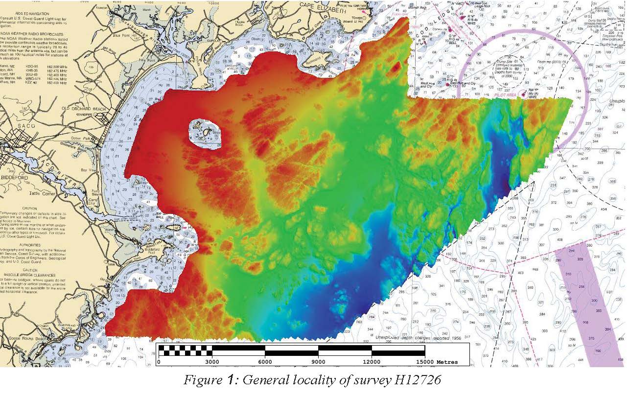
H12726: NOS Hydrographic Survey , 2015-02-05 recent views
National Oceanic and Atmospheric Administration, Department of Commerce —
The National Oceanic and Atmospheric Administration (NOAA) has the statutory mandate to collect hydrographic data in support of nautical chart compilation for safe... -
Federal
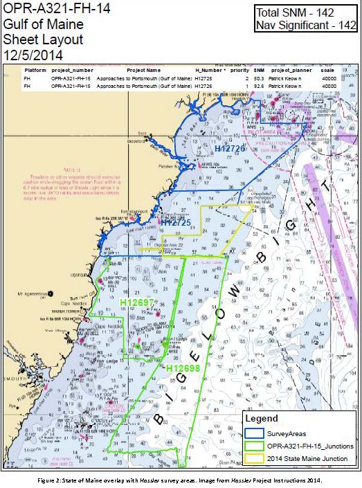
H12698: NOS Hydrographic Survey , Approaches to Portsmouth, NH, 2014-05-30 recent views
National Oceanic and Atmospheric Administration, Department of Commerce —
The National Oceanic and Atmospheric Administration (NOAA) has the statutory mandate to collect hydrographic data in support of nautical chart compilation for safe... -
Federal
W00549: NOS Hydrographic Survey , External Source Data 2020, 2019-05-27 recent views
National Oceanic and Atmospheric Administration, Department of Commerce —
The National Oceanic and Atmospheric Administration (NOAA) has the statutory mandate to collect hydrographic data in support of nautical chart compilation for safe... -
Federal
W00181: NOS Hydrographic Survey , Outside Source Data Surveys - 2007, 2004-03-13 recent views
National Oceanic and Atmospheric Administration, Department of Commerce —
The National Oceanic and Atmospheric Administration (NOAA) has the statutory mandate to collect hydrographic data in support of nautical chart compilation for safe... -
Federal
W00288: NOS Hydrographic Survey , 2014-10-06 recent views
National Oceanic and Atmospheric Administration, Department of Commerce —
The National Oceanic and Atmospheric Administration (NOAA) has the statutory mandate to collect hydrographic data in support of nautical chart compilation for safe... -
Federal
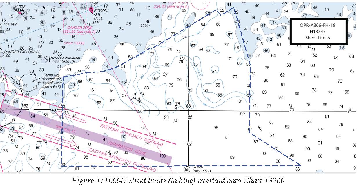
H13347: NOS Hydrographic Survey , 2020-09-29 recent views
National Oceanic and Atmospheric Administration, Department of Commerce —
The National Oceanic and Atmospheric Administration (NOAA) has the statutory mandate to collect hydrographic data in support of nautical chart compilation for safe... -
Federal
W00535: NOS Hydrographic Survey , External Source Data 2020, 2017-04-30 recent views
National Oceanic and Atmospheric Administration, Department of Commerce —
The National Oceanic and Atmospheric Administration (NOAA) has the statutory mandate to collect hydrographic data in support of nautical chart compilation for safe... -
Federal
W00534: NOS Hydrographic Survey , External Source Data 2020, 2012-08-31 recent views
National Oceanic and Atmospheric Administration, Department of Commerce —
The National Oceanic and Atmospheric Administration (NOAA) has the statutory mandate to collect hydrographic data in support of nautical chart compilation for safe... -
Federal
W00538: NOS Hydrographic Survey , External Source Data 2020, 2013-12-31 recent views
National Oceanic and Atmospheric Administration, Department of Commerce —
The National Oceanic and Atmospheric Administration (NOAA) has the statutory mandate to collect hydrographic data in support of nautical chart compilation for safe... -
Federal
W00536: NOS Hydrographic Survey , External Source Data 2020, 2017-04-30 recent views
National Oceanic and Atmospheric Administration, Department of Commerce —
The National Oceanic and Atmospheric Administration (NOAA) has the statutory mandate to collect hydrographic data in support of nautical chart compilation for safe... -
Federal
W00593: NOS Hydrographic Survey , External Source Data 2021, 2020-09-10 recent views
National Oceanic and Atmospheric Administration, Department of Commerce —
The National Oceanic and Atmospheric Administration (NOAA) has the statutory mandate to collect hydrographic data in support of nautical chart compilation for safe... -
Federal
H12613: NOS Hydrographic Survey , Approaches to Portsmouth, NH, 2013-09-08 recent views
National Oceanic and Atmospheric Administration, Department of Commerce —
The National Oceanic and Atmospheric Administration (NOAA) has the statutory mandate to collect hydrographic data in support of nautical chart compilation for safe... -
Federal
H12615: NOS Hydrographic Survey , Approaches to Portsmouth, NH, 2013-09-09 recent views
National Oceanic and Atmospheric Administration, Department of Commerce —
The National Oceanic and Atmospheric Administration (NOAA) has the statutory mandate to collect hydrographic data in support of nautical chart compilation for safe... -
Federal
NOS Hydrodynamic Model Outputs of Operational Forecast System (OFS) recent views
National Oceanic and Atmospheric Administration, Department of Commerce —
NOAA develops, operates and maintains a national network of operational nowcast and forecast hydrodynamic modeling systems referred to as Operational Forecast Systems... -
Federal
Maine and New Hampshire 2016 NATURAL_HAZARD Polygons recent views
National Oceanic and Atmospheric Administration, Department of Commerce —
This feature class resides within the SOCECON Feature Data Set of the Maine and New Hampshire 2016 ESI geodatabase. It contains vector polygons representing Natural... -
Federal
Shoreline Mapping Program of GULF OF MAINE, CAPE SMALL TO PEMAQUID POINT, ME, ME1102C-CM-N NGDA recent views
National Oceanic and Atmospheric Administration, Department of Commerce —
These data provide an accurate high-resolution shoreline compiled from imagery of GULF OF MAINE, CAPE SMALL TO PEMAQUID POINT, ME . This vector shoreline data is...

Official websites use .gov
A
.gov website belongs to an official government
organization in the United States.
Secure .gov websites use HTTPS
A
lock (
) or https:// means you’ve safely connected to
the .gov website. Share sensitive information only on official,
secure websites.
.jpg)