
-
Federal
Global Hydrologic Soil Groups (HYSOGs250m) for Curve Number-Based Runoff Modeling
National Aeronautics and Space Administration —
This dataset - HYSOGs250m - represents a globally consistent, gridded dataset of hydrologic soil groups (HSGs) with a geographical resolution of 1/480 decimal... -
Federal
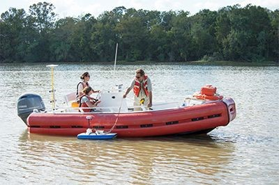
Delta-X: AirSWOT L2 Geocoded Water Surface Elevation, MRD, Louisiana, 2021, Version 2
National Aeronautics and Space Administration —
This dataset contains Level 2 (L2) AirSWOT geocoded products, including estimated water surface elevation. The AirSWOT instrument is a Ka-band interferometer and for... -
Federal
Pre-Delta-X: AVIRIS-derived Total Suspended Solids Maps for MRD, LA, USA, 2015-2016
National Aeronautics and Space Administration —
This dataset includes total suspended solids (TSS) at the water surface across the Atchafalaya and Terrebonne Basins in Southern Louisiana, USA, within the... -
Federal
FIFE CDROM Vol. 3 Contents: NS001 Thematic Mapper Simulator (TMS) Imagery, 1987-1989
National Aeronautics and Space Administration —
This data set provides aircraft-based NS001 Thematic Mapper Simulator (TMS) images of the study area associated with The First ISLSCP (International Satellite Land... -
Federal
BOREAS/SRC AMS Suite A Surface Meteorological and Radiation Data: 1996
National Aeronautics and Space Administration —
Contains the data collected in 1996 by the AMS suite A instrument set operated by SRC and provided to BORIS. -
Federal
Tidal Wetlands Soil Organic Carbon and Estuarine Characteristics, USA, 1972-2015
National Aeronautics and Space Administration —
This dataset provides a synthesis of soil organic carbon (SOC) estimates and a variety of other environmental information from tidal wetlands within estuaries in the... -
Federal
ABoVE: Lake Growing Season Green Surface Reflectance Trends, AK and Canada, 1984-2019
National Aeronautics and Space Administration —
This dataset provides an annual time series of Landsat green surface reflectance and the derived annual trend during the growing season (June and July) for 472,890... -
Federal
Arctic Vegetation Plots, Prudhoe Bay ArcSEES Road Study, Lake Colleen, Alaska, 2014
National Aeronautics and Space Administration —
This dataset provides environmental, soil, and vegetation data collected from study plots in the vicinity of Lake Colleen off the Spine Road at Prudhoe Bay, Alaska,... -
Federal
Delta-X: UAVSAR L1 Single Look Complex (SLC) Stack Products, MRD, Louisiana, 2021
National Aeronautics and Space Administration —
This dataset contains UAVSAR Level 1 (L1) Single Look Complex (SLC) stack products for Delta-X flight lines acquired during 2021-03-27 to 2021-04-18 (spring) and... -
Federal
ABoVE: Surface Water Extent, Boreal and Tundra Regions, North America, 1991-2011
National Aeronautics and Space Administration —
This data set provides the location and extent of surface water (open water not including vegetated wetlands) for the entire Boreal and Tundra regions of North... -
Federal
Delta-X: UAVSAR L2 Interferometric Products, MRD, Louisiana, 2021
National Aeronautics and Space Administration —
This dataset contains georeferenced UAVSAR Level 2 (L2) interferometric products for Delta-X flight lines acquired during the spring (2021-03-27 to 2021-04-18) and... -
Federal
Arctic Vegetation Plots in Northern NWT and YT, Canada, 1965-1966
National Aeronautics and Space Administration —
This dataset provides vegetation, soil, and plot characteristics for 154 study plots located at three sites across the Richardson Mountains, Northwest Territories... -
Federal
Pre-Delta-X: River Discharge Channel Surveys across Atchafalaya Basin, LA, USA, 2016
National Aeronautics and Space Administration —
This dataset provides river discharge measurements collected at selected locations across the Atchafalaya River Basin, within the Mississippi River Delta (MRD)... -
Federal
Pre-Delta-X: Spectral Reflectance of Water Surface, Atchafalaya Basin, LA, USA, 2016
National Aeronautics and Space Administration —
This dataset provides measurements of in situ remote-sensing reflectance (Rrs; per steradian) of surface water across Atchafalaya Basin, southern coastal Louisiana,... -
Federal
ISLSCP II Atmospheric Carbon Dioxide Consumption by Continental Erosion
National Aeronautics and Space Administration —
The Continental Atmospheric CO2 Consumption data set represents gridded estimates for the riverine export of carbon and of sediments based on empirical models. All... -
Federal
ABoVE: Monthly Hydrological Fluxes for Canada and Alaska, 1979-2018
National Aeronautics and Space Administration —
This dataset provides modeled estimates of monthly hydrological fluxes at 0.25-degree resolution over Alaska and Canada for the years 1979-2018. The estimates were... -
Federal
LBA-ECO LC-07 Monthly Inundated Areas, Amazon, Orinoco and Pantanal Basins: 1978-1987
National Aeronautics and Space Administration —
This data set reports the monthly record of inundated area, in square km, for six floodplain and open water regions in South America. The following floodplains were... -
Federal
LBA-ECO ND-01 Watershed Deforestation from Landsat TM Series, Rondonia, Brazil: 1999
National Aeronautics and Space Administration —
This data set provides estimates of watershed deforestation, as a proportion of the total area of watersheds, in Rondonia, Brazil for 1999. Deforestation maps were... -
Federal
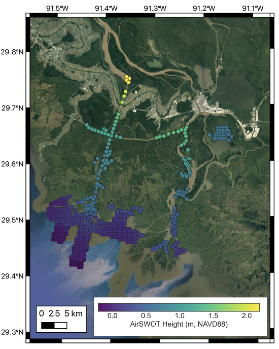
Delta-X: AirSWOT L3 Water Surface Elevations, MRD, Louisiana, 2021
National Aeronautics and Space Administration —
This dataset contains water surface elevations at selected point locations generated from the AirSWOT data collected during the Spring and Fall 2021 Delta-X... -
Federal
LBA-ECO TG-09 Soil Isotopic C, N, H2O, and N2O Data, Tapajos National Forest, Brazil
National Aeronautics and Space Administration —
This data set reports the results of carbon, nitrogen, and oxygen isotopic analyses of soil, soil water, and N2O soil gas samples; total soil carbon and nitrogen...

Official websites use .gov
A
.gov website belongs to an official government
organization in the United States.
Secure .gov websites use HTTPS
A
lock (
) or https:// means you’ve safely connected to
the .gov website. Share sensitive information only on official,
secure websites.