
-
Federal
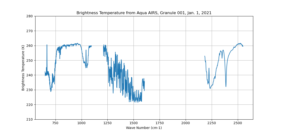
AIRS/Aqua L1B Infrared (IR) geolocated and calibrated radiances V005 (AIRIBRAD) at GES DISC at GES DISC
National Aeronautics and Space Administration —
WARNING: On 2021/09/23 the EOS Aqua executed a Deep Space Maneuver (DSM). In the DSM, the spacecraft is turned such that the normal Earth field of regard is deep... -
Federal
Sounder SIPS: Sun Synchronous 13:30 orbit Climate Hyperspectral InfraRed Product (CHIRP): Calibrated Radiances from EOS-Aqua, V2 (SNDR13CHRP1AQCal) at GES DISC
National Aeronautics and Space Administration —
The Climate Hyperspectral Infrared Radiance Product (CHIRP) is a Level 1 radiance product derived from Atmospheric Infrared Sounder (AIRS) on EOS-AQUA and the Cross-... -
Federal
AIRS/Aqua L1B Near Real Time (NRT) Infrared (IR) geolocated and calibrated radiances V005 (AIRIBRAD_NRT) at GES DISC
National Aeronautics and Space Administration —
WARNING: On 2021/09/23 the EOS Aqua executed a Deep Space Maneuver (DSM). In the DSM, the spacecraft is turned such that the normal Earth field of regard is deep... -
Federal
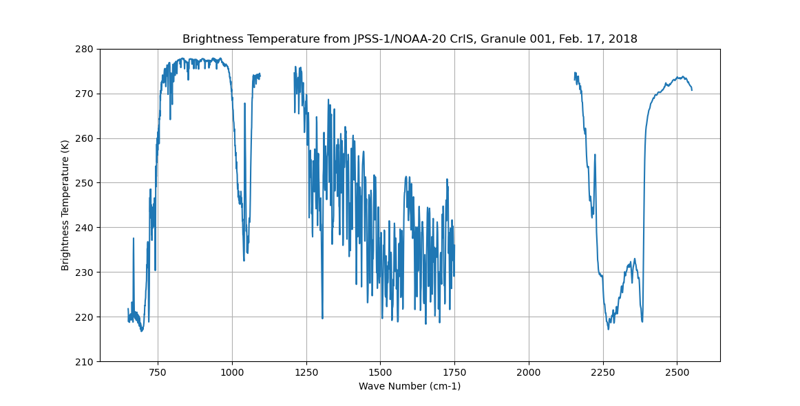
Sounder SIPS: Sun Synchronous 13:30 orbit Climate Hyperspectral InfraRed Product (CHIRP): Calibrated Radiances from JPSS-1/NOAA-20, V2 (SNDR13CHRP1J1Cal) at GES DISC
National Aeronautics and Space Administration —
The Climate Hyperspectral Infrared Radiance Product (CHIRP) is a Level 1 radiance product derived from Atmospheric Infrared Sounder (AIRS) on EOS-AQUA and the Cross-... -
Federal
First ISCCP Regional Experiment (FIRE) Arctic Cloud Experiment (ACE) University of Washington CV580 Aircraft
National Aeronautics and Space Administration —
This data set consists of measurements provided by the University of Washington instruments flown onboard their CV580 aircraft during the FIR ACE/SHEBA field... -
Federal
CALIPSO Wide Field Camera Level 1B 125m Native Science data, Validated Stage 1 V3-02
National Aeronautics and Space Administration —
CAL_WFC_L1_125m-ValStage1-V3-02 data are Cloud-Aerosol Lidar and Infrared Pathfinder Satellite Observation (CALIPSO) Wide Field Camera (WFC) Level 1B 125 m Native... -
Federal
CERES Single Scanner Footprint (SSF) TOA/Surface Fluxes, Clouds and Aerosols NPP-FM5 Edition2A
National Aeronautics and Space Administration —
CER_SSF_NPP-FM5_Edition2A data are CERES observed TOA fluxes, MODIS clouds and aerosols, and parameterized surface fluxes.The Single Scanner Footprint TOA/Surface... -
Federal
CALIPSO Wide Field Camera Level 1B 125m Native Science data, Validated Stage 1 V3-01
National Aeronautics and Space Administration —
CAL_WFC_L1_125m-ValStage1-V3-01 data are Cloud-Aerosol Lidar and Infrared Pathfinder Satellite Observation (CALIPSO) Wide Field Camera (WFC) Level 1B 125m Native... -
Federal
CERES Clouds and Radiative Swath Terra FM1 MODIS Edition2G
National Aeronautics and Space Administration —
CER_CRS_Terra-FM1-MODIS_Edition2G is the Clouds and the Earth's Radiant Energy System (CERES) Clouds and Radiative Swath (CRS) Terra Flight Model 1 (FM1) Moderate-... -
Federal
Sounder SIPS: Sun Synchronous 13:30 orbit Climate Hyperspectral InfraRed Product (CHIRP): Calibrated Radiances from EOS-Aqua, S-NPP, JPSS-1/NOAA-20, V2 (SNDR13CHRP1) at GES DISC
National Aeronautics and Space Administration —
The Climate Hyperspectral Infrared Radiance Product (CHIRP) is a Level 1 radiance product derived from Atmospheric Infrared Sounder (AIRS) on EOS-AQUA and the Cross-... -
Federal
CALIPSO Wide Field Camera Level 1B 1 km Registered Science data, Validated Stage 1 V3-02
National Aeronautics and Space Administration —
CAL_WFC_L1_IIR-ValStage1-V3-02 data are Cloud-Aerosol Lidar and Infrared Pathfinder Satellite Observation (CALIPSO) Wide Field Camera (WFC) Level 1B 1 km Registered... -
Federal
CERES MODIS Cloud Retrievals in ISCCP-D2like Format Nighttime Aqua FM4 Edition3A NGDA
National Aeronautics and Space Administration —
CER_ISCCP-D2like-Nit_Aqua-FM4-MODIS_Edition3A is the Clouds and the Earth's Radiant Energy System (CERES) Moderate Resolution Imaging Spectroradiometer (MODIS) Cloud... -
Federal
AIRS/Aqua L1C Near Real Time (NRT) Infrared (IR) resampled and corrected radiances V6.7 (AIRICRAD_NRT) at GES DISC
National Aeronautics and Space Administration —
The Atmospheric Infrared Sounder (AIRS) is a grating spectrometer (R = 1200) aboard the second Earth Observing System (EOS) polar-orbiting platform, EOS Aqua. In... -
Federal
CALIPSO Wide Field Camera Level 1B 1 km Registered Science data, Validated Stage 1 V3-01
National Aeronautics and Space Administration —
CAL_WFC_L1_IIR-ValStage1-V3-01 data are Cloud-Aerosol Lidar and Infrared Pathfinder Satellite Observation (CALIPSO) Wide Field Camera (WFC) Level 1B 1 km Registered... -
Federal
SAFARI 2000 C-130 Aerosol and Meteorological Data, Dry Season 2000
National Aeronautics and Space Administration —
The Met Office C-130 research aircraft was based at Windhoek, Namibia, between September 5-16, 2000, where it conducted a series of flights over Namibia as part of... -
Federal
CERES Single Scanner Footprint (SSF) TOA/Surface Fluxes, Clouds and Aerosols NOAA20-FM6-VIIRS Edition1B
National Aeronautics and Space Administration —
CER_SSF_NOAA20-FM6_Edition1B data are Clouds and the Earth's Radiant Energy System (CERES) observed Top of Atmosphere (TOA) fluxes, Moderate Resolution Imaging... -
Federal
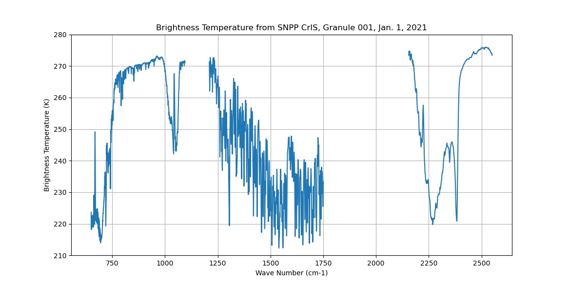
Sounder SIPS: Sun Synchronous 13:30 orbit Climate Hyperspectral InfraRed Product (CHIRP): Calibrated Radiances from S-NPP, V2 (SNDR13CHRP1SNCal) at GES DISC
National Aeronautics and Space Administration —
The Climate Hyperspectral Infrared Radiance Product (CHIRP) is a Level 1 radiance product derived from Atmospheric Infrared Sounder (AIRS) on EOS-AQUA and the Cross-... -
Federal
CERES Monthly Gridded Radiative Fluxes and Clouds Terra FM1 Edition2F
National Aeronautics and Space Administration —
CER_FSW_Terra-FM1-MODIS_Edition2F is the Clouds and the Earth's Radiant Energy System (CERES) Monthly Gridded Radiative Fluxes and Clouds Terra Flight Model 1 (FM1)... -
Federal
CALIPSO Wide Field Camera Level 1B 1 km Native Science data, Validated Stage 1 V3-02
National Aeronautics and Space Administration —
CAL_WFC_L1_1Km-ValStage1-V3-02 data are Cloud-Aerosol Lidar and Infrared Pathfinder Satellite Observation (CALIPSO) Wide Field Camera (WFC), Level 1B 1 km Native... -
Federal
Sulfates, Clouds and Radiation America NASA ER-2 Moderate Resolution Imaging Spectrometer (MODIS) Airborne Simulator (MAS) Data
National Aeronautics and Space Administration —
SCAR_A_ER2_MAS data are Sulfates, Clouds and Radiation America (SCARA) NASA ER2 Moderate Resolution Imaging Spectrometer (MODIS) Airborne Simulator (MAS) Data in...

Official websites use .gov
A
.gov website belongs to an official government
organization in the United States.
Secure .gov websites use HTTPS
A
lock (
) or https:// means you’ve safely connected to
the .gov website. Share sensitive information only on official,
secure websites.