
-
Federal
NOAA ESRI Grid - depth predictions bathymetry model in New York offshore planning area from Biogeography Branch
National Oceanic and Atmospheric Administration, Department of Commerce —
This dataset represents depth predictions from a bathymetric model developed for the New York offshore spatial planning area. The model also includes spatially-... -
Federal
2002 Long Island South Shore Estuary Benthic Habitat Line Data Set
National Oceanic and Atmospheric Administration, Department of Commerce —
In June 2002, 200 1:20,000 scale conventional-color metric film diapositives for Long Island, New York were collected as part of an effort to map submerged aquatic... -
Federal
Atlantic Surfclam and Ocean Quahog Survey
National Oceanic and Atmospheric Administration, Department of Commerce —
The standardized NEFSC Atlantic Surfclam and Ocean Quahog Survey has covered an area from Cape Hatteras to Georges Bank. The survey was conducted every two or three... -
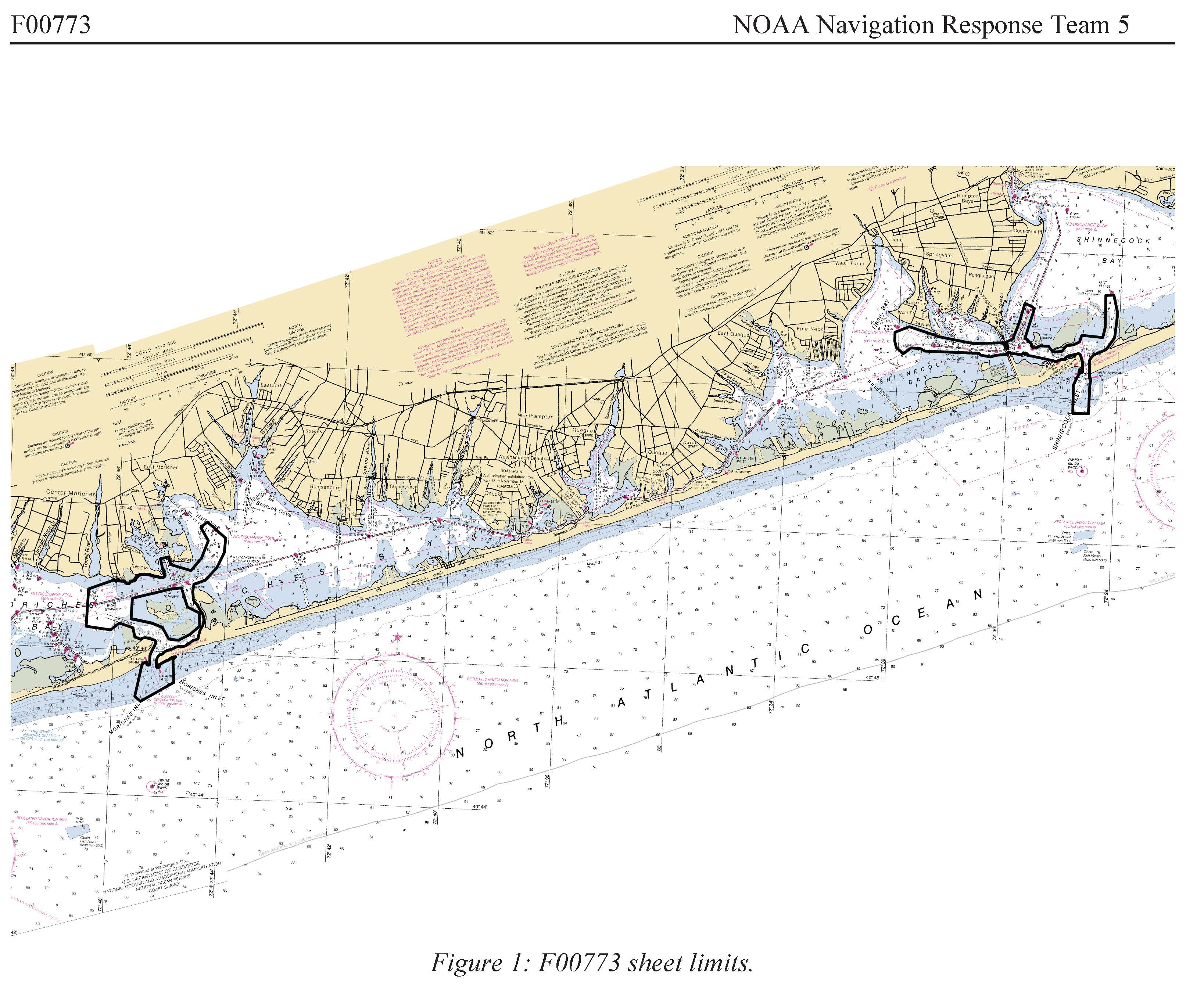
Federal
F00773: NOS Hydrographic Survey , 2019-06-07
National Oceanic and Atmospheric Administration, Department of Commerce —
The National Oceanic and Atmospheric Administration (NOAA) has the statutory mandate to collect hydrographic data in support of nautical chart compilation for safe... -
Federal
NOAA ESRI Grid - depth uncertainty predictions in New York offshore planning area from Biogeography Branch bathymetry model
National Oceanic and Atmospheric Administration, Department of Commerce —
This dataset represents depth uncertainty predictions from a bathymetric model developed for the New York offshore spatial planning area. The model also includes... -
Federal
NOAA ESRI Shapefile - sediment composition class predictions in New York offshore planning area from Biogeography Branch
National Oceanic and Atmospheric Administration, Department of Commerce —
This dataset represents sediment composition class predictions from a sediment spatial model developed for the New York offshore spatial planning area. The predictive... -
Federal
NOAA ESRI Grid - sediment size predictions model in New York offshore planning area from Biogeography Branch
National Oceanic and Atmospheric Administration, Department of Commerce —
This dataset represents sediment size predictions from a sediment spatial model developed for the New York offshore spatial planning area. The model also includes... -
Federal
H12997: NOS Hydrographic Survey , 2017-05-13
National Oceanic and Atmospheric Administration, Department of Commerce —
The National Oceanic and Atmospheric Administration (NOAA) has the statutory mandate to collect hydrographic data in support of nautical chart compilation for safe... -
Federal
NOAA ESRI Grid - predictions of relative uncertainty for seabird diversity metrics in the New York offshore planning area by NOAA Biogeography Branch
National Oceanic and Atmospheric Administration, Department of Commerce —
This dataset represents relative seabird abundance predictions from spatial models developed for the New York offshore spatial planning area. This raster was derived... -
Federal
NOAA ESRI Grid - predictions of seabird species richness in the New York offshore planning area made by the NOAA Biogeography Branch
National Oceanic and Atmospheric Administration, Department of Commerce —
This dataset represents seabird species richness, or number of species, predictions from spatial models developed for the New York offshore spatial planning area.... -
Federal
NOAA ESRI Grid - predictions of relative uncertainty for sediment size in the New York offshore planning area by NOAA Biogeography Branch
National Oceanic and Atmospheric Administration, Department of Commerce —
This dataset represents sediment size prediction uncertainty from a sediment spatial model developed for the New York offshore spatial planning area. The model also... -
Federal
NOAA ESRI Grid - seafloor hardbottom occurrence predictions model in New York offshore planning area from Biogeography Branch
National Oceanic and Atmospheric Administration, Department of Commerce —
This dataset represents hard bottom occurrence predictions from a spatial model developed for the New York offshore spatial planning area. This model builds upon the... -
Federal
NOAA ESRI Grid - predictions of relative seabird abundance in the New York offshore planning area made by the NOAA Biogeography Branch
National Oceanic and Atmospheric Administration, Department of Commerce —
This dataset represents relative seabird abundance predictions from spatial models developed for the New York offshore spatial planning area. This raster was derived... -
Federal
NOAA ESRI Grid - predictions of seabird diversity in the New York offshore planning area made by the NOAA Biogeography Branch
National Oceanic and Atmospheric Administration, Department of Commerce —
This dataset represents seabird diversity predictions from spatial models developed for the New York offshore spatial planning area. This raster was derived from...

Official websites use .gov
A
.gov website belongs to an official government
organization in the United States.
Secure .gov websites use HTTPS
A
lock (
) or https:// means you’ve safely connected to
the .gov website. Share sensitive information only on official,
secure websites.