
-
Federal
VEMAP 2: Annual Ecosystem Model Responses to U.S. Climate Change, 1994-2100
National Aeronautics and Space Administration —
Phase 2 of the VEMAP Project developed historical (1895-1993) gridded data sets of climate (temperature, precipitation, solar radiation, humidity, and wind speed) and... -
Federal
NACP Integrated Wildland and Cropland 30-m Fuel Characteristics Map, U.S.A., 2010
National Aeronautics and Space Administration —
The data set provides a 30-m comprehensive fuelbed characteristics map for both the wildland and cropland areas of the conterminous United States (CONUS) for 2010.... -
Federal
BigFoot Field Data for North American Sites, 1999-2003
National Aeronautics and Space Administration —
The BigFoot project gathered field data for selected EOS Land Validation Sites in North America from 1999 to 2003. Data collected and derived for varying intervals at... -
Federal
Global Land Cover Mapping and Estimation Yearly 30 m V001
National Aeronautics and Space Administration —
NASA’s Making Earth System Data Records for Use in Research Environments (MEaSUREs) Global Land Cover Mapping and Estimation (GLanCE) annual 30 meter (m) Version 1... -
Federal
PnET Models: Carbon, Nitrogen, Water Dynamics in Forest Ecosystems (Vers. 4 and 5)
National Aeronautics and Space Administration —
PnET (Photosynthetic / EvapoTranspiration model) is a nested series of models of carbon, water, and nitrogen dynamics in forest ecosystems. The models can be used to... -
Federal
LiDAR Surveys over Selected Forest Research Sites, Brazilian Amazon, 2008-2018
National Aeronautics and Space Administration —
This dataset provides the complete catalog of point cloud data collected during LiDAR surveys over selected forest research sites across the Amazon rainforest in... -
Federal
Forest Inventory and Biophysical Measurements, Brazilian Amazon, 2009-2018
National Aeronautics and Space Administration —
This dataset provides the complete catalog of forest inventory and biophysical measurements collected over selected forest research sites across the Amazon rainforest... -
Federal
NACP Site: Terrestrial Biosphere Model Output Data in Original Format
National Aeronautics and Space Administration —
This data set contains the original model output data submissions from the 24 terrestrial biosphere models (TBM) that participated in the North American Carbon... -
Federal
GEDI L4B Gridded Aboveground Biomass Density, Version 2.1
National Aeronautics and Space Administration —
This Global Ecosystem Dynamics Investigation (GEDI) L4B product provides 1 km x 1 km (1 km, hereafter) estimates of mean aboveground biomass density (AGBD) based on... -
Federal
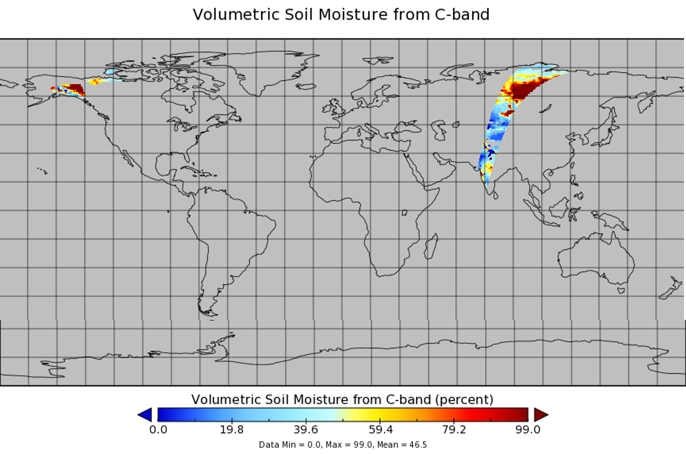
AMSR2/GCOM-W1 surface soil moisture (LPRM) L3 1 day 25 km x 25 km descending V001 (LPRM_AMSR2_D_SOILM3) at GES DISC
National Aeronautics and Space Administration —
AMSR2/GCOM-W1 surface soil moisture (LPRM) L3 1 day 25 km x 25 km descending V001 is a Level 3 (gridded) data set. Its land surface parameters, surface soil moisture,... -
Federal
GEDI L4A Footprint Level Aboveground Biomass Density, Version 2.1
National Aeronautics and Space Administration —
This dataset contains Global Ecosystem Dynamics Investigation (GEDI) Level 4A (L4A) Version 2 predictions of the aboveground biomass density (AGBD; in Mg/ha) and... -
Federal
LBA-ECO LC-39 Modeled Carbon Flux from Deforestation, Mato Grosso, Brazil: 2000-2006 NGDA
National Aeronautics and Space Administration —
This data set contains modeled estimates of carbon flux, biomass, and annual burning emissions across the Brazilian state of Mato Grosso from 2000-2006. The model,... -
Federal
NPP Tropical Forest: Chamela, Mexico, 1982-1995, R1
National Aeronautics and Space Administration —
This data set contains five data files (.txt format). Three data files provide net primary productivity (NPP) estimates for a tropical dry deciduous forest within the... -
Federal
Spectral Reflectance and Ancillary Data, Tundra Transect, North Slope, AK, 2000-2022
National Aeronautics and Space Administration —
This dataset provides visible-near infrared spectral reflectance, descriptions of vegetation cover, surface temperature, the total fraction of absorbed... -
Federal
ABoVE: Photochemical Reflectance and Tree Growth, Brooks Range, Alaska, 2018-2019
National Aeronautics and Space Administration —
This dataset provides simultaneous in-situ measurements of the photochemical reflectance index (PRI) and radial tree growth of selected white spruce trees (Picea... -
Federal
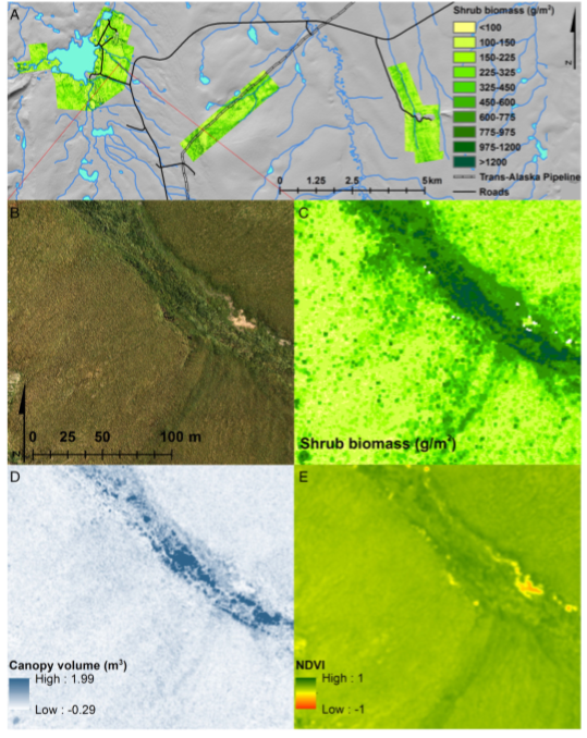
High-Resolution Shrub Biomass and Uncertainty Maps, Toolik Lake Area, Alaska, 2013
National Aeronautics and Space Administration —
This dataset contains estimates for aboveground shrub biomass and uncertainty at high spatial resolution (0.80-m) across three research areas near Toolik Lake,... -
Federal
CMS: LiDAR-derived Biomass, Canopy Height and Cover, Sonoma County, California, 2013
National Aeronautics and Space Administration —
This data set provides estimates of above-ground biomass (AGB), canopy height, and percent tree cover at 30-m spatial resolution for Sonoma County, California, USA,... -
Federal
WindSat/Coriolis surface soil moisture (LPRM) L2 V001 (LPRM_WINDSAT_SOILM2) at GES DISC
National Aeronautics and Space Administration —
WindSat/Coriolis surface soil moisture (LPRM) L2 V001 is a Level 2 (swath) data set. Its land surface parameters, surface soil moisture, land surface (skin)... -
Federal
CMS: Mangrove Canopy Height Estimates from Remote Imagery, Zambezi Delta, Mozambique
National Aeronautics and Space Administration —
This data set provides high resolution canopy height estimates for mangrove forests in the Zambezi Delta, Mozambique, Africa. The estimates were derived from three... -
Federal
CMS: Modeled Net Ecosystem Exchange at 3-hourly Time Steps, 2004-2010
National Aeronautics and Space Administration —
This data set provides global, gridded, model-derived net ecosystem exchange (NEE) of CO2 flux between the land and atmosphere at 3-hourly time steps over seven years...

Official websites use .gov
A
.gov website belongs to an official government
organization in the United States.
Secure .gov websites use HTTPS
A
lock (
) or https:// means you’ve safely connected to
the .gov website. Share sensitive information only on official,
secure websites.