
-
Federal
GEWEX SRB Integrated Product (Rel-4) Ancillary 3-Hourly
National Aeronautics and Space Administration —
GEWEX SRB Integrated Product (Rel-4) Ancillary 3-Hourly contains the global fields of meteorology, clouds and other ancillary data that serves as the inputs to the... -
Federal
GEWEX SRB Integrated Product (Rel-4) Ancillary 3-Hourly Ocean-only
National Aeronautics and Space Administration —
GEWEXSRB_Rel4-IP_Ancillary_3hrly_oceanonly is the Global Energy and Water Exchanges (GEWEX) Surface Radiation Budget (SRB) Integrated Product (Rel-4) Ancillary... -
Federal
MERRA-2 tavgU_2d_glc_Nx: 2d,diurnal,Time-Averaged,Single-Level,Assimilation,Land Ice Surface Diagnostics 0.625 x 0.5 degree V5.12.4 (M2TUNXGLC) at GES DISC
National Aeronautics and Space Administration —
M2TUNXGLC (or tavgU_2d_glc_Nx) is a 2-dimensional monthly diurnal means data collection in Modern-Era Retrospective analysis for Research and Applications version 2... -
Federal
International Satellite Cloud Climatology Project (ISCCP) Stage D1 3-Hourly Cloud Products - Revised Algorithm in Hierarchical Data Format
National Aeronautics and Space Administration —
ISCCP_D1_1 is the International Satellite Cloud Climatology Project (ISCCP) Stage D1 3-Hourly Cloud Products - Revised Algorithm data set in Hierarchical Data Format.... -
Federal
ABoVE: Rain-on-Snow Frequency and Distribution during Cold Seasons, Alaska, 2003-2016 NGDA
National Aeronautics and Space Administration —
This dataset provides maps of rain-on-snow (ROS) events across Alaska for the individual months of November to March 2002-2011 and November to March 2012-2016, and... -
Federal
ABoVE: Last Day of Spring Snow, Alaska, USA, and Yukon Territory, Canada, 2000-2016 NGDA
National Aeronautics and Space Administration —
This dataset provides the last day of spring snow cover for most of Alaska and the Yukon Territory for 2000 through 2016. The data are based on the MODIS daily snow... -
Federal
ABoVE: Passive Microwave-derived Annual Snowoff Date Maps, 1988-2018
National Aeronautics and Space Administration —
This dataset provides annual maps of the snowoff (SO) date from 1988-2018 across Alaska and parts of Far East Russia and northwest Canada at a resolution of 6.25 km.... -
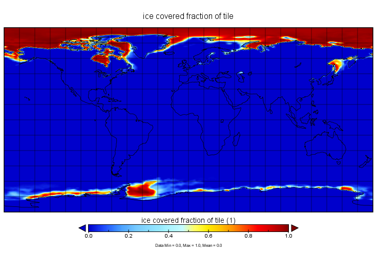
Federal
MERRA-2 tavgM_2d_int_Nx: 2d,Monthly mean,Time-Averaged,Single-Level,Assimilation,Vertically Integrated Diagnostics 0.625 x 0.5 degree V5.12.4 (M2TMNXINT) at GES DISC
National Aeronautics and Space Administration —
M2TMNXINT (or tavgM_2d_int_Nx) is a time-averaged 2-dimensional monthly mean data collection in Modern-Era Retrospective analysis for Research and Applications... -
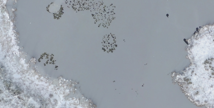
Federal
ABoVE: Aerial Photographs of Frozen Lakes near Fairbanks, Alaska, October 2014
National Aeronautics and Space Administration —
This dataset includes high resolution orthophotographs of 21 lakes in the region of Fairbanks, Alaska, USA. Aerial photographs were taken on October 8, 2014, three... -
Federal
GEWEX SRB Integrated Product (Rel-4) Ancillary 3-Hourly Land-only
National Aeronautics and Space Administration —
GEWEXSRB_Rel4-IP_Ancillary_3hrly_landonly is the Global Energy and Water Exchanges (GEWEX) Surface Radiation Budget (SRB) Integrated Product (Release-4) Ancillary... -
Federal
CARVE: Daily Thaw State of Boreal and Arctic Alaska from AMSR-E and SSM/I, 2003-2014
National Aeronautics and Space Administration —
This data set provides daily 10 km resolution maps of the Alaskan and Arctic Boreal land surface state as either frozen, melting, or thawed. These data are generated... -
Federal
MERRA-2 tavgU_2d_int_Nx: 2d,diurnal,Time-Averaged,Single-Level,Assimilation,Vertically Integrated Diagnostics 0.625 x 0.5 degree V5.12.4 (M2TUNXINT) at GES DISC
National Aeronautics and Space Administration —
M2TUNXINT (or tavgU_2d_int_Nx) is a time-averaged 2-dimensional monthly diurnal means data collection in Modern-Era Retrospective analysis for Research and... -
Federal
MERRA-2 tavg1_2d_int_Nx: 2d,1-Hourly,Time-Averaged,Single-Level,Assimilation,Vertically Integrated Diagnostics 0.625 x 0.5 degree V5.12.4 (M2T1NXINT) at GES DISC
National Aeronautics and Space Administration —
M2T1NXINT (or tavg1_2d_int_Nx) is an hourly time-averaged 2-dimensional data collection in Modern-Era Retrospective analysis for Research and Applications version 2... -
Federal
International Satellite Cloud Climatology Project (ISCCP) Stage D2 Monthly Cloud Products - Revised Algorithm in Hierarchical Data Format
National Aeronautics and Space Administration —
The ISCCP_D2 data set contains monthly, 280 KM equal-area grid data from various polar and geostationary satellites. Climatological Summary Product contents contain... -
Federal
MERRA-2 tavg1_2d_ocn_Nx: 2d,1-Hourly,Time-Averaged,Single-Level,Assimilation,Ocean Surface Diagnostics 0.625 x 0.5 degree V5.12.4 (M2T1NXOCN) at GES DISC
National Aeronautics and Space Administration —
M2T1NXOCN (or tavg1_2d_ocn_Nx) is an hourly time-averaged 2-dimensional data collection in Modern-Era Retrospective analysis for Research and Applications version 2... -
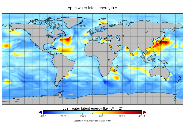
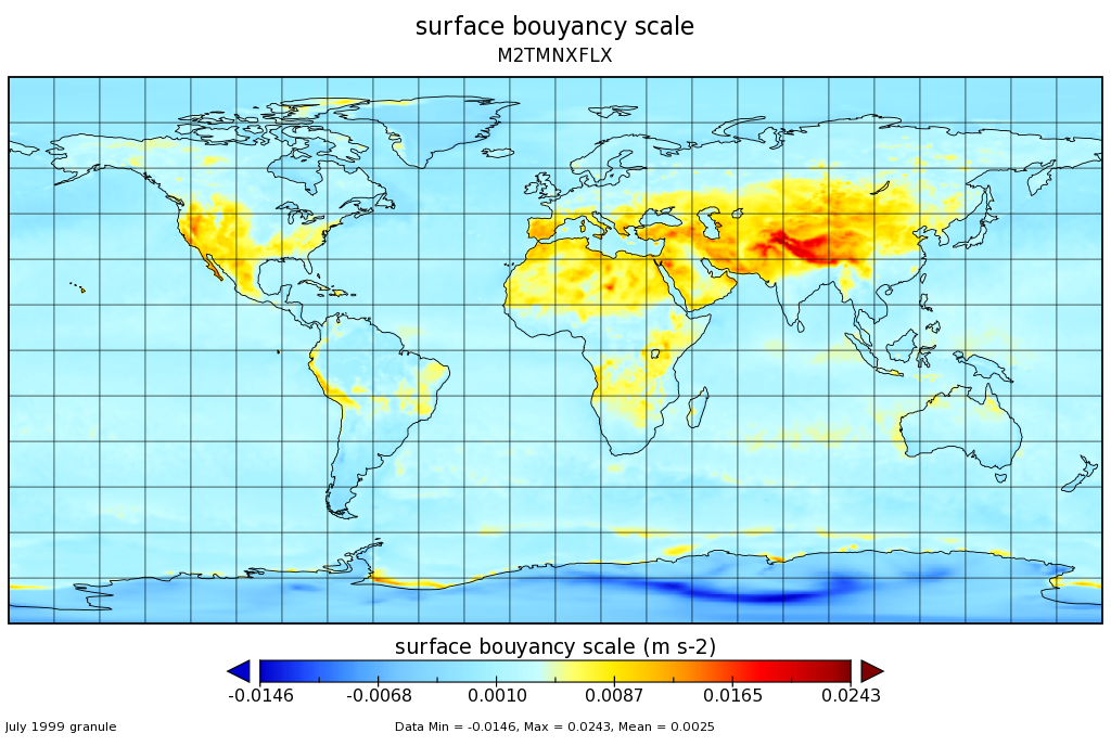
Federal
MERRA-2 tavgM_2d_flx_Nx: 2d,Monthly mean,Time-Averaged,Single-Level,Assimilation,Surface Flux Diagnostics 0.625 x 0.5 degree V5.12.4 (M2TMNXFLX) at GES DISC
National Aeronautics and Space Administration —
M2TMNXFLX (or tavgM_2d_flx_Nx) is a time-averaged 2-dimensional monthly mean data collection in Modern-Era Retrospective analysis for Research and Applications... -
Federal
MERRA-2 tavgU_2d_ocn_Nx: 2d,diurnal,Time-Averaged,Single-Level,Assimilation,Ocean Surface Diagnostics 0.625 x 0.5 degree V5.12.4 (M2TUNXOCN) at GES DISC
National Aeronautics and Space Administration —
M2TUNXOCN (or tavgU_2d_ocn_Nx) is a time-averaged 2-dimensional monthly diurnal means data collection in Modern-Era Retrospective analysis for Research and... -
Federal
Snowmelt Timing Maps Derived from MODIS for North America, Version 2, 2001-2018 NGDA
National Aeronautics and Space Administration —
This data set provides snowmelt timing maps (STMs), cloud interference maps, and a map with the count of calculated snowmelt timing values for North America. The STMs... -
Federal
International Satellite Cloud Climatology Project (ISCCP) Ice Snow Product in Native Data Format
National Aeronautics and Space Administration —
ISCCP_ICESNOW_NAT_1 is the International Satellite Cloud Climatology Project (ISCCP) Ice Snow Product in Native Data Format data set. It is a merged product... -
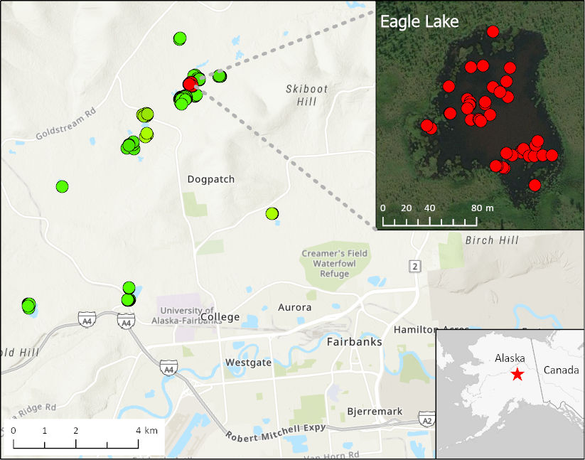
Federal
ABoVE: Methane Ebullition Hotspots in Frozen Lakes near Fairbanks, Alaska, Oct 2014
National Aeronautics and Space Administration —
This dataset includes maps of the locations and number of methane ebullition hotspots in 15 frozen lakes in the southern portion of the Goldstream Valley and the...

Official websites use .gov
A
.gov website belongs to an official government
organization in the United States.
Secure .gov websites use HTTPS
A
lock (
) or https:// means you’ve safely connected to
the .gov website. Share sensitive information only on official,
secure websites.