
-
Federal
2023 Cartographic Boundary File (SHP), Block Group for Arizona, 1:500,000
U.S. Census Bureau, Department of Commerce —
The 2023 cartographic boundary shapefiles are simplified representations of selected geographic areas from the U.S. Census Bureau's Master Address File /... -
Federal
Digital Geologic-GIS Map of Tuzigoot National Monument, Arizona (NPS, GRD, GRI, TUZI, TUZI digital map) adapted from a U.S. Geological Survey Bulletin map by Lehner (1958)
Department of the Interior —
The Unpublished Digital Geologic-GIS Map of Tuzigoot National Monument, Arizona is composed of GIS data layers and GIS tables in a 10.1 file geodatabase... -
Federal
2020 Cartographic Boundary File (KML), Current Place for Arizona, 1:500,000
U.S. Census Bureau, Department of Commerce —
The 2020 cartographic boundary KMLs are simplified representations of selected geographic areas from the U.S. Census Bureau's Master Address File / Topologically... -
Federal
Digital Geologic-GIS Map of Navajo National Monument and Vicinity, Arizona (NPS, GRD, GRI, NAVA, NAVA digital map) adapted from a U.S. Geological Survey Miscellaneous Investigations Series Map by Haynes and Hackman (1978)
Department of the Interior —
The Digital Geologic-GIS Map of Navajo National Monument and Vicinity, Arizona is composed of GIS data layers and GIS tables, and is available in the following GRI-... -
Federal
2023 Cartographic Boundary File (KML), Place for Arizona, 1:500,000
U.S. Census Bureau, Department of Commerce —
The 2023 cartographic boundary KMLs are simplified representations of selected geographic areas from the U.S. Census Bureau's Master Address File / Topologically... -
Federal
2024 Cartographic Boundary File (KML), Block Group for Arizona, 1:500,000
U.S. Census Bureau, Department of Commerce —
The 2024 cartographic boundary KMLs are simplified representations of selected geographic areas from the U.S. Census Bureau's Master Address File / Topologically... -
Federal
Digital Geologic-GIS Map of a portion of Petrified Forest National Park, Arizona (NPS, GRD, GRI, PEFO, PEFO digital map) adapted from a Arizona Geological Survey Contributed Map Series map by Martz, Parker, Thompson and Raucci (2012)
Department of the Interior —
The Digital Geologic-GIS Map of a portion of Petrified Forest National Park, Arizona is composed of GIS data layers and GIS tables, and is available in the following... -
Federal
BLM Natl REA Madrean Archipelago Rapid Ecoregional Assessment (REA) Appendices D-E - December 2014
Department of the Interior —
The Rapid Ecoregional Assessments (REAs) were launched in 2010 to help improve the understanding of existing condition for ecoregions and how conditions may be... -
Federal
Digital Geologic-GIS Map of Coronado National Memorial and Vicinity, Arizona (NPS, GRD, GRI, CORO, CORO digital map) adapted from a U.S. Geological Survey unpublished digital data map by Hon, Gray, Bolm, Dempsey and Pearthree (2007)
Department of the Interior —
The Digital Geologic-GIS Map of Coronado National Memorial and Vicinity, Arizona is composed of GIS data layers and GIS tables, and is available in the following GRI-... -
Federal
2024 Cartographic Boundary File (KML), County Subdivision for Arizona, 1:500,000
U.S. Census Bureau, Department of Commerce —
The 2024 cartographic boundary KMLs are simplified representations of selected geographic areas from the U.S. Census Bureau's Master Address File / Topologically... -
Federal
NOAA/WDS Paleoclimatology - Heinlein fire data from San Francisco Peaks (East) - IMPD USSPE001
National Oceanic and Atmospheric Administration, Department of Commerce —
This archived Paleoclimatology Study is available from the NOAA National Centers for Environmental Information (NCEI), under the World Data Service (WDS) for... -
Federal
2024 Cartographic Boundary File (KML), 119th Congressional Districts for Arizona, 1:500,000
U.S. Census Bureau, Department of Commerce —
The 2024 cartographic boundary KMLs are simplified representations of selected geographic areas from the U.S. Census Bureau's Master Address File / Topologically... -
Federal
Unpublished Digital Geologic Map of Glen Canyon National Recreation Area and Vicinity, Utah, and Arizona (NPS, GRD, GRI, GLCA, GLCA digital map) adapted from Utah Geological Survey digital data and map by Willis and Ehler (2011), and Open-File Report map by Doelling and Willis (1999)
Department of the Interior —
The Unpublished Digital Geologic Map of Glen Canyon National Recreation Area and Vicinity, Utah, Arizona is composed of GIS data layers complete with ArcMap 9.3 layer... -
Federal
2022 Cartographic Boundary File (KML), Current Place for Arizona, 1:500,000
U.S. Census Bureau, Department of Commerce —
The 2022 cartographic boundary KMLs are simplified representations of selected geographic areas from the U.S. Census Bureau's Master Address File / Topologically... -
Federal
2022 Cartographic Boundary File (SHP), Current Census Tract for Arizona, 1:500,000
U.S. Census Bureau, Department of Commerce —
The 2022 cartographic boundary shapefiles are simplified representations of selected geographic areas from the U.S. Census Bureau's Master Address File /... -
Federal
2024 Cartographic Boundary File (SHP), Block Group for Arizona, 1:500,000
U.S. Census Bureau, Department of Commerce —
The 2024 cartographic boundary shapefiles are simplified representations of selected geographic areas from the U.S. Census Bureau's Master Address File /... -
Federal
Digital Geologic-GIS Map of the Bowie Mountain South Quadrangle, Arizona (NPS, GRD, GRI, FOBO, BWMS digital map) adapted from a U.S. Geological Survey Miscellaneous Investigations Series Map by Drewes (1981)
Department of the Interior —
The Digital Geologic-GIS Map of the Bowie Mountain South Quadrangle, Arizona is composed of GIS data layers and GIS tables, and is available in the following GRI-... -
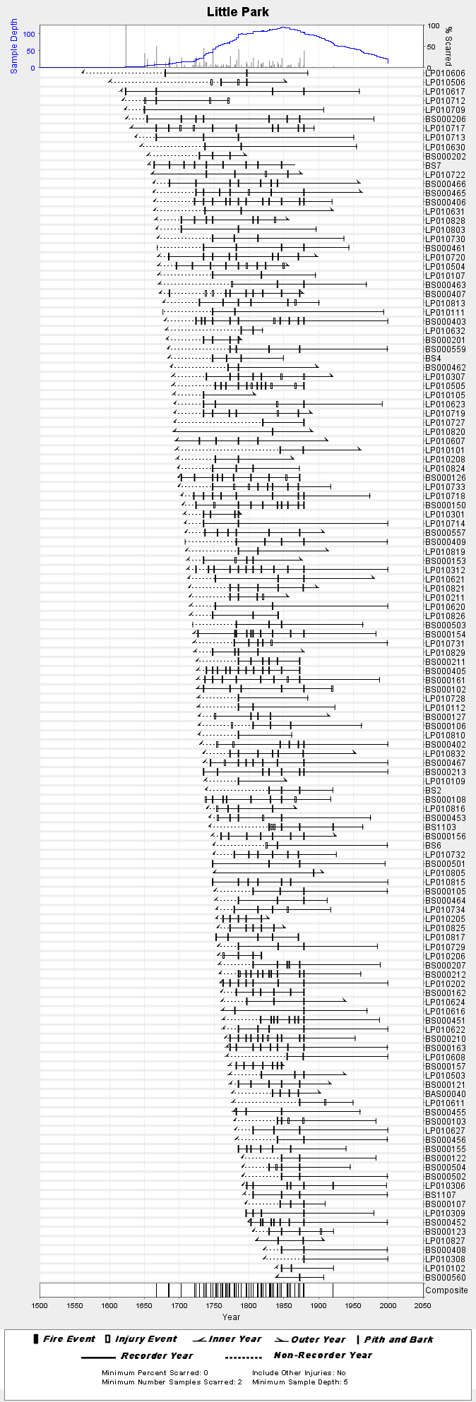
Federal
NOAA/WDS Paleoclimatology - Fulé fire data from Little Park - IMPD USLPK001
National Oceanic and Atmospheric Administration, Department of Commerce —
This archived Paleoclimatology Study is available from the NOAA National Centers for Environmental Information (NCEI), under the World Data Service (WDS) for... -
Federal
2023 Cartographic Boundary File (SHP), Census Tract for Arizona, 1:500,000
U.S. Census Bureau, Department of Commerce —
The 2023 cartographic boundary shapefiles are simplified representations of selected geographic areas from the U.S. Census Bureau's Master Address File /...

Official websites use .gov
A
.gov website belongs to an official government
organization in the United States.
Secure .gov websites use HTTPS
A
lock (
) or https:// means you’ve safely connected to
the .gov website. Share sensitive information only on official,
secure websites.