
-
Federal
High-resolution record of surface seawater carbon dioxide (CO2) content, water temperature, sea surface salinity and other parameters collected in Sitka Harbor, Alaska, USA from 2017-06-01 to 2021-04-27 (NCEI Accession 0247208)
National Oceanic and Atmospheric Administration, Department of Commerce —
This dataset includes measurements of partial pressure of carbon dioxide (pCO2), sea surface salinity, sea surface temperature and other parameters collected in Sitka... -
Federal
Elfin Cove Alaska 1/3 arc-second MHW Coastal Digital Elevation Model
National Oceanic and Atmospheric Administration, Department of Commerce —
NOAA's National Geophysical Data Center (NGDC) is building high-resolution digital elevation models (DEMs) to support individual coastal States as part of the... -
Federal
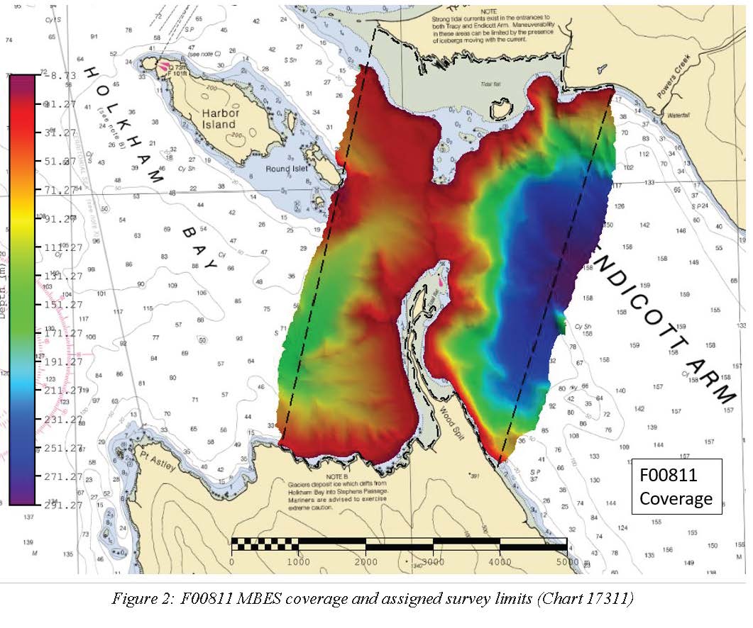
F00811: NOS Hydrographic Survey , 2020-10-10
National Oceanic and Atmospheric Administration, Department of Commerce —
The National Oceanic and Atmospheric Administration (NOAA) has the statutory mandate to collect hydrographic data in support of nautical chart compilation for safe... -
Federal
Dissolved inorganic carbon, total alkalinity, pH, nutrients, and other variables collected from surface only or profile discrete sampling observations using Niskin bottle and other instruments in the Gulf of Alaska region from 2007-05-19 to 2013-07-22 (NCEI Accession 0132049)
National Oceanic and Atmospheric Administration, Department of Commerce —
This dataset includes environmental data from the Gulf of Alaska region. Samples were collected between May 2007 and July 2013. -
Federal
F00736: NOS Hydrographic Survey , 2018-07-03
National Oceanic and Atmospheric Administration, Department of Commerce —
The National Oceanic and Atmospheric Administration (NOAA) has the statutory mandate to collect hydrographic data in support of nautical chart compilation for safe... -
Federal
Elfin Cove, Alaska Tsunami Forecast Grids for MOST Model
National Oceanic and Atmospheric Administration, Department of Commerce —
The Elfin Cove, Alaska Forecast Grids provides bathymetric data strictly for tsunami inundation modeling with the Method of Splitting Tsunami (MOST) model. MOST is a... -
Federal
H11759: NOS Hydrographic Survey , Endicott Arm, Alaska, 2007-11-01
National Oceanic and Atmospheric Administration, Department of Commerce —
The National Oceanic and Atmospheric Administration (NOAA) has the statutory mandate to collect hydrographic data in support of nautical chart compilation for safe... -
Federal
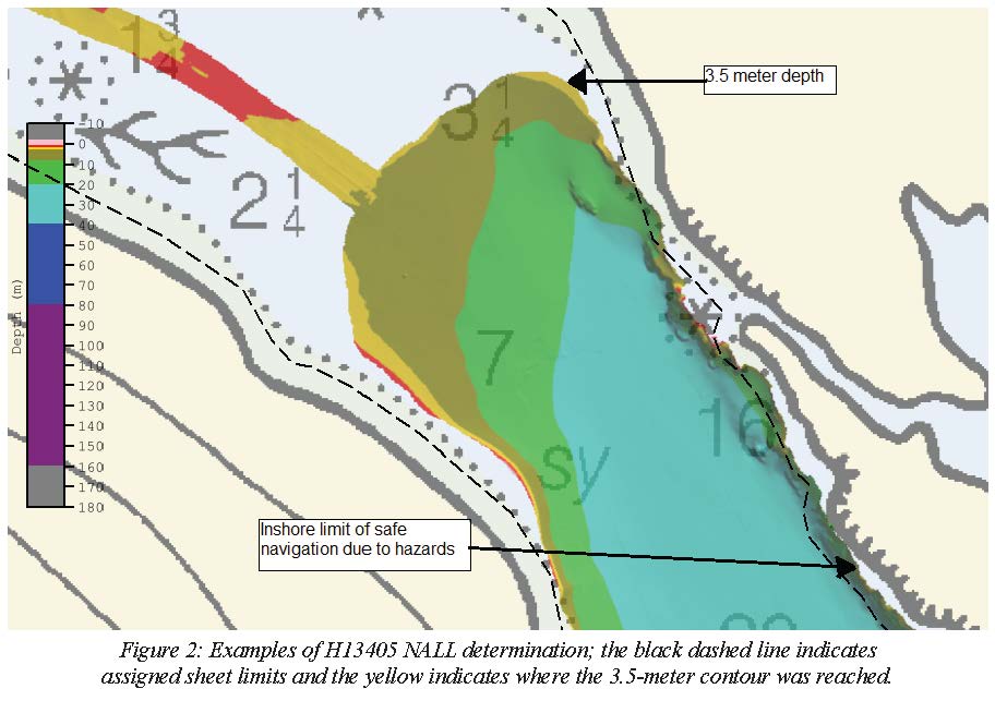
H13405: NOS Hydrographic Survey , 2020-09-13
National Oceanic and Atmospheric Administration, Department of Commerce —
The National Oceanic and Atmospheric Administration (NOAA) has the statutory mandate to collect hydrographic data in support of nautical chart compilation for safe... -
Federal
Alaska's Submerged Heritage 2006
National Oceanic and Atmospheric Administration, Department of Commerce —
In April 2006, Alaska's Office of History and Archaeology (OHA) collaborated with the University of Alaska Fairbanks (UAF), the University of Rhode Island (URI), the... -
Federal
Elfin Cove Alaska 1/3 arc-second MHHW Coastal Digital Elevation Model
National Oceanic and Atmospheric Administration, Department of Commerce —
NOAA's National Geophysical Data Center (NGDC) is building high-resolution digital elevation models (DEMs) to support individual coastal States as part of the... -
Federal
Charter Halibut Limited Access Program
National Oceanic and Atmospheric Administration, Department of Commerce —
This limited access system limits the number of charter vessels that may participate in the guided sport fishery for halibut in area 2C and 3A. NMFS issues a charter... -
Federal
Southeast Alaska 8/3 arc-second MHHW Coastal Digital Elevation Model
National Oceanic and Atmospheric Administration, Department of Commerce —
NOAA's National Geophysical Data Center (NGDC) is building high-resolution digital elevation models (DEMs) to support individual coastal States as part of the... -
Federal
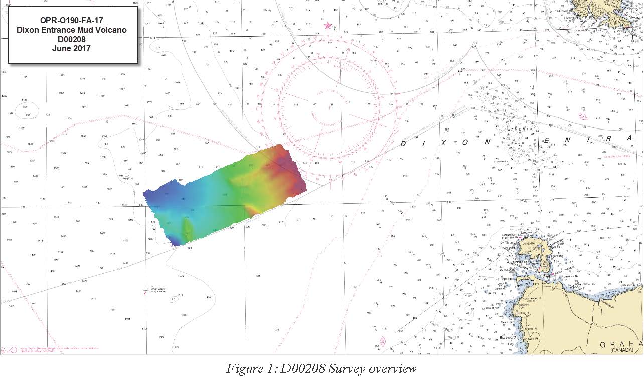
D00208: NOS Hydrographic Survey , 2017-06-17
National Oceanic and Atmospheric Administration, Department of Commerce —
The National Oceanic and Atmospheric Administration (NOAA) has the statutory mandate to collect hydrographic data in support of nautical chart compilation for safe... -
Federal
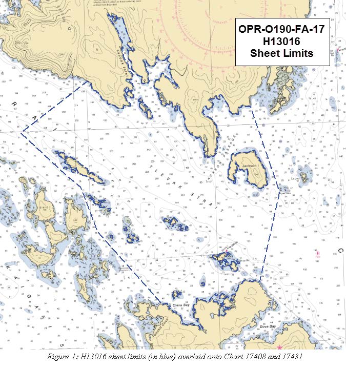
H13016: NOS Hydrographic Survey , 2017-06-21
National Oceanic and Atmospheric Administration, Department of Commerce —
The National Oceanic and Atmospheric Administration (NOAA) has the statutory mandate to collect hydrographic data in support of nautical chart compilation for safe... -
Federal
Port Alexander, Alaska 1/3 arc-second MHW Coastal Digital Elevation Model
National Oceanic and Atmospheric Administration, Department of Commerce —
NOAA's National Geophysical Data Center (NGDC) is building high-resolution digital elevation models (DEMs) to support individual coastal States as part of the... -
Federal
H12973: NOS Hydrographic Survey , 2016-11-17
National Oceanic and Atmospheric Administration, Department of Commerce —
The National Oceanic and Atmospheric Administration (NOAA) has the statutory mandate to collect hydrographic data in support of nautical chart compilation for safe... -
Federal
Southeast Alaska 8 arc-second MHHW Coastal Digital Elevation Model
National Oceanic and Atmospheric Administration, Department of Commerce —
NOAA's National Geophysical Data Center (NGDC) is building high-resolution digital elevation models (DEMs) to support individual coastal States as part of the... -
Federal
F00768: NOS Hydrographic Survey , Lisianski Strait and Vicinity, 2019-05-07
National Oceanic and Atmospheric Administration, Department of Commerce —
The National Oceanic and Atmospheric Administration (NOAA) has the statutory mandate to collect hydrographic data in support of nautical chart compilation for safe... -
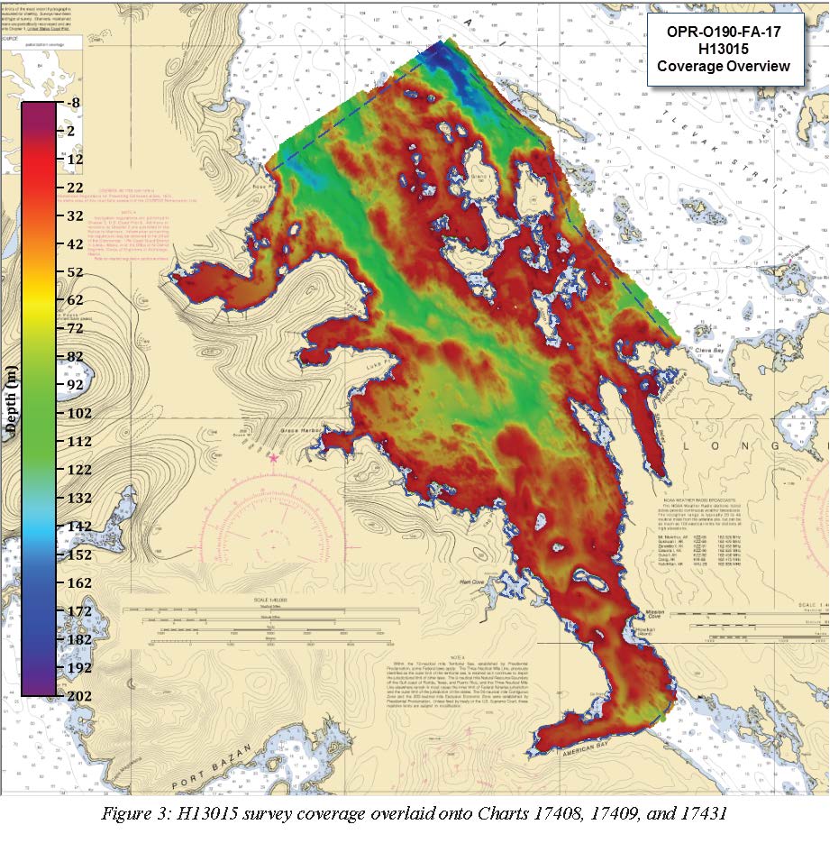
Federal
H13015: NOS Hydrographic Survey , 2017-06-21
National Oceanic and Atmospheric Administration, Department of Commerce —
The National Oceanic and Atmospheric Administration (NOAA) has the statutory mandate to collect hydrographic data in support of nautical chart compilation for safe... -
Federal
H13007: NOS Hydrographic Survey , 2018-05-12
National Oceanic and Atmospheric Administration, Department of Commerce —
The National Oceanic and Atmospheric Administration (NOAA) has the statutory mandate to collect hydrographic data in support of nautical chart compilation for safe...

Official websites use .gov
A
.gov website belongs to an official government
organization in the United States.
Secure .gov websites use HTTPS
A
lock (
) or https:// means you’ve safely connected to
the .gov website. Share sensitive information only on official,
secure websites.