
-
Federal
F00644: NOS Hydrographic Survey , 2014-07-23
National Oceanic and Atmospheric Administration, Department of Commerce —
The National Oceanic and Atmospheric Administration (NOAA) has the statutory mandate to collect hydrographic data in support of nautical chart compilation for safe... -
Federal
Narragansett Bay, RI (M020) Bathymetric Digital Elevation Model (30 meter resolution) Derived From Source Hydrographic Survey Soundings Collected by NOAA
National Oceanic and Atmospheric Administration, Department of Commerce —
Bathymetry for Narragansett Bay was derived from fifteen surveys containing 165,184 soundings. Three older, less accurate, overlapping surveys were entirely omitted,... -
Federal
Near-real-time surface ocean velocities derived from HF-radar stations located along coastal waters of North Slope Alaska, Gulf of Alaska, Puerto Rico/Virgin Islands, eastern U.S./Gulf of America, Hawaii, Great Lakes, and western U.S.
National Oceanic and Atmospheric Administration, Department of Commerce —
This dataset contains near-real-time ocean surface velocities, also known as total vector velocities, derived from high-frequency (HF) radar stations. The velocities... -
Federal
F00642: NOS Hydrographic Survey , 2015-05-15
National Oceanic and Atmospheric Administration, Department of Commerce —
The National Oceanic and Atmospheric Administration (NOAA) has the statutory mandate to collect hydrographic data in support of nautical chart compilation for safe... -
State
Bedrock Geology
State of Connecticut —
Bedrock Geology Set is a 1:50,000-scale, polygon and line feature-based layer describing the solid material that underlies the soil or other unconsolidated material... -
State
Quaternary Geology Features Set
State of Connecticut —
See full Data Guide here. Quaternary Geology Feature Set is 1:24,000-scale data that illustrates the geologic features formed in Connecticut during the Quaternary... -
State
CT Vicinity County Polygon
State of Connecticut —
Connecticut and Vicinity County Boundary data are intended for geographic display of state and county boundaries at statewide and regional levels. Use it to map and... -
State
Quaternary Geology
State of Connecticut —
See full Data Guide here. Quaternary Geology Feature Set is 1:24,000-scale data that illustrates the geologic features formed in Connecticut during the Quaternary... -
Federal
CTD and sound speed profile data acquired in support of hydrographic multibeam surveys to meet NOAA/NOS, Office of Coast Survey charting requirements
National Oceanic and Atmospheric Administration, Department of Commerce —
Multiple sensors are used to acquire sound speed profiles in the survey areas assigned to the ships and navigation response teams. Some vessels have CTDs and acquire... -
State
Connecticut and Vicinity County Boundary Set
State of Connecticut —
Connecticut and Vicinity County Boundary data are intended for geographic display of state and county boundaries at statewide and regional levels. Use it to map and... -
State
Long Island Sound Submerged Cable And Pipeline Areas
State of Connecticut —
The Long Island Sound Submerged Cable and Pipeline Areas layer is a polygon feature-based layer that includes the location of submerged cable and/or pipeline areas in... -
Federal
HB1204: Deep-Sea Corals and Benthic Habitats in Northeast Deepwater Canyons on NOAA Ship Henry Bigelow between 20120703 and 20120718
National Oceanic and Atmospheric Administration, Department of Commerce —
A multi-disciplinary team of scientists on the Henry Bigelow HB1204 mission surveyed and ground-truthed known or suspected deep-sea coral habitats associated with... -
Federal
BLM ES Administrative Unit Office Arc
Department of the Interior —
This polyline feature class represents the spatial extent of active Bureau of Land Management (BLM) Administrative Unit Boundaries at the State, District, and Field... -
Federal
BLM ES Administrative Unit Office Points
Department of the Interior —
This feature-dataset depicts Bureau of Land Management (BLM) office locations. The land areas for higher level administrative units (district and administrative... -
State
Bedrock Geology Contacts
State of Connecticut —
Bedrock Geology Set is a 1:50,000-scale, polygon and line feature-based layer describing the solid material that underlies the soil or other unconsolidated material... -
Federal
F00241: NOS Hydrographic Survey , Southern New England Coast, Conn, Ma., New York and Rhode Island, 1984-06-16
National Oceanic and Atmospheric Administration, Department of Commerce —
The National Oceanic and Atmospheric Administration (NOAA) has the statutory mandate to collect hydrographic data in support of nautical chart compilation for safe... -
State
Northeast State Lines
State of Connecticut —
Northeastern United States State Boundary data are intended for geographic display of state boundaries at statewide and regional levels. Use it to map and label... -
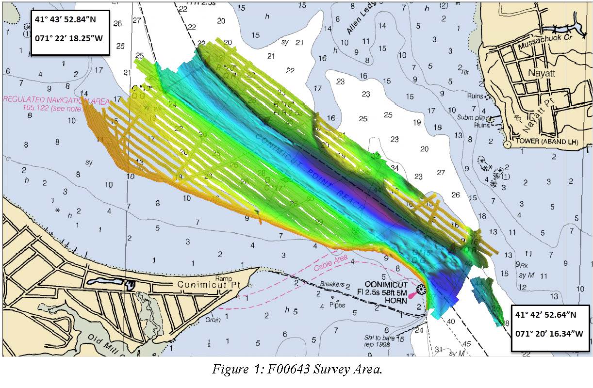
Federal
F00643: NOS Hydrographic Survey , 2014-07-23
National Oceanic and Atmospheric Administration, Department of Commerce —
The National Oceanic and Atmospheric Administration (NOAA) has the statutory mandate to collect hydrographic data in support of nautical chart compilation for safe... -
Federal
Subbottom Profiler Collection for EX1402L1: Gulf of Mexico Mapping and Exploration
National Oceanic and Atmospheric Administration, Department of Commerce —
Knudsen CHIRP 3260 Sub-bottom Profiler raw files (.sgy) -
State
Quaternary Geology Point Features
State of Connecticut —
See full Data Guide here. Quaternary Geology Feature Set is 1:24,000-scale data that illustrates the geologic features formed in Connecticut during the Quaternary...

Official websites use .gov
A
.gov website belongs to an official government
organization in the United States.
Secure .gov websites use HTTPS
A
lock (
) or https:// means you’ve safely connected to
the .gov website. Share sensitive information only on official,
secure websites.
.jpg)