
-
Federal
US EPA Nonattainment Areas and Designations
U.S. Environmental Protection Agency —
This web service contains the following state level layers:Ozone 8-hr (1997 standard), Ozone 8-hr (2008 standard), Lead (2008 standard), SO2 1-hr (2010 standard),... -
Federal
Sea Level Trends: Sea Level Variations of the United States Derived from National Water Level Observation Network Stations NGDA
National Oceanic and Atmospheric Administration, Department of Commerce —
Water level records are a combination of the fluctuations of the ocean and the vertical land motion at the location of the station. Monthly mean sea level (MSL)... -
Federal
Neighborhoods, US, 2017, Zillow, SEGS
U.S. Environmental Protection Agency —
This web service depicts nearly 17,000 neighborhood boundaries in over 650 U.S. cities. Zillow created the neighborhood boundaries and is sharing them with the public... -
Federal
Meteorological Data (including visibility)
National Oceanic and Atmospheric Administration, Department of Commerce —
The National Ocean Service (NOS) maintains a long-term database containing data from active and historic stations installed all over the United States and U.S.... -
Federal
Maritime Limits and Boundaries of United States of America NGDA
National Oceanic and Atmospheric Administration, Department of Commerce —
NOAA is responsible for depicting on its nautical charts the limits of the 12 nautical mile Territorial Sea, 24 nautical mile Contiguous Zone, and 200 nautical mile... -
University
New Mexico Federal Lands
Earth Data Analysis Center, University of New Mexico —
This map layer consists of federally owned or administered lands of the United States, Puerto Rico, and the U.S. Virgin Islands. Only areas of 640 acres or more are... -
Federal
Geoid Height and Deflections of the Vertical Models NGDA
National Oceanic and Atmospheric Administration, Department of Commerce —
In Gauss' words, the geoid is "the mathematical figure of the Earth". This figure is an equipotential surface coincident with the idealized mean sea surface. The... -
Federal
TIGER/Line Shapefile, 2019, state, Puerto Rico, Current Subbarrio (Subminor Civil Division)
U.S. Census Bureau, Department of Commerce —
The TIGER/Line shapefiles and related database files (.dbf) are an extract of selected geographic and cartographic information from the U.S. Census Bureau's Master... -
Federal
NOAA Next Generation Radar (NEXRAD) Level 3 Products
National Oceanic and Atmospheric Administration, Department of Commerce —
This dataset consists of Level 3 weather radar products collected from Next-Generation Radar (NEXRAD) stations located in the contiguous United States, Alaska,... -
Federal
Airborne Gravity Data - Gravity for the Redefinition of the American Vertical Datum (GRAV-D) NGDA
National Oceanic and Atmospheric Administration, Department of Commerce —
Gravity for the Re-definition of the American Vertical Datum (GRAV-D) is a project initiated by NOAA's National Geodetic Survey to collect and monitor gravity data... -
Federal
NCCOS Assessment: Benthic Habitat Map for the Insular Shelf South of St. Thomas and St. John, U.S. Virgin Islands (NCEI Accession 0170098)
National Oceanic and Atmospheric Administration, Department of Commerce —
The dataset describes the spatial distribution of benthic habitats on the insular shelf south of St. Thomas and St. John, U.S. Virgin Islands. These benthic habitats... -
Federal
R4FRS CERCLIS
U.S. Environmental Protection Agency —
To improve public health and the environment, the United States Environmental Protection Agency (USEPA) collects information about facilities, sites, or places... -
Federal
Physical Oceanographic (Water Temperature and Conductivity) Data
National Oceanic and Atmospheric Administration, Department of Commerce —
NOAA's Center for Operational Oceanographic Products and Services (CO-OPS) is the authoritative source for accurate, reliable, and timely data on tides, water levels,... -
Federal
U.S. Hourly Climate Normals (1981-2010)
National Oceanic and Atmospheric Administration, Department of Commerce —
The U.S. Hourly Climate Normals for 1981 to 2010 are 30-year averages of meteorological parameters for thousands of U.S. stations located across the 50 states, as... -
Federal
US EPA Nonattainment Areas and Designations - Carbon Monoxide (1990 NAAQS) - Web Service Layer
U.S. Environmental Protection Agency —
This web service layer, Carbon Monoxide (1990 NAAQS), displays identified state level areas where carbon monoxide pollution has not met the National Ambient Air... -
Federal
The Coral Reef Temperature Anomaly Database (CoRTAD) Version 4 - Global, 4 km Sea Surface Temperature and Related Thermal Stress Metrics for 1981-10-31 to 2010-12-31 (NODC Accession 0087989)
National Oceanic and Atmospheric Administration, Department of Commerce —
The Coral Reef Temperature Anomaly Database (CoRTAD) is a collection of sea surface temperature (SST) and related thermal stress metrics, developed specifically for... -
Federal
Near-Real Time Surface Ocean Velocity, Puerto Rico and the Virgin Islands, 2km Resolution, 2025-present
National Oceanic and Atmospheric Administration, Department of Commerce —
Surface ocean velocities estimated from High Frequency (HF)-Radar are representative of the upper 1.0 meters of the ocean. The main objective of near-real time... -
Federal
NOAA Tidal Currents for Coastal, Estuaries and Great Lakes (non-tidal) regions
National Oceanic and Atmospheric Administration, Department of Commerce —
Since the late-1800s, NOAAâs Center for Operational Oceanographic Products and Services (CO-OPS) and its predecessors have been collecting, analyzing and... -
Federal
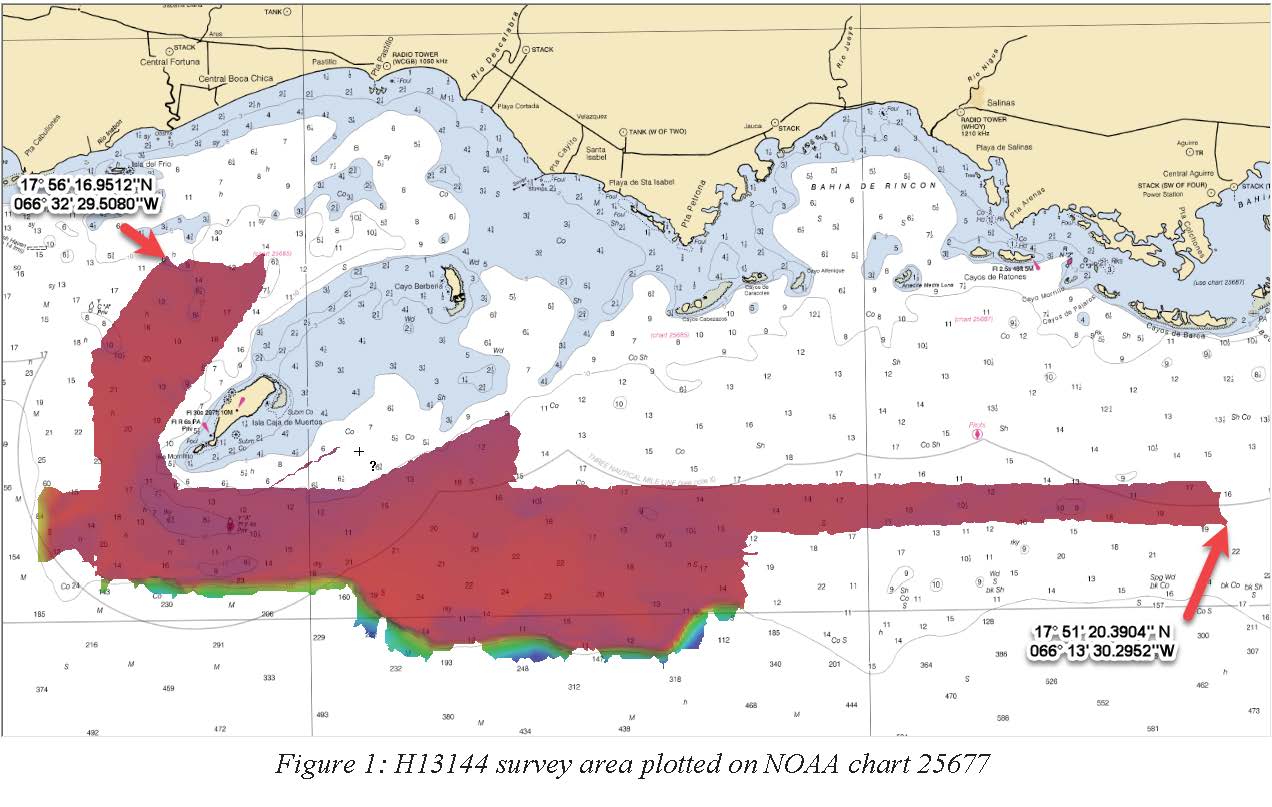
H13144: NOS Hydrographic Survey , 2018-11-02
National Oceanic and Atmospheric Administration, Department of Commerce —
The National Oceanic and Atmospheric Administration (NOAA) has the statutory mandate to collect hydrographic data in support of nautical chart compilation for safe...

Official websites use .gov
A
.gov website belongs to an official government
organization in the United States.
Secure .gov websites use HTTPS
A
lock (
) or https:// means you’ve safely connected to
the .gov website. Share sensitive information only on official,
secure websites.