
-
Federal
Monitoring Trends in Burn Severity Burned Area Boundaries (Feature Layer)
Department of Agriculture —
The Monitoring Trends in Burn Severity (MTBS) Program assesses the frequency, extent, and magnitude (size and severity) of all large wildland fires (including... -
Federal
BLM Natl AIM TerrADat Hub
Department of the Interior —
This feature class includes monitoring data collected nationally to understand the status, condition, and trend of resources on BLM lands. It focuses on the BLM... -
Federal
Alaska Native Villages
Department of the Interior —
This dataset contains the tribal leadership locations as well as contact information for all 227 Alaska Native Villages. For a full list of Tribes in Alaska please... -
Federal
Near-real-time surface ocean velocities derived from HF-radar stations located along coastal waters of North Slope Alaska, Gulf of Alaska, Puerto Rico/Virgin Islands, eastern U.S./Gulf of America, Hawaii, Great Lakes, and western U.S.
National Oceanic and Atmospheric Administration, Department of Commerce —
This dataset contains near-real-time ocean surface velocities, also known as total vector velocities, derived from high-frequency (HF) radar stations. The velocities... -
Federal
H12829: NOS Hydrographic Survey , 2015-08-12
National Oceanic and Atmospheric Administration, Department of Commerce —
The National Oceanic and Atmospheric Administration (NOAA) has the statutory mandate to collect hydrographic data in support of nautical chart compilation for safe... -
Federal
Percent Change in Annual Precipitation (Alaska) (Image Service)
Department of Agriculture —
The National Forest Climate Change Maps project was developed to meet the need of National Forest managers for information on projected climate changes at a scale... -
Federal
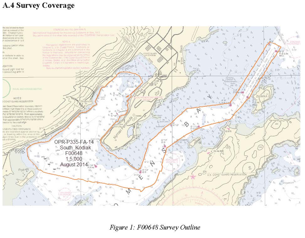
F00648: NOS Hydrographic Survey , 2014-08-18
National Oceanic and Atmospheric Administration, Department of Commerce —
The National Oceanic and Atmospheric Administration (NOAA) has the statutory mandate to collect hydrographic data in support of nautical chart compilation for safe... -
Federal
BLM Natl AIM Riparian and Wetland Indicators Hub
Department of the Interior —
This feature class includes monitoring data collected nationally to understand the status, condition, and trend of resources on BLM lands. Data are collected in... -
Federal
Raw Knudsen 320B/R CHIRP Subbottom Profiler - CHIRP Subbottom Profiler Data for the Arctic Ocean ECS Survey
National Oceanic and Atmospheric Administration, Department of Commerce —
Knudsen 320B/R CHIRP Subbottom Profiler - CHIRP Subbottom Profiler data were collected in Raw Knudsen SEG-Y Datagram format. -
Federal
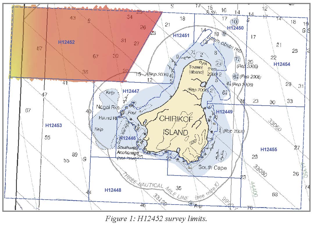
H12452: NOS Hydrographic Survey , Chirikof Island and Vicinity, AK, 2012-08-22
National Oceanic and Atmospheric Administration, Department of Commerce —
The National Oceanic and Atmospheric Administration (NOAA) has the statutory mandate to collect hydrographic data in support of nautical chart compilation for safe... -
Federal
Terrestrial Condition Assessment (TCA) Alaska Tree Mortality 0 to 5 years (Image Service)
Department of Agriculture —
Direct Download (Raster Data Gateway) Objective: Characterize recent impacts to terrestrial ecosystems due to outbreaks of major invasive, non-native, and native... -
Federal
Raw ODEC Bathy2000 CHIRP Subbottom Profiler - CHIRP High-Resolution Seismic Profile Data for the Chukchi Cap and Arctic Ocean
National Oceanic and Atmospheric Administration, Department of Commerce —
ODEC Bathy2000 CHIRP subbottom profiler - CHIRP high-resolution Seismic Profile data were collected in Raw ODEC Bathy2000 CHIRP dat Datagram Format. -
Federal
H13564: NOS Hydrographic Survey , 2022-06-29
National Oceanic and Atmospheric Administration, Department of Commerce —
The National Oceanic and Atmospheric Administration (NOAA) has the statutory mandate to collect hydrographic data in support of nautical chart compilation for safe... -
Federal
H13446: NOS Hydrographic Survey , 2021-06-19
National Oceanic and Atmospheric Administration, Department of Commerce —
The National Oceanic and Atmospheric Administration (NOAA) has the statutory mandate to collect hydrographic data in support of nautical chart compilation for safe... -
Federal
H13919: NOS Hydrographic Survey , 2024-10-10
National Oceanic and Atmospheric Administration, Department of Commerce —
The National Oceanic and Atmospheric Administration (NOAA) has the statutory mandate to collect hydrographic data in support of nautical chart compilation for safe... -
Federal
H13924: NOS Hydrographic Survey , 2024-10-18
National Oceanic and Atmospheric Administration, Department of Commerce —
The National Oceanic and Atmospheric Administration (NOAA) has the statutory mandate to collect hydrographic data in support of nautical chart compilation for safe... -
Federal
H13444: NOS Hydrographic Survey , 2021-07-14
National Oceanic and Atmospheric Administration, Department of Commerce —
The National Oceanic and Atmospheric Administration (NOAA) has the statutory mandate to collect hydrographic data in support of nautical chart compilation for safe... -
Federal
H13668: NOS Hydrographic Survey , 2022-10-12
National Oceanic and Atmospheric Administration, Department of Commerce —
The National Oceanic and Atmospheric Administration (NOAA) has the statutory mandate to collect hydrographic data in support of nautical chart compilation for safe... -
Federal
BLM Natl AIM LMF Hub
Department of the Interior —
This dataset was created to monitor the status, condition and trend of national BLM resources in accordance with BLM policies. It focuses on the BLM terrestrial core... -
Federal
Monitoring Trends in Burn Severity (MTBS) Conterminous United States
Department of Agriculture —
The Monitoring Trends in Burn Severity (MTBS) Program assesses the frequency, extent, and magnitude (size and severity) of all large wildland fires (wildfires and...

Official websites use .gov
A
.gov website belongs to an official government
organization in the United States.
Secure .gov websites use HTTPS
A
lock (
) or https:// means you’ve safely connected to
the .gov website. Share sensitive information only on official,
secure websites.