
-
Federal
Shoreline Data Rescue Project of Southern California, CA1934A NGDA
National Oceanic and Atmospheric Administration, Department of Commerce —
These data were automated to provide an accurate high-resolution historical shoreline of Southern California suitable as a geographic information system (GIS) data... -
Federal
H13197: NOS Hydrographic Survey , 2018-10-29
National Oceanic and Atmospheric Administration, Department of Commerce —
The National Oceanic and Atmospheric Administration (NOAA) has the statutory mandate to collect hydrographic data in support of nautical chart compilation for safe... -
Federal
San Diego, California 1/3 Arc-second MHW Coastal Digital Elevation Model
National Oceanic and Atmospheric Administration, Department of Commerce —
NOAA's National Geophysical Data Center (NGDC) is building high-resolution digital elevation models (DEMs) for select U.S. coastal regions. These integrated... -
Federal
San Diego, California Tsunami Forecast Grids for MOST Model
National Oceanic and Atmospheric Administration, Department of Commerce —
The San Diego, California Forecast Model Grids provides bathymetric data strictly for tsunami inundation modeling with the Method of Splitting Tsunami (MOST) model.... -
Federal
Olympic Coast National Marine Sanctuary - grab110_0204 - Sediment grabs within survey area 110_0204 taken from USGS usSeabed
National Oceanic and Atmospheric Administration, Department of Commerce —
Over the past 50 years there has been an explosion in scientific interest, research effort, and information gathered on the geologic sedimentary character of the... -
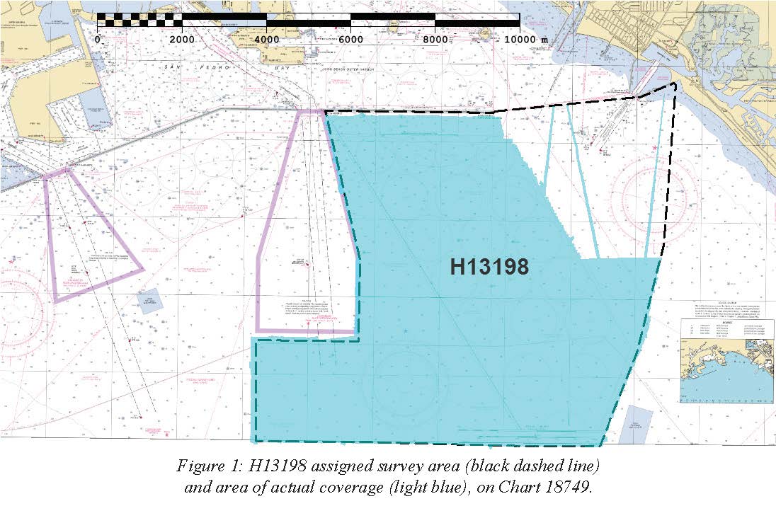
Federal
H13198: NOS Hydrographic Survey , 2018-10-29
National Oceanic and Atmospheric Administration, Department of Commerce —
The National Oceanic and Atmospheric Administration (NOAA) has the statutory mandate to collect hydrographic data in support of nautical chart compilation for safe... -
Federal
NOAA's Coastal Protection and Restoration Division: Watershed Database and Mapping Projects
National Oceanic and Atmospheric Administration, Department of Commerce —
Protection and restoration of coastal watersheds requires the synthesis of complex environmental issues. Contaminated site remediation, dredging and disposal of... -
Federal
Los Angeles, California Tsunami Forecast Grids for MOST Model
National Oceanic and Atmospheric Administration, Department of Commerce —
The Los Angeles, California Forecast Model Grids provides bathymetric data strictly for tsunami inundation modeling with the Method of Splitting Tsunami (MOST) model.... -
Federal
San Diego, California 1/3 Arc-second NAVD 88 Coastal Digital Elevation Model
National Oceanic and Atmospheric Administration, Department of Commerce —
NOAA's National Geophysical Data Center (NGDC) is building high-resolution digital elevation models (DEMs) for select U.S. coastal regions. These integrated... -
Federal
Santa Monica, California Tsunami Forecast Grids for MOST Model
National Oceanic and Atmospheric Administration, Department of Commerce —
The Santa Monica, California Forecast Model Grids provides bathymetric data strictly for tsunami inundation modeling with the Method of Splitting Tsunami (MOST)... -
Federal
Santa Monica, California 1/3 arc-second MHW Coastal Digital Elevation Model
National Oceanic and Atmospheric Administration, Department of Commerce —
NOAA's National Geophysical Data Center (NGDC) is building high-resolution digital elevation models (DEMs) for select U.S. coastal regions. These integrated... -
Federal
Santa Monica, California 1/3 arc-second NAVD 88 Coastal Digital Elevation Model
National Oceanic and Atmospheric Administration, Department of Commerce —
NOAA's National Geophysical Data Center (NGDC) is building high-resolution digital elevation models (DEMs) for select U.S. coastal regions. These integrated...

Official websites use .gov
A
.gov website belongs to an official government
organization in the United States.
Secure .gov websites use HTTPS
A
lock (
) or https:// means you’ve safely connected to
the .gov website. Share sensitive information only on official,
secure websites.