
-
Federal
Delta-X: AirSWOT L2 Geocoded Water Surface Elevation, MRD, Louisiana, 2021, Version 2
National Aeronautics and Space Administration —
This dataset contains Level 2 (L2) AirSWOT geocoded products, including estimated water surface elevation. The AirSWOT instrument is a Ka-band interferometer and for... -
Federal
LBA-ECO ND-01 Watershed Deforestation from Landsat TM Series, Rondonia, Brazil: 1999
National Aeronautics and Space Administration —
This data set provides estimates of watershed deforestation, as a proportion of the total area of watersheds, in Rondonia, Brazil for 1999. Deforestation maps were... -
Federal
Delta-X: UAVSAR L1 Single Look Complex (SLC) Stack Products, MRD, Louisiana, 2021
National Aeronautics and Space Administration —
This dataset contains UAVSAR Level 1 (L1) Single Look Complex (SLC) stack products for Delta-X flight lines acquired during 2021-03-27 to 2021-04-18 (spring) and... -
Federal
Arctic Vegetation Plots in Northern NWT and YT, Canada, 1965-1966
National Aeronautics and Space Administration —
This dataset provides vegetation, soil, and plot characteristics for 154 study plots located at three sites across the Richardson Mountains, Northwest Territories... -
Federal
MODIS/Aqua Water Reservoir Monthly L3 Global V061 NGDA
National Aeronautics and Space Administration —
The Aqua Moderate Resolution Imaging Spectroradiometer (MODIS) Water Reservoir Monthly Level 3 (L3) Global (MYD28C3) Version 6.1 product provides current data for 151... -
Federal
Global Soil Profile Data (ISRIC-WISE)
National Aeronautics and Space Administration —
The ISRIC-WISE International soil profile data set consists of a homogenized, global set of 1,125 soil profiles for use by global modelers. These profiles provided... -
Federal
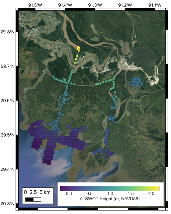
Delta-X: AirSWOT L3 Water Surface Elevations, MRD, Louisiana, 2021
National Aeronautics and Space Administration —
This dataset contains water surface elevations at selected point locations generated from the AirSWOT data collected during the Spring and Fall 2021 Delta-X... -
Federal
ISLSCP II HYDRO1k Elevation-derived Products
National Aeronautics and Space Administration —
This data set contains coarse scale elevation and elevation-based parameters at 1.0 and 0.5-degree spatial resolutions that were developed to support a wide variety... -
Federal
ISLSCP II River Routing Data (STN-30p)
National Aeronautics and Space Administration —
The Simulated Topological Network (STN-30p) data set provides the large-scale hydrological modeling community an accurate representation of the global river system at... -
Federal
Pre-Delta-X: L1 UAVSAR Single Look Complex and Interferograms, MRD, LA, USA, 2016
National Aeronautics and Space Administration —
This Level 1 (L1) dataset includes single look complex (SLC) stack products and co-registered interferograms in the HH (horizontal transmit and horizontal receive)... -
Federal
LBA-ECO CD-06 Biogeochemistry of Ji-Parana River and Tributaries, Brazil: 1999-2003
National Aeronautics and Space Administration —
This data set provides spatially extensive and temporally intensive surveys of the river biogeochemistry of the Ji-Parana River Basin in Western Amazonia, Rondonia,... -
Federal
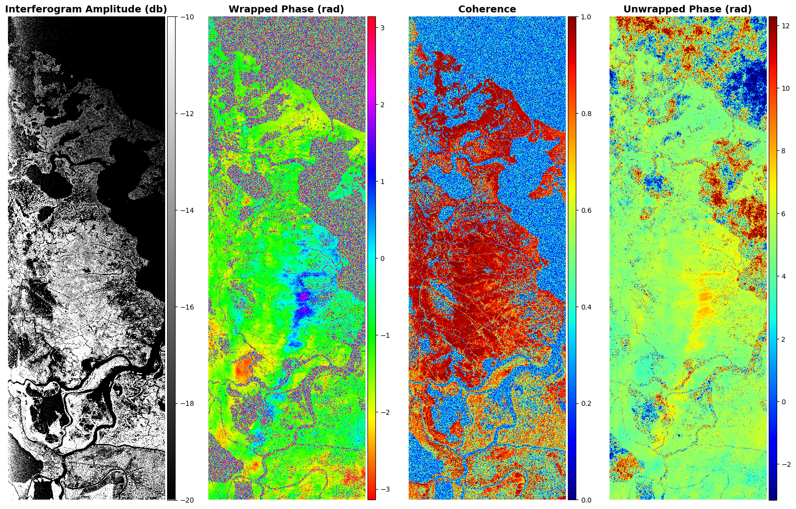
Delta-X: UAVSAR L2 Interferometric Products, MRD, Louisiana, 2021
National Aeronautics and Space Administration —
This dataset contains georeferenced UAVSAR Level 2 (L2) interferometric products for Delta-X flight lines acquired during the spring (2021-03-27 to 2021-04-18) and... -
Federal
Delta-X: UAVSAR L1B Interferometric Products, MRD, Louisiana, 2021
National Aeronautics and Space Administration —
This dataset contains UAVSAR Level 1B (L1B) interferometric products for Delta-X flight lines acquired during the 2021 Spring (2021-03-27 to 2021-04-18) and Fall... -
Federal
CO2 and CH4 Fluxes from Waterbodies, Yukon-Kuskokwim Delta, Alaska, 2016-2019
National Aeronautics and Space Administration —
This dataset provides estimates of carbon dioxide (CO2) and methane (CH4) diffusive fluxes from waterbodies, and watershed landcover data for the central-interior of... -
Federal
MODIS/Terra Water Reservoir 8-Day L3 Global V061 NGDA
National Aeronautics and Space Administration —
The Terra Moderate Resolution Imaging Spectroradiometer (MODIS) Water Reservoir 8-Day Level 3 (L3) Global (MOD28C2) Version 6.1 product provides current data for 151... -
Federal
ASTER Global Water Bodies Database NetCDF V001 NGDA
National Aeronautics and Space Administration —
The ASTER Global Water Bodies Database (ASTWBD) Version 1 data product provides global coverage of water bodies larger than 0.2 square kilometers at a spatial... -
Federal
MODIS/Aqua Water Reservoir 8-Day L3 Global V061 NGDA
National Aeronautics and Space Administration —
The Aqua Moderate Resolution Imaging Spectroradiometer (MODIS) Water Reservoir 8-Day Level 3 (L3) Global (MYD28C2) Version 6.1 product provides current data for 151... -
Federal
ASTER Global Water Bodies Database Attributes NetCDF V001 NGDA
National Aeronautics and Space Administration —
The ASTER Global Water Bodies Database (ASTWBD) Version 1 data product provides global coverage of water bodies larger than 0.2 square kilometers at a spatial... -
Federal
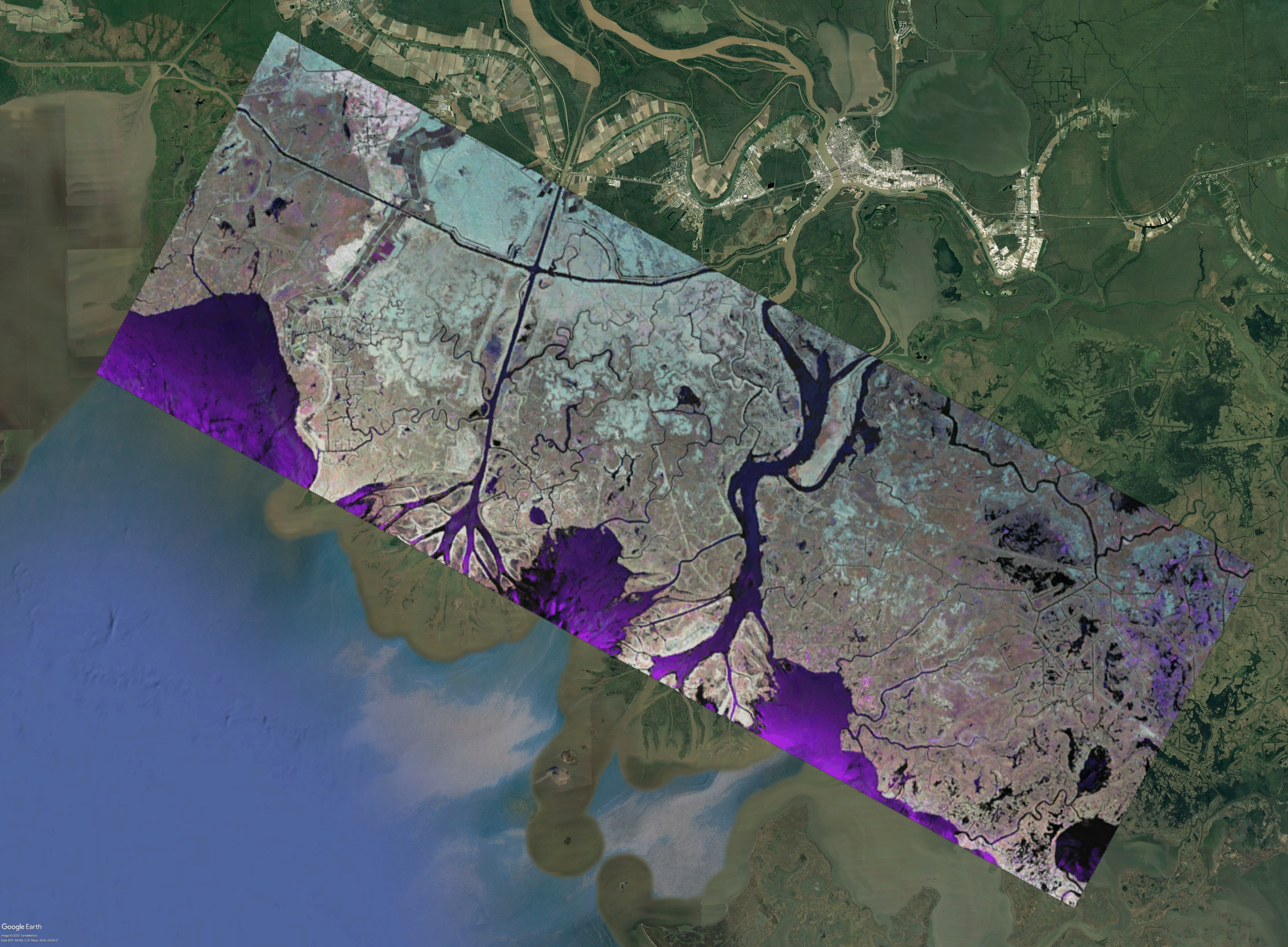
ABoVE: AirSWOT Radar, Orthomosaic, and Water Masks, Yukon Flats Basin, Alaska, 2015
National Aeronautics and Space Administration —
This dataset provides NASA AirSWOT Ka-band (35.75 GHz) radar interferometry data products for water surface elevation (WSE), a derived color-infrared (CIR) digital... -
Federal
LBA Regional Boundary for the Amazon and Tocantins River Basins, 5-min
National Aeronautics and Space Administration —
This data set is an expanded version of the Costa et al. (2000) data set and consists of a single grid with values of 1 for cells within the basins and 0 for cells...

Official websites use .gov
A
.gov website belongs to an official government
organization in the United States.
Secure .gov websites use HTTPS
A
lock (
) or https:// means you’ve safely connected to
the .gov website. Share sensitive information only on official,
secure websites.