
-
Federal
BOREAS/SRC AMS Suite A Surface Meteorological and Radiation Data: 1995
National Aeronautics and Space Administration —
Contains the data collected in 1995 by the AMS suite A instrument set operated by SRC and provided to BORIS. -
Federal
BOREAS RSS-02 Level-1b ASAS Image Data: At-sensor Radiance in BSQ Format
National Aeronautics and Space Administration —
The BOREAS RSS-02 team used the ASAS instrument, mounted on the NASA C-130 aircraft, to create at-sensor radiance images of various sites as a function of spectral... -
Federal
Fast Longwave And SHortwave Fluxes (FLASHflux) NOAA-20 Clouds and Radiative Swath (SSF) Version1B
National Aeronautics and Space Administration —
FLASH_SSF_NOAA20-FM6-VIIRS_Version1B data are near real-time CERES observed TOA fluxes, clouds, and parameterized surface fluxes, not officially calibrated. The Fast... -
Federal
BOREAS Landsat MSS Imagery: Digital Counts
National Aeronautics and Space Administration —
A set of MSS images from Landsat satellites 1, 2, 4 and 5 covering the dates of 21-Aug-1972 to 05-Sep-1988. -
Federal
BOREAS Elevation Contours over the NSA and SSA ARC/Info Generate Format
National Aeronautics and Space Administration —
Elevation contours over the NSA and SSA in ARC/Info Generate Format. Data cover portions of the BOREAS Northern Study Area (NSA) and Southern Study Area (SSA) and are... -
Federal
BOREAS Landsat TM Level-3p Imagery: Geocoded and Scaled At-Sensor Radiance
National Aeronautics and Space Administration —
For BOREAS, the level-3p Landsat TM data were used to supplement the level-3s Landsat TM products. Along with the other remotely sensed images, the Landsat TM images... -
Federal
MODIS (Aqua/Terra) Cloud Properties Level 3 daily, 1x1 degree grid NGDA
National Aeronautics and Space Administration —
The combined MODIS (Aqua/Terra) Cloud Properties Level 3 daily, 1x1 degree grid product represents a new addition that is especially geared to facilitate climate... -
Federal
MODIS (Aqua/Terra) Cloud Properties Level 3 monthly, 1x1 degree grid NGDA
National Aeronautics and Space Administration —
The combined MODIS (Aqua/Terra) Cloud Properties Level 3 monthly, 1x1 degree grid product represents a new addition that is especially geared to facilitate climate... -
Federal
BOREAS RSS-18 Level 1b AVIRIS At-Sensor Radiance Imagery
National Aeronautics and Space Administration —
Data were acquired for BOREAS with NASA's Airborne Visible/Infrared Imaging Spectrometer (AVIRIS). This optical sensor measures images that consist of spectra from... -
Federal
TROPICS03 L2B Atmospheric Vertical Temperature and Moisture Profiles (AVTP, AVMP) V0.2
National Aeronautics and Space Administration —
The "Time-Resolved Observations of Precipitation structure and storm Intensity with a Constellation of Smallsats" (TROPICS) mission has a goal of providing nearly... -
Federal
BOREAS SERM Forest Cover Data of Saskatchewan in Vector Format
National Aeronautics and Space Administration —
A condensed forest cover type digital map of Saskatchewan and is a product of the Saskatchewan Environment and Resource Management, Forestry Branch-Inventory Unit... -
Federal
BOREAS RSS-15 SIR-C and TM Biomass and Landcover Maps of the NSA and SSA
National Aeronautics and Space Administration —
The RSS-15 team conducted an investigation using SIR-C , X-SAR and Landsat TM data for estimating total above-ground dry biomass for the SSA and NSA modeling grids... -
Federal
BOREAS RSS-10 TOMS Circumpolar One-Degree PAR Images
National Aeronautics and Space Administration —
The BOREAS RSS-10 team investigated the magnitude of daily, seasonal, and yearly variations of PAR from ground and satellite observations. This data set contains... -
Federal
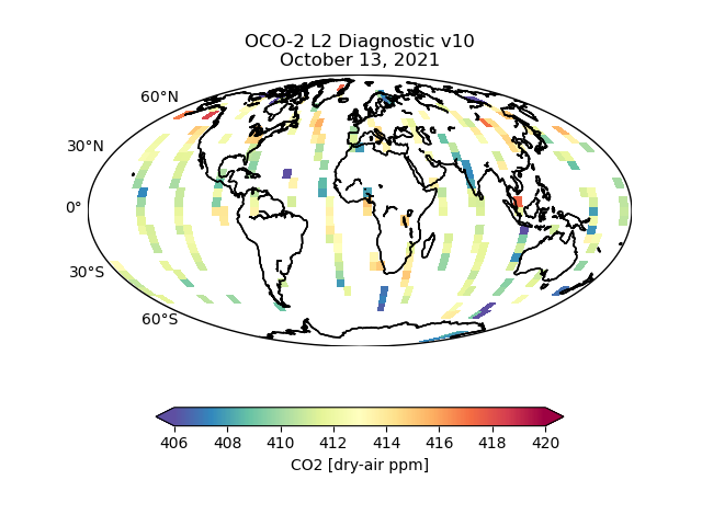
OCO-2 Level 2 geolocated XCO2 retrieval results and algorithm diagnostic information V11.2 (OCO2_L2_Diagnostic) at GES DISC
National Aeronautics and Space Administration —
Version 11.2 is the current version of the data set. Older versions will no longer be available and are superseded by Version 11.2. The Orbiting Carbon Observatory is... -
Federal
BOREAS RSS-14 GOES-8 Level-1 Visible, Infrared and Water Vapor Images
National Aeronautics and Space Administration —
The level-1 BOREAS GOES-8 images are raw data values collected by RSS-14 personnel at FSU and delivered to BORIS. The data cover 14-Jul-1995 to 21-Sep-1995 and... -
Federal
BOREAS RSS-19 1994 CASI At-Sensor Radiance and Reflectance Images
National Aeronautics and Space Administration —
CASI images from the Chieftain Navaho aircraft taken in order to observe the seasonal change in the radiometric reflectance properties of the boreal forest landscape.... -
Federal
BOREAS Level-0 AOCI Imagery: Digital Counts in BIL Format
National Aeronautics and Space Administration —
The level-0 AOCI imagery, along with the other remotely sensed images, was collected to provide spatially extensive information about radiant energy over the primary... -
Federal
Sounder SIPS: Suomi NPP CrIMSS Level 3 Specific Quality Control Gridded Daily SiFSAP V2 (SNDRSNIML3SDSFSP) at GES DISC
National Aeronautics and Space Administration —
The SIFSAP (Single Field-of-View Sounder Atmospheric Products) algorithm provides retrieval for each sounder Field of View (FOV), therefore, it has 3-times higher... -
Federal
BOREAS AFM-06 NOAA/ETL 35 GHz Cloud/Turbulence Radar GIF Images
National Aeronautics and Space Administration —
The BOREAS AFM-06 team from the National Oceanic and Atmospheric Administration Environmental Technology Laboratory (NOAA/ETL) operated a 35 GHz cloud-sensing radar... -
Federal
OCO-2 Level 1A collated, parsed, science or calibration data V11.2 (OCO2_L1aIn_Sample) at GES DISC
National Aeronautics and Space Administration —
Version 11.2 is the current version of the data set. Older versions will no longer be available and are superseded by Version 11.2. The Orbiting Carbon Observatory is...

Official websites use .gov
A
.gov website belongs to an official government
organization in the United States.
Secure .gov websites use HTTPS
A
lock (
) or https:// means you’ve safely connected to
the .gov website. Share sensitive information only on official,
secure websites.