

5 datasets found
-
Federal
CRED Cumulative Map of Percent Scleractinian Coral Cover at Ofu & Olosega
National Oceanic and Atmospheric Administration, Department of Commerce —
This map displays optical validation observation locations and percent coverage of scleractinian coral overlaid on bathymetry. -
Federal
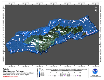
CRED Cumulative Fish Biomass map at Tutuila Island
National Oceanic and Atmospheric Administration, Department of Commerce —
This map displays fish biomass observation locations overlaid on bathymetry. -
Federal
CRED Cumulative Map of Percent Scleractinian Coral Cover at Tutuila
National Oceanic and Atmospheric Administration, Department of Commerce —
This map displays optical validation observation locations and percent coverage of scleractinian coral overlaid on bathymetry. -
Federal
CRED Map of Percent Hard Coral Cover at Tutuila Island, American Samoa
National Oceanic and Atmospheric Administration, Department of Commerce —
This map displays optical validation observation locations and percent coverage of hard coral overlaid on bathymetry. -
Federal
CRED Cumulative Map of Percent Scleractinian Coral Cover at Ta'u
National Oceanic and Atmospheric Administration, Department of Commerce —
This map displays optical validation observation locations and percent coverage of scleractinian coral overlaid on bathymetry.
5 datasets found