
-
Federal
Integrated Surface Dataset (Global) 152 recent views
National Oceanic and Atmospheric Administration, Department of Commerce —
The Integrated Surface Dataset (ISD) is composed of worldwide surface weather observations from over 35,000 stations, though the best spatial coverage is evident in... -
Federal
RapidScat Level 2B Climate Ocean Wind Vectors in 12.5km Footprints Version 2.0
National Aeronautics and Space Administration —
This dataset contains the RapidScat Level 2B 12.5km Version 2.0 Climate quality ocean surface wind vectors. The Level 2B wind vectors are binned on a 12.5 km Wind... -
State
Rockfish Conservation Area Waypoints - R7 - CDFW [ds3145]
State of California —
Rockfish Conservation Areas (RCAs) are closed areas for west coast groundfish fisheries and for some fisheries that may incidentally take groundfish as bycatch. The... -
Federal
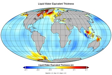
JPL GRACE and GRACE-FO Mascon Ocean, Ice, and Hydrology Equivalent Water Height Coastal Resolution Improvement (CRI) Filtered Release 06.1 Version 03
National Aeronautics and Space Administration —
This dataset contains gridded monthly global water storage/height anomalies relative to a time-mean, derived from GRACE and GRACE-FO and processed at JPL using the... -
Federal
CSR TELLUS GRACE-FO Level-3 Monthly Ocean Bottom Pressure Anomaly Release 6.1 version 04
National Aeronautics and Space Administration —
The monthly ocean bottom pressure anomaly grids are given as equivalent water thickness changes derived from GRACE & GRACE-FO time-variable gravity observations... -
Federal
GFZ TELLUS GRACE Level-3 Monthly Ocean Bottom Pressure Anomaly Release 6.0 version 04
National Aeronautics and Space Administration —
The monthly ocean bottom pressure anomaly grids are given as equivalent water thickness changes derived from GRACE & GRACE-FO time-variable gravity observations... -
State
DEEP Boat Launches
State of Connecticut —
Connecticut DEP Boat Lauch is a point feature-based layer that includes all DEP boat lauch locations in the State of Connecticut. Types of boat launce in this layer... -
Federal
Tellus Level-4 Ocean Mass Anomaly Time Series from JPL GRACE/GRACE-FO Mascon CRI Filtered Release 06.1 version 03
National Aeronautics and Space Administration —
This dataset is a time series of mass variability averaged over all of the global ocean. It provides the non-steric or mass only sea level changes over time. The mass... -
Federal
RapidScat Level 2B Ocean Wind Vectors in 12.5km Slice Composites Version 1.2
National Aeronautics and Space Administration —
This dataset contains the RapidScat Level 2B 12.5km Version 1.2 science-quality ocean surface wind vectors, which are intended as a replacement and continuation of... -
Federal
JPL TELLUS GRACE-FO Level-3 Monthly Ocean Bottom Pressure Anomaly Release 6.1 version 04
National Aeronautics and Space Administration —
The monthly ocean bottom pressure anomaly grids are given as equivalent water thickness changes derived from GRACE & GRACE-FO time-variable gravity observations... -
Federal
JPL TELLUS GRACE Level-3 Monthly Ocean Bottom Pressure Anomaly Release 6.0 version 04
National Aeronautics and Space Administration —
The monthly ocean bottom pressure anomaly grids are given as equivalent water thickness changes derived from GRACE & GRACE-FO time-variable gravity observations... -
Federal
JPL GRACE and GRACE-FO Mascon Ocean, Ice, and Hydrology Equivalent Water Height JPL Release 06.1 Version 03
National Aeronautics and Space Administration —
This dataset contains gridded monthly global water storage/height anomalies relative to a time-mean, derived from GRACE and GRACE-FO and processed at JPL using the... -
Federal
CSR TELLUS GRACE-FO Level-3 Monthly Ocean Bottom Pressure Anomaly Release 6.2 version 04
National Aeronautics and Space Administration —
This TELLUS_GRFO_L3_CSR_RL06.2_OCN_v04 dataset produced by the CSR GRACE-FO program derives the ocean bottom pressure (OBP) anomaly using the Gravity Recovery and... -
State
Continually Updated Shoreline Product
State of Oregon —
The Oregon CUSP shoreline represents a "best of" attempt to create a continuous Mean High Water Shoreline for use in GIS analysis and inventory work. Whenever... -
Federal
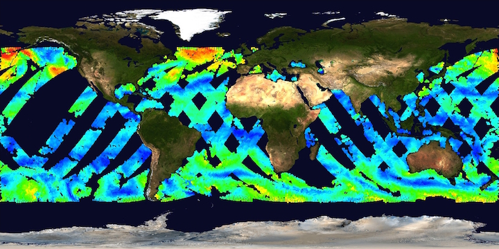
Remote Sensing Systems Radiometer Rain Collocations with JPL RapidScat L2B Swath Grid
National Aeronautics and Space Administration —
This dataset contains the multi-sourced microwave radiometer wind speed, rain and cloud liquid water data collocated to RapidScat Level 2B wind vector cell (WVC)... -
Federal
BLM OR Ocean Lines Hub
Department of the Interior —
OCEAN_ARC: This data set portrays the line representation of the Pacific Ocean's shoreline from the area of Vancouver Island to south of San Francisco Bay. -
Federal
Tellus Level-4 Greenland Mass Anomaly Time Series from JPL GRACE/GRACE-FO Mascon CRI Filtered Release 06.1 version 03
National Aeronautics and Space Administration —
This dataset is a time series of mass variability averaged over all of the global ocean. It provides the non-steric or mass only sea level changes over time. The mass... -
State
Environmental Sensitivity Index 2002 Lines
State of Connecticut —
Environmental Sensitivity Index 2002 Set: This data set contains vector lines representing the shoreline and coastal habitats of Connecticut classified according to... -
Federal
BLM OR Ocean Poly Hub
Department of the Interior —
OCEAN_POLY: This data set portrays the portion of the Pacific Ocean and its islands from near Vancouver Island to south of San Francisco Bay and far enough to the... -
Federal
Archival and Discovery of May 16, 1968 Tsunami Event on Marigrams
National Oceanic and Atmospheric Administration, Department of Commerce —
NOAA National Centers for Environmental Information have more than 3,000 tsunami marigram (tide gauge) records in both image and paper format. The majority of these...

Official websites use .gov
A
.gov website belongs to an official government
organization in the United States.
Secure .gov websites use HTTPS
A
lock (
) or https:// means you’ve safely connected to
the .gov website. Share sensitive information only on official,
secure websites.