
-
Federal
Global Landslide Hazard Distribution
National Aeronautics and Space Administration —
The Global Landslide Hazard Distribution is a 2.5 minute grid of global landslide and snow avalanche hazards based upon work of the Norwegian Geotechnical Institute... -
Federal
A Global Database of Gas Fluxes from Soils after Rewetting or Thawing, Version 1.0
National Aeronautics and Space Administration —
This database contains information compiled from published studies on gas flux from soil following rewetting or thawing. The resulting database includes 222 field and... -
Federal
CSR TELLUS GRACE-FO Level-3 Monthly Land Water-Equivalent-Thickness Surface Mass Anomaly Release 6.3 version 04
National Aeronautics and Space Administration —
This data set is produced by the Center for Space Research (CSR) GRACE-FO (Gravity Recovery and Climate Experiment Follow-On) program and derives the terrestrial... -
Federal
AVIRIS-NG L2 Surface Reflectance, Facility Instrument Collection, V1
National Aeronautics and Space Administration —
This dataset contains Level 2 (L2) orthocorrected reflectance from the Airborne Visible / Infrared Imaging Spectrometer-Next Generation (AVIRIS-NG) instrument. This... -
Federal
ABoVE: Thaw Depth at Selected Unburned and Burned Sites Across Alaska
National Aeronautics and Space Administration —
This dataset provides thaw depth measurements made at seven locations across Alaska, during August 2016, June and September 2017, and July-August 2018. Three of the... -
Federal
JPL TELLUS GRACE-FO Level-3 Monthly Land Water-Equivalent-Thickness Surface Mass Anomaly Release 6.3 version 04
National Aeronautics and Space Administration —
This data set is produced by the Jet Propulsion Laboratory (JPL) as part of the GRACE-FO (Gravity Recovery and Climate Experiment Follow-On) program and derives the... -
Federal
GHRSST Level 3U Global Subskin Sea Surface Temperature version 8a from the Advanced Microwave Scanning Radiometer 2 on the GCOM-W satellite
National Aeronautics and Space Administration —
GDS2 Version -The Advanced Microwave Scanning Radiometer 2 (AMSR2) was launched on 18 May 2012, onboard the Golbal Change Observation Mission - Water (GCOM-W)... -
Federal
Global Pesticide Grids (PEST-CHEMGRIDS), Version 1.01
National Aeronautics and Space Administration —
The Global Pesticide Grids (PEST-CHEMGRIDS), Version 1.01 data set contains 20 of the most-used pesticide active ingredients on 6 dominant crops and 4 aggregated crop... -
Federal
MiCASA Daily NPP Rh ATMC NEE FIRE FUEL Fluxes 0.1 degree x 0.1 degree
National Aeronautics and Space Administration —
MiCASA is an extensive revision of CASA-GFED3. CASA-GFED3 derives from Potter et al. (1993), diverging in development since Randerson et al. (1996). CASA is a light... -
Federal
ECOSTRESS Evapotranspiration PT-JPL Daily L3 Global 70m V001
National Aeronautics and Space Administration —
The ECOsystem Spaceborne Thermal Radiometer Experiment on Space Station (ECOSTRESS) mission measures the temperature of plants to better understand how much water... -
Federal
ABoVE: Boreal Forest Resilience Study 2020-2022, Fairbanks AK
National Aeronautics and Space Administration —
This dataset includes five metrics of forest resilience (recruitment, invasives, permafrost change, tree damage, and radial growth) at five recently burned forest... -
Federal
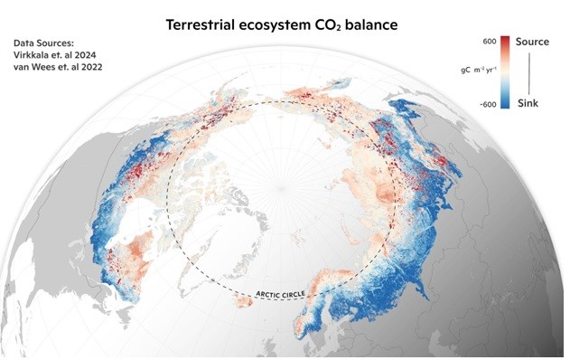
Machine learning-based Arctic-boreal terrestrial ecosystem CO2 fluxes, 2001-2020
National Aeronautics and Space Administration —
This dataset provides gridded estimates of gross primary productivity (GPP), ecosystem respiration (Reco), and net ecosystem CO2 exchange (NEE) across the circumpolar... -
Federal
Global Gridded Surfaces of Selected Soil Characteristics (IGBP-DIS)
National Aeronautics and Space Administration —
The Global Gridded Surfaces of Selected Soil Characteristics (IGBP-DIS) data set contains 7 data surfaces: soil-carbon density, total nitrogen density, field... -
Federal
GHRSST Level 3U Global Subskin Sea Surface Temperature version7.0.1a from the WindSat Polarimetric Radiometer on the Coriolis satellite
National Aeronautics and Space Administration —
The WindSat Polarimetric Radiometer, launched on January 6, 2003 aboard the Department of Defense Coriolis satellite, was designed to measure the ocean surface wind... -
Federal
The Bronson Files, Dataset 4, Field 105, 2013
Department of Agriculture —
Dr. Kevin Bronson provides this unique nitrogen and water management in wheat agricultural research dataset for compute. Ten irrigation treatments from a linear... -
Federal
Multi-Mission Optimally Interpolated Sea Surface Salinity Global Monthly Dataset V1
National Aeronautics and Space Administration —
This is a level 4 product on a 0.25-degree spatial and monthly temporal grid. The product is the monthly mean of the level 4 OISSS dataset using three satellite... -
Federal
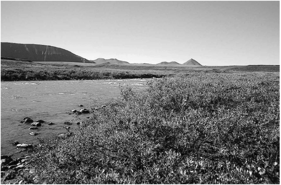
Arctic Vegetation Plots in Willow Communities, North Slope, Alaska, 1997
National Aeronautics and Space Administration —
This data set provides environmental, soil, and vegetation data collected in July and August 1997 from 85 study plots in willow shrub communities located along a... -
Federal
Probabilistic Freeze-Thaw Record for the Northern Hemisphere, 2016-2020
National Aeronautics and Space Administration —
This dataset provides a probabilistic freeze/thaw (FT) data record from 2016 to 2020 for the Northern Hemisphere derived using a deep learning model (U-Net). The... -
Federal
The Bronson Files, Dataset 2, Field 17, 2013
Department of Agriculture —
Dr. Kevin Bronson provides this unique nitrogen and water management in cotton agricultural research dataset for compute, including notation of field events and...

Official websites use .gov
A
.gov website belongs to an official government
organization in the United States.
Secure .gov websites use HTTPS
A
lock (
) or https:// means you’ve safely connected to
the .gov website. Share sensitive information only on official,
secure websites.