
-
Federal
Global Soil Types, 0.5-Degree Grid (Modified Zobler)
National Aeronautics and Space Administration —
A global data set of soil types is available at 0.5-degree latitude by 0.5-degree longitude resolution. There are 106 soil units, based on Zobler?s (1986) assessment... -
Federal
NACP Integrated Wildland and Cropland 30-m Fuel Characteristics Map, U.S.A., 2010
National Aeronautics and Space Administration —
The data set provides a 30-m comprehensive fuelbed characteristics map for both the wildland and cropland areas of the conterminous United States (CONUS) for 2010.... -
Federal
Daymet: Daily Surface Weather Data on a 1-km Grid for North America, Version 4 R1
National Aeronautics and Space Administration —
This dataset provides Daymet Version 4 R1 data as gridded estimates of daily weather parameters for North America, Hawaii, and Puerto Rico. Daymet variables include... -
Federal
Daily FluxSat GPP of biomass over Land, Based on MODIS Terra and Aqua adjusted reflectance Collection 6.1, on a Global 0.5 by 0.625 Degree Grid, Level 3 Version 2.2
National Aeronautics and Space Administration —
This dataset provides global gridded daily estimates of gross primary production (GPP) and uncertainties at 0.5 deg latitude by 0.625 deg longitude resolution for the... -
Federal
NOAA/WDS Paleoclimatology - Bigio fire data from Verkhiye Tal'tsy, Siberia - IMPD RUTAL001
National Oceanic and Atmospheric Administration, Department of Commerce —
This archived Paleoclimatology Study is available from the NOAA National Centers for Environmental Information (NCEI), under the World Data Service (WDS) for... -
Federal
NOAA/WDS Paleoclimatology - Brown fire data from Manitou Demo Plot - IMPD USMDP001
National Oceanic and Atmospheric Administration, Department of Commerce —
This archived Paleoclimatology Study is available from the NOAA National Centers for Environmental Information (NCEI), under the World Data Service (WDS) for... -
Federal
CERES Energy Balanced and Filled (EBAF) TOA and Surface Monthly means data in netCDF Edition 4.1
National Aeronautics and Space Administration —
CERES_EBAF_Edition4.1 is the Clouds and the Earth's Radiant Energy System (CERES) Energy Balanced and Filled (EBAF) Top-of-Atmosphere (TOA) and surface monthly means... -
Federal
NOAA/WDS Paleoclimatology - Hessl fire data from Bogd Mountain - IMPD MNBOG001
National Oceanic and Atmospheric Administration, Department of Commerce —
This archived Paleoclimatology Study is available from the NOAA National Centers for Environmental Information (NCEI), under the World Data Service (WDS) for... -
Federal
MODIS/Aqua Sea Ice Extent and IST Daily L3 Global 4km EASE-Grid Day V061 NGDA
National Aeronautics and Space Administration —
This global Level-3 (L3) data set provides Northern and Southern Hemisphere maps of sea ice extent and ice surface temperature. The maps are generated by compositing... -
Federal
ADVANCED MICROWAVE SOUNDING UNIT-A (AMSU-A) SWATH FROM NOAA-15 V1
National Aeronautics and Space Administration —
AMSU-A, the Advanced Microwave Sounding Unit, is a 15-channel passive microwave radiometer used to profile atmospheric temperature and moisture from the earth's... -
Federal
NOAA/WDS Paleoclimatology - Yocom fire data from El Diferencial, Sierra Madre Oriental, Nuevo León, Mexico - IMPD MXDI-001
National Oceanic and Atmospheric Administration, Department of Commerce —
This archived Paleoclimatology Study is available from the NOAA National Centers for Environmental Information (NCEI), under the World Data Service (WDS) for... -
Federal
SCR/Nimbus-4 Level 1 Calibrated Radiances V001 (SCRN4L1RAD) at GES DISC
National Aeronautics and Space Administration —
SCRN4L1RAD is the Nimbus-4 Selective Chopper Radiometer (SCR) Level 1 Calibrated Radiances data product. The calibrated radiances are measured at 6 channels from 2.3... -
Federal
NOAA/WDS Paleoclimatology - Donnegan fire data from BSA Shortcut - IMPD USBSA001
National Oceanic and Atmospheric Administration, Department of Commerce —
This archived Paleoclimatology Study is available from the NOAA National Centers for Environmental Information (NCEI), under the World Data Service (WDS) for... -
Federal
CERES Single Scanner Footprint (SSF) TOA/Surface Fluxes, Clouds and Aerosols Terra-FM2 Edition4A
National Aeronautics and Space Administration —
CER_SSF_Terra-FM2-MODIS_Edition4A is the Clouds and the Earth's Radiant Energy System (CERES) Single Scanner Footprint (SSF) Top-of-the-Atmosphere (TOA)/Surface... -
Federal
NOAA/WDS Paleoclimatology - Margolis fire data from Seven Springs Plot 2, northern New Mexico - IMPD USSS-002
National Oceanic and Atmospheric Administration, Department of Commerce —
This archived Paleoclimatology Study is available from the NOAA National Centers for Environmental Information (NCEI), under the World Data Service (WDS) for... -
Federal
AQUA MODIS High Resolution Level 3 daily aerosol data, 0.1x0.1 degree grid Version 001 (AER_DBDT_D10KM_L3_MODIS_AQUA) at GES DISC
National Aeronautics and Space Administration —
This High-Resolution (0.1 x 0.1 degree) Level 3 daily Aerosol Optical Depth (AOD) product is generated by combining two Moderate Resolution Imaging Spectroradiometer... -
Federal
NOAA/WDS Paleoclimatology - Olson fire data from Dugout Riparian, Blue Mountains, Oregon - IMPD USDUG001
National Oceanic and Atmospheric Administration, Department of Commerce —
This archived Paleoclimatology Study is available from the NOAA National Centers for Environmental Information (NCEI), under the World Data Service (WDS) for... -
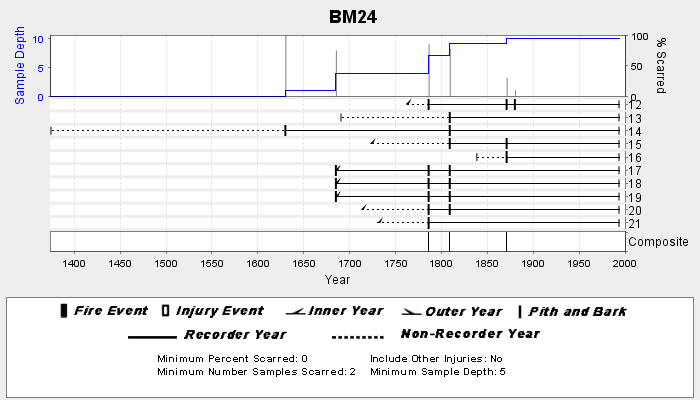
Federal
NOAA/WDS Paleoclimatology - Veblen fire data from BM24 - IMPD USBM-024
National Oceanic and Atmospheric Administration, Department of Commerce —
This archived Paleoclimatology Study is available from the NOAA National Centers for Environmental Information (NCEI), under the World Data Service (WDS) for... -
Federal
Global Vegetation Types, 1971-1982 (Matthews)
National Aeronautics and Space Administration —
The global vegetation type data of 1 x 1 degree latitude and longitude resolution were designed for use in studies of climate and climate change. Vegetation data were... -
Federal
MLS/Aura Level 3 Daily Binned Geopotential Height (GPH) on Zonal and Similar Grids V005 (ML3DZGPH) at GES DISC
National Aeronautics and Space Administration —
ML3DZGPH is the EOS Aura Microwave Limb Sounder (MLS) daily binned on zonal and assorted vertical grids product for geopotential height (GPH) derived from radiances...

Official websites use .gov
A
.gov website belongs to an official government
organization in the United States.
Secure .gov websites use HTTPS
A
lock (
) or https:// means you’ve safely connected to
the .gov website. Share sensitive information only on official,
secure websites.