
-
Federal
BOREAS Landsat TM Level-3s Imagery: Scaled At-Sensor Radiance in LGSOWG Format
National Aeronautics and Space Administration —
For BOREAS, the level-3s Landsat TM data, along with the other remotely sensed images, were collected in order to provide spatially extensive information over the... -
Federal
BOREAS Landsat TM Level-3a Imagery: Scaled At-Sensor Radiance in BSQ Format
National Aeronautics and Space Administration —
For BOREAS, the level-3A Landsat TM data, along with the other remotely sensed images, were collected in order to provide spatially extensive information over the... -
Federal
BOREAS TE-18 Landsat TM Maximum Likelihood Classification Image of the SSA
National Aeronautics and Space Administration —
A Landsat-5 TM image from 06-Aug-1990 was used to derive this classification, the objective of which is to provide BOREAS investigators with a data product that... -
Federal
BOREAS TGB-12 Soil Carbon and Flux Data of NSA-MSA in Raster Format
National Aeronautics and Space Administration —
This data set contains (1) estimates of soil carbon stocks by horizon based on soil survey data and analyses of data from individual soil profiles; (2) estimates of... -
Federal
RLC AVHRR-Derived Land Cover, Former Soviet Union, Far East, 1-km, 1990
National Aeronautics and Space Administration —
This data set is a 1-kilometer resolution land cover map for the land area of the Primor'ye and Southern Khabarovsk Regions, in the Russian Far East, based on 1990... -
Federal
BOREAS HYD-04 Areal Snow Course Survey Data
National Aeronautics and Space Administration —
Contains the areal snow survey data collected by HYD-04. The flight line numbers that are included correspond to the flight lines from HYD-06 measurements. -
Federal
BOREAS TE-20 Supplementary Site Information For NSA Tower Sites
National Aeronautics and Space Administration —
Data for use in developing and testing models of forest ecosystem dynamics. The data set describes the soils and landscape characteristics of the NSA-MSA and tower... -
Federal
BOREAS Regional Soils Data in Raster Format and AEAC Projection
National Aeronautics and Space Administration —
This data set was gridded by BORIS staff from a vector data set received from Canadian Soil Information System (CanSIS). Data were gridded into the Albers Equal-Area... -
Federal
BOREAS TGB-12 Soil Carbon Data: NSA
National Aeronautics and Space Administration —
Contains the soil carbon data collected by TGB-12 in the northern study area. -
Federal
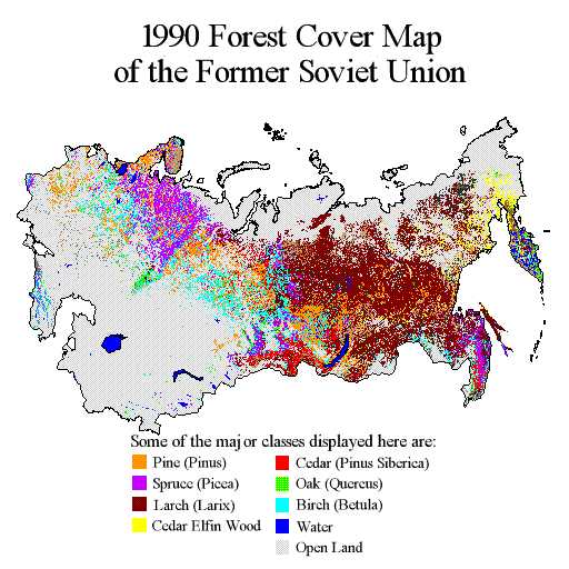
RLC Forest Cover Map of the Former Soviet Union, 1990
National Aeronautics and Space Administration —
This data set is a 1:2.5 million scale forest cover map for the land area of the Former Soviet Union that was completed in 1990 (Garsia 1990). There are forty-five... -
Federal
MISR Level 2 Surface parameters V002
National Aeronautics and Space Administration —
MIL2ASLS_2 is the Multi-angle Imaging SpectroRadiometer (MISR) Level 2 Land Surface parameters version 2 data product. It contains a variety of information on the... -
Federal
BOREAS AFM-12 1-km AVHRR Seasonal Land Cover Classification
National Aeronautics and Space Administration —
This regional land cover data set was developed as part of a multitemporal 1-km AVHRR land cover analysis approach that was used as the basis for regional land cover... -
Federal
BOREAS Landsat TM Level-3b Imagery: At-Sensor Radiance in BSQ Format
National Aeronautics and Space Administration —
For BOREAS, the level-3b Landsat TM data, along with the other remotely sensed images, were collected in order to provide spatially extensive information over the... -
Federal
BOREAS TE-18 Landsat TM Physical Classification Image of the NSA
National Aeronautics and Space Administration —
The objective of this classification is to provide BOREAS investigators with a data product that characterizes the land cover of the NSA. A Landsat-5 TM image from... -
Federal
BOREAS SERM Forest Cover Data Layers of the SSA in Vector Format
National Aeronautics and Space Administration —
This data set was prepared by the SERM-FBIU. The data include information on forest parameters and cover the area in and near the BOREAS SSA, excluding the PANP. -
Federal
BOREAS TE-18, 30-m, Radiometrically Rectified Landsat TM Imagery
National Aeronautics and Space Administration —
The BOREAS TE-18 team used a radiometric rectification process to produce standardized DN values for a series of Landsat TM images of the BOREAS SSA and NSA in order... -
Federal
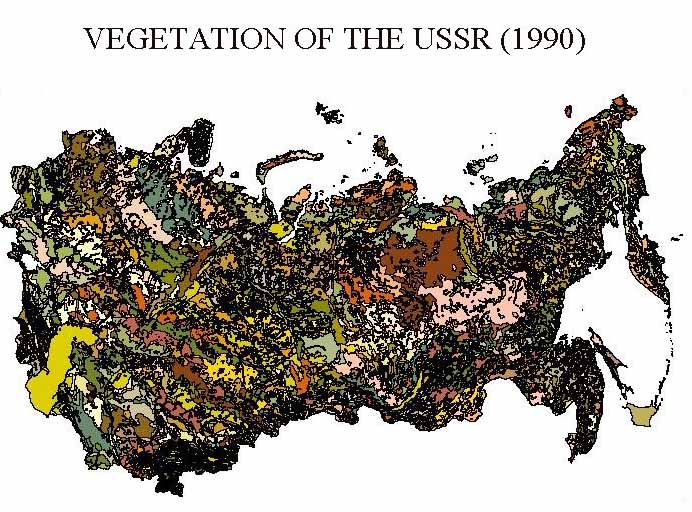
RLC Vegetative Cover of the Former Soviet Union, 1990
National Aeronautics and Space Administration —
This dataset is a 1:4 million scale vegetation map for the land area of the Former Soviet Union. Three hundred seventy-three cover classes are distinguished, of which... -
Federal
BOREAS Landsat TM Level-3p Imagery: Geocoded and Scaled At-Sensor Radiance
National Aeronautics and Space Administration —
For BOREAS, the level-3p Landsat TM data were used to supplement the level-3s Landsat TM products. Along with the other remotely sensed images, the Landsat TM images... -
Federal
BOREAS RSS-15 SIR-C and TM Biomass and Landcover Maps of the NSA and SSA
National Aeronautics and Space Administration —
The RSS-15 team conducted an investigation using SIR-C , X-SAR and Landsat TM data for estimating total above-ground dry biomass for the SSA and NSA modeling grids... -
Federal
BOREAS TE-18 Landsat TM Maximum Likelihood Classification Image of the NSA
National Aeronautics and Space Administration —
The objective of this classification is to provide the BOREAS investigators with a data product that characterizes the land cover of the NSA. A Landsat-5 TM image...

Official websites use .gov
A
.gov website belongs to an official government
organization in the United States.
Secure .gov websites use HTTPS
A
lock (
) or https:// means you’ve safely connected to
the .gov website. Share sensitive information only on official,
secure websites.