
-
Federal
CLPX-Ground: ISA Main Meteorological Data, Version 1
National Aeronautics and Space Administration —
This data set contains meteorological observations at ten sites throughout the Small Regional Study Area (SRSA) of the Cold Land Processes Field Experiment (CLPX) in... -
Federal
CERES Time-Interpolated TOA Fluxes, Clouds and Aerosols Daily NOAA-20 Edition1B
National Aeronautics and Space Administration —
The Clouds and the Earth's Radiant Energy System (CERES) Single Scanner Footprint One Degree (SSF1deg) Day provides daily averages of regional constant meteorology... -
Federal
TES/Aura L3 Deuterium Oxide Daily Gridded V006
National Aeronautics and Space Administration —
TL3HDOD_6 is the Tropospheric Emission Spectrometer (TES)/Aura Level 3 (L3) 3 Deuterium Oxide Daily Gridded Version 6 data product. It consists of daily atmospheric... -
Federal
NARSTO SOS99 Nashville WP-3D Orion Air Chemistry Data
National Aeronautics and Space Administration —
NARSTO_SOS99NASH_WP3D_CHEMISTRY_DATA is the North American Research Strategy for Tropospheric Ozone (NARSTO) SOS99 Nashville WP-3D Orion Air Chemistry Data product.... -
Federal
TES/Aura L2 Ancillary Special Observation Product V007
National Aeronautics and Space Administration —
TL2ANCS_7 is the Tropospheric Emission Spectrometer (TES)/Aura Level 2 Ancillary Special Observation Product Version 7 data product. TES was an instrument aboard... -
Federal
CAMEX-4 AEROSONDE V1
National Aeronautics and Space Administration —
The CAMEX-4 Aerosonde dataset contains temperature, humidity, and atmospheric pressure measurements collected to study the boundary layer below levels where... -
Federal
FLDAS Noah Land Surface Model L4 Global Monthly 0.1 x 0.1 degree (GDAS and CHIRPS-PRELIM) V001 (FLDAS_NOAH01_CP_GL_M) at GES DISC
National Aeronautics and Space Administration —
This dataset contains a series of land surface parameters simulated from the Noah 3.6.1 model in the Famine Early Warning Systems Network (FEWS NET) Land Data... -
Federal
Sounder SIPS: Suomi NPP ATMS Level 3 RAMSES2 Standard Gridded Daily V3 at GES DISC
National Aeronautics and Space Administration —
This level 3 daily product is generated from the RAMSES (Retrieval Algorithm for Microwave Sounders in Earth Science) II algorithm.The RAMSES II algorithm is a... -
Federal
Aqua/AIRS L3 Monthly Standard Physical Retrieval (AIRS+AMSU) 1 degree x 1 degree V7.0 at GES DISC
National Aeronautics and Space Administration —
The Atmospheric Infrared Sounder (AIRS) is a grating spectrometer (R = 1200) aboard the second Earth Observing System (EOS) polar-orbiting platform, EOS Aqua. In... -
Federal
First ISCCP Regional Experiment (FIRE) Atlantic Stratocumulus Transition Experiment (ASTEX) Rawinsonde Level 2 Data
National Aeronautics and Space Administration —
The First ISCCP Regional Experiments have been designed to improve data products and cloud/radiation parameterizations used in general circulation models (GCMs).... -
Federal
SAGE III/ISS L2 Monthly Solar Event Species Profiles (NetCDF) V052
National Aeronautics and Space Administration —
g3bsmnc_52 is the Stratospheric Aerosol and Gas Experiment III (SAGE III) on the International Space Station (ISS) (SAGE III/ISS) Level 2 Monthly Solar Event Species... -
Federal
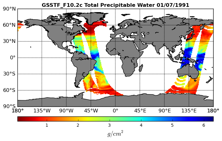
Goddard Satellite-Based Surface Turbulent Fluxes, 0.25 x 0.25 deg, Daily Grid F10 V3 (GSSTF_F10) at GES DISC
National Aeronautics and Space Administration —
These data are part of the Goddard Satellite-based Surface Turbulent Fluxes Version 3 (GSSTF3) Dataset recently produced through a MEaSURES funded project led by Dr.... -
Federal
Sounder SIPS: Suomi NPP CrIMSS Level 3 Specific Quality Control Gridded Monthly CHART Normal Spectral Resolution V1
National Aeronautics and Space Administration —
The objective of this limited edition data collection is to examine products generated by the Climate Heritage AIRS Retrieval Technique (CHART) algorithm to analyze... -
Federal
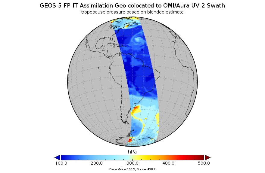
GEOS-5 FP-IT Assimilation Geo-colocated to OMI/Aura UV-2 1-Orbit L2 Support Swath 13x24km V3 (OMUFPITMET) at GES DISC
National Aeronautics and Space Administration —
The GEOS-5 FP-IT Assimilation Geo-colocated to OMI/Aura UV-2 1-Orbit L2 Support Swath 13x24km (OMUFPITMET) provides selected parameters from GEOS-5 Forward Processing... -
Federal
ACTIVATE King Air Meteorological and Navigational Data
National Aeronautics and Space Administration —
ACTIVATE_MetNav_AircraftInSitu_KingAir_Data is the meteorological and navigational data collected onboard the B-200 King Air aircraft via in-situ instrumentation... -
Federal
KORUS-AQ B200 Aircraft In Situ Meteorological and Navigational Data
National Aeronautics and Space Administration —
KORUSAQ_MetNav_AircraftInSitu_B200_Data are in-situ meteorological and navigational data collected onboard the B200 aircraft during the KORUS-AQ field campaign. This... -
Federal
GEOS-5 FP-IT 3D Time-Averaged Model-Layer Assimilated Data Geo-Colocated to OMI/Aura VIS 1-Orbit L2 Swath 13x24km V4 (OMVFPMET) at GES DISC
National Aeronautics and Space Administration —
The GEOS-5 FP-IT 3D Time-Averaged Model-Layer Assimilated Data Geo-Colocated to OMI/Aura VIS 1-Orbit L2 Swath 13x24km (OMVFPMET) product provides selected... -
Federal
GPM GROUND VALIDATION UND CITATION NAVIGATION DATA IPHEx V1
National Aeronautics and Space Administration —
The GPM Ground Validation UND Citation Navigation Data IPHEx dataset supplies navigation data collected by the Cessna Citation II aircraft for flights that occurred... -
Federal
GEWEX SRB Integrated Product (Rel-4) Ancillary 3-Hourly Ocean-only
National Aeronautics and Space Administration —
GEWEXSRB_Rel4-IP_Ancillary_3hrly_oceanonly is the Global Energy and Water Exchanges (GEWEX) Surface Radiation Budget (SRB) Integrated Product (Rel-4) Ancillary... -
Federal
DISCOVER-AQ Colorado Deployment Table Mountain Ground Site Data
National Aeronautics and Space Administration —
DISCOVERAQ_Colorado_Ground_TableMountain_Data contains data collected at the Table Mountain ground site during the Colorado (Denver) deployment of NASA's DISCOVER-AQ...

Official websites use .gov
A
.gov website belongs to an official government
organization in the United States.
Secure .gov websites use HTTPS
A
lock (
) or https:// means you’ve safely connected to
the .gov website. Share sensitive information only on official,
secure websites.