
-
Federal
NOAA/WDS Paleoclimatology - CLIMAP 18K Database
National Oceanic and Atmospheric Administration, Department of Commerce —
This archived Paleoclimatology Study is available from the NOAA National Centers for Environmental Information (NCEI), under the World Data Service (WDS) for... -
Federal
NOAA/WDS Paleoclimatology - Power et al. 2008 Global Charcoal Database
National Oceanic and Atmospheric Administration, Department of Commerce —
This archived Paleoclimatology Study is available from the NOAA National Centers for Environmental Information (NCEI), under the World Data Service (WDS) for... -
Federal
H13734: NOS Hydrographic Survey , 2023-08-17
National Oceanic and Atmospheric Administration, Department of Commerce —
The National Oceanic and Atmospheric Administration (NOAA) has the statutory mandate to collect hydrographic data in support of nautical chart compilation for safe... -
Federal
F01 Accelerometer - Waves
National Oceanic and Atmospheric Administration, Department of Commerce —
Ocean observation data from the Northeastern Regional Association of Coastal & Ocean Observing Systems (NERACOOS). The NERACOOS region includes the northeast... -
Federal
Annual California Sea Otter Census: 2019 Census Summary Shapefile
Department of the Interior —
The GIS shapefile Census_sum_2019 provides a standardized tool for examining spatial patterns in abundance and demographic trends of the southern sea otter (Enhydra... -
Federal
RESTORE Sponsored Research Project: Protecting Texas coastlines from potential oil spills in Galveston Bay using drone surveys and maps of a new response effectiveness index
National Oceanic and Atmospheric Administration, Department of Commerce —
Galveston Bay and the surrounding Texas coast are vulnerable to marine oil spills, from both the high volume of marine commerce through the Galveston Bay ship channel... -
Federal
Flood Hazard Zones - Guam
National Oceanic and Atmospheric Administration, Department of Commerce —
FEMA Flood Hazard Zones for Guam. -
Federal
Kawaihae, Hawaii 1/3 arc-second MHW Coastal Digital Elevation Model
National Oceanic and Atmospheric Administration, Department of Commerce —
NOAA's National Geophysical Data Center (NGDC) is building high-resolution digital elevation models (DEMs) for select U.S. coastal regions. These integrated... -
Federal
F00909: NOS Hydrographic Survey , 2024-09-30
National Oceanic and Atmospheric Administration, Department of Commerce —
The National Oceanic and Atmospheric Administration (NOAA) has the statutory mandate to collect hydrographic data in support of nautical chart compilation for safe... -
Federal
NOAA/WDS Paleoclimatology - Tongue of the Ocean - Sclerosponge Stable Isotope Data
National Oceanic and Atmospheric Administration, Department of Commerce —
This archived Paleoclimatology Study is available from the NOAA National Centers for Environmental Information (NCEI), under the World Data Service (WDS) for... -
Federal
Hydrographic and Impairment Statistics Database: KLGO
Department of the Interior —
Hydrographic and Impairment Statistics (HIS) is a National Park Service (NPS) Water Resources Division (WRD) project established to track certain goals created in... -
Federal
F00919: NOS Hydrographic Survey , 2025-06-03
National Oceanic and Atmospheric Administration, Department of Commerce —
The National Oceanic and Atmospheric Administration (NOAA) has the statutory mandate to collect hydrographic data in support of nautical chart compilation for safe... -
Federal
NCDC International Best Track Archive for Climate Stewardship (IBTrACS) Project, Version 3
National Oceanic and Atmospheric Administration, Department of Commerce —
The International Best Track Archive for Climate Stewardship (IBTrACS) dataset was developed by the NOAA National Climatic Data Center, which took the initial step of... -
Federal
Near-Real Time Surface Ocean Velocity, Hawaii, 6 km Resolution
National Oceanic and Atmospheric Administration, Department of Commerce —
Surface ocean velocities estimated from HF-Radar (HFR) are representative of the upper 0.3 - 2.5 meters of the ocean. The main objective of near-real time processing... -
Federal
H12572: NOS Hydrographic Survey , Delaware Bay and Approaches, 2013-09-16
National Oceanic and Atmospheric Administration, Department of Commerce —
The National Oceanic and Atmospheric Administration (NOAA) has the statutory mandate to collect hydrographic data in support of nautical chart compilation for safe... -
Federal
F00646: NOS Hydrographic Survey , 2014-10-22
National Oceanic and Atmospheric Administration, Department of Commerce —
The National Oceanic and Atmospheric Administration (NOAA) has the statutory mandate to collect hydrographic data in support of nautical chart compilation for safe... -
Federal
I01 Optics
National Oceanic and Atmospheric Administration, Department of Commerce —
Ocean observation data from the Northeastern Regional Association of Coastal & Ocean Observing Systems (NERACOOS). The NERACOOS region includes the northeast... -
Federal
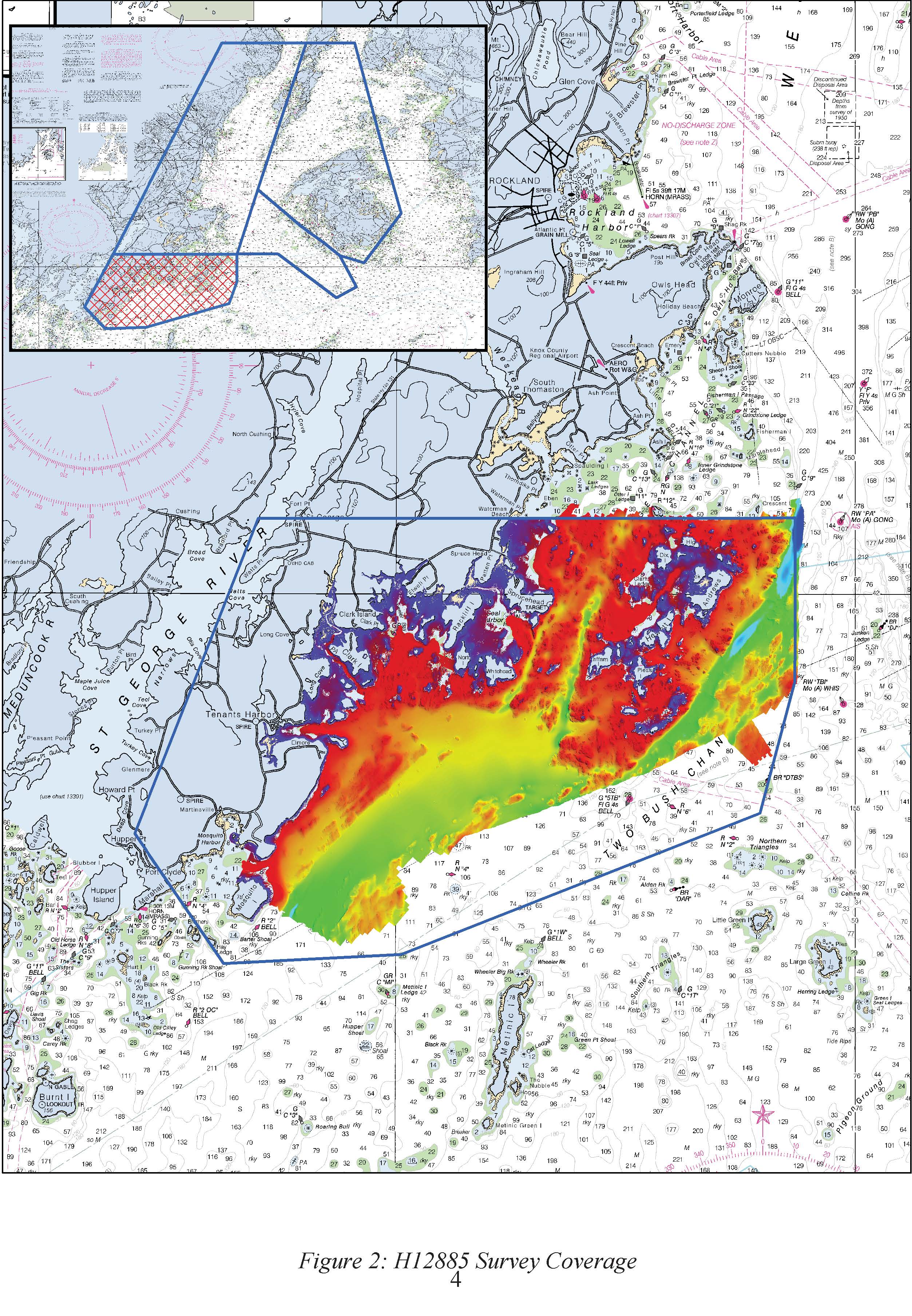
H12885: NOS Hydrographic Survey , 2016-09-29
National Oceanic and Atmospheric Administration, Department of Commerce —
The National Oceanic and Atmospheric Administration (NOAA) has the statutory mandate to collect hydrographic data in support of nautical chart compilation for safe... -
Federal
H13449: NOS Hydrographic Survey , 2021-07-21
National Oceanic and Atmospheric Administration, Department of Commerce —
The National Oceanic and Atmospheric Administration (NOAA) has the statutory mandate to collect hydrographic data in support of nautical chart compilation for safe... -
Federal
Diffuse Attenuation Coef. K490, Aqua MODIS, NPP, 0.0125°, West US, 2002-present (1 Day Composite)
National Oceanic and Atmospheric Administration, Department of Commerce —
NASA distributes Diffuse Attenuation Coefficient at 490 nm Wavelength data from NASA's Aqua satellite. Measurements are gathered by the Moderate Resolution Imaging...

Official websites use .gov
A
.gov website belongs to an official government
organization in the United States.
Secure .gov websites use HTTPS
A
lock (
) or https:// means you’ve safely connected to
the .gov website. Share sensitive information only on official,
secure websites.