
-
Federal
Nenana Ice Classic: Tanana River Ice Annual Breakup Dates, Version 2
National Aeronautics and Space Administration —
The Tanana river in the Interior of Alaska usually freezes over during October and November. The ice continues to grow throughout the winter accumulating an average... -
Federal
NLDAS Primary Forcing Data L4 Monthly 0.125 x 0.125 degree V2.0 (NLDAS_FORA0125_M) at GES DISC
National Aeronautics and Space Administration —
This data product contains the monthly primary forcing data "File A" for Phase 2 of the North American Land Data Assimilation System (NLDAS-2). The data are in 1/8th... -
Federal
NACP North American Forest Dynamics Project: Forest Disturbance and Regrowth Data
National Aeronautics and Space Administration —
This data set provides the results of time-series analyses of Landsat imagery for 55 selected forested sites across the conterminous U.S.A. The output is a pair of... -
Federal
Lunar Laser Ranging (LLR) data from NASA CDDIS
National Aeronautics and Space Administration —
Lunar Laser Ranging (LLR) measures the distance between the Earth and the Moon using laser ranging. A short pulse of coherent light generated by a laser (Light... -
Federal
ASTER Global Digital Elevation Model V003
National Aeronautics and Space Administration —
The Terra Advanced Spaceborne Thermal Emission and Reflection Radiometer (ASTER) Global Digital Elevation Model (GDEM) Version 3 (ASTGTM) provides a global digital... -
Federal
Glacier Photograph Collection, Version 1
National Aeronautics and Space Administration —
Notice: Due to funding limitations, this data set was recently changed to a “Basic” Level of Service. Learn more about what this means for users and how you can share... -
Federal
Sea Ice Index, Version 4
National Aeronautics and Space Administration —
Notice: Due to funding limitations, this data set was recently changed to a “Basic” Level of Service. Learn more about what this means for users and how you can share... -
Federal
TSIS TIM Level 3 Total Solar Irradiance 24-Hour Means V04 (TSIS_TSI_L3_24HR) at GES DISC
National Aeronautics and Space Administration —
Version 04 is the current release of this data product, and supercedes all previous versions. The TSIS TIM Level 3 Total Solar Irradiance (TSI) 24-Hour Means data... -
Federal
QuickBird Level 1B Panchromatic Satellite Imagery
National Aeronautics and Space Administration —
The QuickBird Panchromatic Imagery collection contains satellite imagery acquired from Maxar Technologies by the Commercial Smallsat Data Acquisition (CSDA) Program.... -
Federal
MODIS/Terra Land Surface Temperature/Emissivity Daily L3 Global 1km SIN Grid V006
National Aeronautics and Space Administration —
The MOD11A1 Version 6 data product was decommissioned on July 31, 2023. Users are encouraged to use the MOD11A1... -
Federal
Daymet: Daily Surface Weather Data on a 1-km Grid for North America, Version 4 R1
National Aeronautics and Space Administration —
This dataset provides Daymet Version 4 R1 data as gridded estimates of daily weather parameters for North America, Hawaii, and Puerto Rico. Daymet variables include... -
Federal
MODIS/Terra+Aqua Land Cover Type Yearly L3 Global 500m SIN Grid V061
National Aeronautics and Space Administration —
The Terra and Aqua combined Moderate Resolution Imaging Spectroradiometer (MODIS) Land Cover Type (MCD12Q1) Version 6.1 data product provides global land cover types... -
Federal
Tara Oceans Pacific Expedition
National Aeronautics and Space Administration —
Data measured during the Tara Oceans Pacific Expedition, 2016-2018 -
Federal
GPM Ground Validation Daily Precipitation OLYMPEX
National Aeronautics and Space Administration —
The GPM Ground Validation Daily Precipitation Olympic Mountain Experiment (OLYMPEX) dataset consists of a single netCDF-4 data file containing estimates of daily... -
Federal
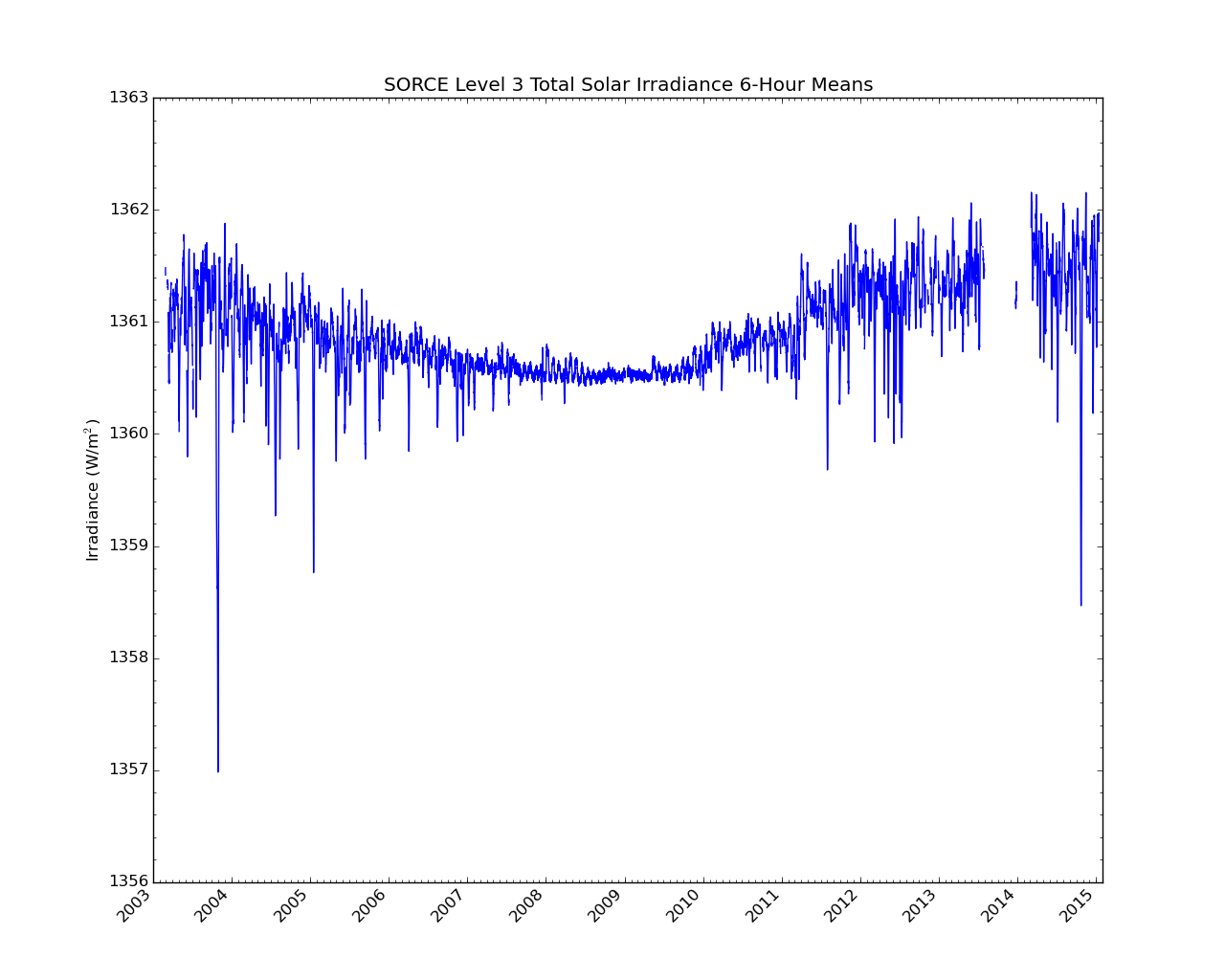
SORCE Level 3 Total Solar Irradiance 6-Hour Means V019 (SOR3TSI6) at GES DISC
National Aeronautics and Space Administration —
SOR3TSI6 Version 019 is the final version of this data product, and supersedes all previous versions. The Total Solar Irradiance (TSI) data set SOR3TSI6 contains the... -
Federal
A Compilation of Global Soil Microbial Biomass Carbon, Nitrogen, and Phosphorus Data
National Aeronautics and Space Administration —
This data set provides the concentrations of soil microbial biomass carbon (C), nitrogen (N) and phosphorus (P), soil organic carbon, total nitrogen, and total... -
Federal
Monthly gridded Global Land Data Assimilation System (GLDAS) from Noah-v3.3 land hydrology model for GRACE and GRACE-FO over nominal months
National Aeronautics and Space Administration —
The total land water storage anomalies are aggregated from the Global Land Data Assimilation System (GLDAS) NOAH model. GLDAS outputs land water content by using... -
Federal
NRT AMSR2 Unified L3 Daily 12.5 km Brightness Temperature & Sea Ice Concentration V4
National Aeronautics and Space Administration —
The Advanced Microwave Scanning Radiometer 2 (AMSR2) instrument on the Global Change Observation Mission - Water 1 (GCOM-W1) provides global passive microwave... -
Federal
Global Maps of Atmospheric Nitrogen Deposition, 1860, 1993, and 2050
National Aeronautics and Space Administration —
This data set provides global gridded estimates of atmospheric deposition of total inorganic nitrogen (N), NHx (NH3 and NH4+), and NOy (all oxidized forms of nitrogen...

Official websites use .gov
A
.gov website belongs to an official government
organization in the United States.
Secure .gov websites use HTTPS
A
lock (
) or https:// means you’ve safely connected to
the .gov website. Share sensitive information only on official,
secure websites.