
-
Federal
ASTER Global Digital Elevation Model V002
National Aeronautics and Space Administration —
The ASTGTM.002 dataset was decommissioned as of August 5, 2019. Users are encouraged to use the new improvedFederalGround-Based Global Navigation Satellite System (GNSS)-based Upper Atmospheric Realtime Disaster Information and Alert Network (GUARDIAN) Galileo daily antenna phase centers (24-hour files) from NASA CDDIS
National Aeronautics and Space Administration —
This product contains antenna phase center locations relative to the Galileo satellite's center of mass. The product is generated at JPL's Global Differential GPS...FederalIMS Daily Northern Hemisphere Snow and Ice Analysis at 1 km, 4 km, and 24 km Resolutions, Version 1
National Aeronautics and Space Administration —
This data set provides maps of snow cover and sea ice for the Northern Hemisphere from February 1997 to the present from the United States National Ice Center...FederalGround-Based GNSS-based Upper Atmospheric Realtime Disaster Information and Alert Network (GUARDIAN) GLONASS daily accumulated real-time Precise Orbit Determination (POD) Clock Corrections (60-second sampling, 24-hour files) from NASA CDDIS
National Aeronautics and Space Administration —
This product contains a high-rate time series of clock biases for healthy satellites in the GLONASS constellation that are accumulated every minute throughout the...FederalGround-Based GNSS-based Upper Atmospheric Realtime Disaster Information and Alert Network (GUARDIAN) GPS daily accumulated real-time Precise Orbit Determination (POD) orbits (60-second sampling, 24-hour files) from NASA CDDIS
National Aeronautics and Space Administration —
This product contains a time series of position and velocity components for healthy satellites in the GPS constellation that are accumulated every minute throughout...FederalGround-Based GNSS-based Upper Atmospheric Realtime Disaster Information and Alert Network (GUARDIAN) Galileo daily accumulated real-time Precise Orbit Determination (POD) Attitude Quaternions (30-second sampling, 24-hour files) from NASA CDDIS
National Aeronautics and Space Administration —
This product contains a time series of attitude quaternion components for healthy satellites in the Galileo constellation that are accumulated every minute throughout...FederalGround-Based Global Navigation Satellite System (GNSS)-based Upper Atmospheric Realtime Disaster Information and Alert Network (GUARDIAN) GLONASS daily antenna phase maps (meta data, 24-hour files) from NASA CDDIS
National Aeronautics and Space Administration —
This product contains file names and URLs to files containing antenna phase map data used in the real-time GLONASS POD processing. In particular, the IGS ANTEX file...FederalGround-Based Global Navigation Satellite System (GNSS)-based Upper Atmospheric Realtime Disaster Information and Alert Network (GUARDIAN) GLONASS Earth Orientation Parameters (1-day sampling, 7-day files) from NASA CDDIS
National Aeronautics and Space Administration —
This product contains a time series of Earth orientation parameters from the IERS Bulletin A for the GLONASS constellation of satellites. The product is generated at...FederalGround-Based Global Navigation Satellite System (GNSS)-based Upper Atmospheric Realtime Disaster Information and Alert Network (GUARDIAN) GPS Earth Orientation Parameters (1-day sampling, 7-day files) from NASA CDDIS
National Aeronautics and Space Administration —
This product contains a time series of Earth orientation parameters from the IERS Bulletin A for the GPS constellation of satellites. The product is generated at...FederalGround-Based Global Navigation Satellite System (GNSS)-based Upper Atmospheric Realtime Disaster Information and Alert Network (GUARDIAN) GLONASS daily antenna phase centers (24-hour files) from NASA CDDIS
National Aeronautics and Space Administration —
This product contains antenna phase center locations relative to the GLONASS satellite's center of mass. The product is generated at JPL's Global Differential GPS...FederalGround-Based Global Navigation Satellite System (GNSS)-based Upper Atmospheric Realtime Disaster Information and Alert Network (GUARDIAN) GPS daily antenna phase centers (24-hour files) from NASA CDDIS
National Aeronautics and Space Administration —
This product ontains antenna phase center locations relative to the GPS satellite's center of mass. The product is generated at JPL's Global Differential GPS...FederalGround-Based GNSS-based Upper Atmospheric Realtime Disaster Information and Alert Network (GUARDIAN) GLONASS daily accumulated real-time Precise Orbit Determination (POD) Clock Corrections (1-second sampling, 24-hour files) from NASA CDDIS
National Aeronautics and Space Administration —
This product contains a high-rate time series of clock biases for healthy satellites in the GLONASS constellation that are accumulated every minute throughout the...FederalGround-Based GNSS-based Upper Atmospheric Realtime Disaster Information and Alert Network (GUARDIAN) GLONASS daily accumulated real-time Precise Orbit Determination (POD) Attitude Quaternions (30-second sampling, 24-hour files) from NASA CDDIS
National Aeronautics and Space Administration —
This product contains a time series of attitude quaternion components for healthy satellites in the GLONASS constellation that are accumulated every minute throughout...FederalGround-Based GNSS-based Upper Atmospheric Realtime Disaster Information and Alert Network (GUARDIAN) GPS daily accumulated real-time Precise Orbit Determination (POD) Clock Corrections (1-second sampling, 24-hour files) from NASA CDDIS
National Aeronautics and Space Administration —
This product contains a high-rate time series of clock biases for healthy satellites in the GPS constellation that are accumulated every minute throughout the day. In...FederalGround-Based GNSS-based Upper Atmospheric Realtime Disaster Information and Alert Network (GUARDIAN) Galileo daily accumulated real-time Precise Orbit Determination (POD) Clock Corrections (1-second sampling, 24-hour files) from NASA CDDIS
National Aeronautics and Space Administration —
This product contains a time series of clock biases for healthy satellites in the Galileo constellation that are accumulated every minute throughout the day. In...FederalGround-Based GNSS-based Upper Atmospheric Realtime Disaster Information and Alert Network (GUARDIAN) Galileo daily accumulated real-time Precise Orbit Determination (POD) orbits (60-second sampling, 24-hour files) from NASA CDDIS
National Aeronautics and Space Administration —
This product contains a time series of position and velocity components for healthy satellites in the Galileo constellation that are accumulated every minute...FederalGround-Based GNSS-based Upper Atmospheric Realtime Disaster Information and Alert Network (GUARDIAN) GPS daily accumulated real-time Precise Orbit Determination (POD) Attitude Quaternions (30-second sampling, 24-hour files) from NASA CDDIS
National Aeronautics and Space Administration —
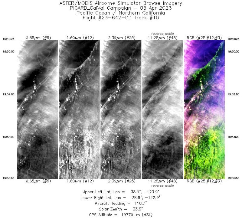
This product contains a time series of attitude quaternion components for healthy satellites in the GPS constellation that are accumulated every minute throughout the...FederalMASTER: Western Diversity Time Series Campaign, WDTS, Spring 2023
National Aeronautics and Space Administration —
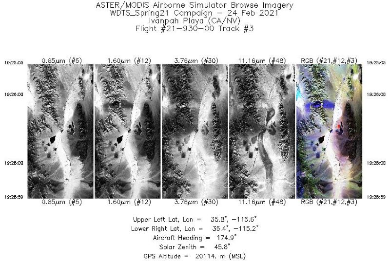
This dataset includes Level 1B (L1B) and Level 2 (L2) data products from the MODIS/ASTER Airborne Simulator (MASTER) instrument. The spectral data were collected as...FederalMASTER: Western Diversity Time Series Campaign, WDTS, California, USA, Spring 2021
National Aeronautics and Space Administration —
This dataset includes Level 1B (L1B) and Level 2 (L2) data products from the MODIS/ASTER Airborne Simulator (MASTER) instrument. The spectral data were collected as...FederalMASTER: Western Diversity Time Series Campaign, WDTS, September 2022
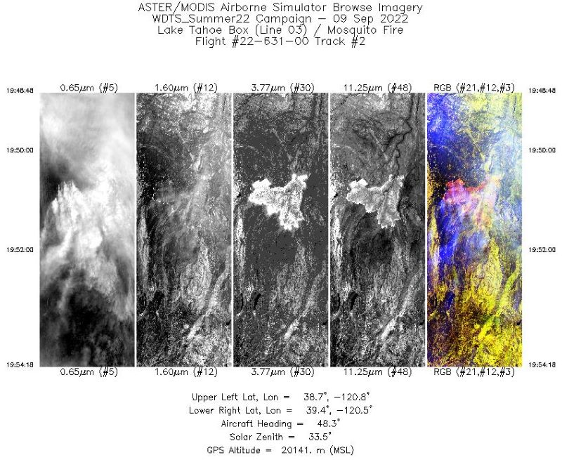
National Aeronautics and Space Administration —
This dataset includes Level 1B (L1B) and Level 2 (L2) data products from the MODIS/ASTER Airborne Simulator (MASTER) instrument. The spectral data were collected as...31 datasets found for "disaster"

Official websites use .gov
A
.gov website belongs to an official government
organization in the United States.
Secure .gov websites use HTTPS
A
lock (
) or https:// means you’ve safely connected to
the .gov website. Share sensitive information only on official,
secure websites.