
-
Federal
Arctic Vegetation Plots for IBP Tundra Biome, Barrow, Alaska, 1972-2010
National Aeronautics and Space Administration —
This data set provides vegetation cover and environmental plot data collected as part of the International Biological Program (IBP), U. S. Tundra Biome Program, in... -
Federal
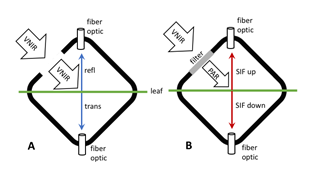
Tundra Plant Leaf-level Spectral Reflectance and Chlorophyll Fluorescence, 2019-2021
National Aeronautics and Space Administration —
This dataset provides leaf-level visible-near infrared spectral reflectance, chlorophyll fluorescence spectra, species, plant functional type (PFT), and chlorophyll... -
Federal
NACP Site: Terrestrial Biosphere Model and Aggregated Flux Data in Standard Format
National Aeronautics and Space Administration —
This data set provides standardized output variables for gross primary productivity (GPP), net ecosystem exchange (NEE), leaf area index (LAI), ecosystem respiration... -
Federal
CAR ARMCAS Arctic Cloud Radiation Measurements L1 V1 (CAR_ARMCAS_L1C) at GES DISC
National Aeronautics and Space Administration —
The Arctic Radiation Measurement in Column Atmosphere-surface System (ARMCAS) was a collaborative research effort between the Cloud and Aerosol Research (CAR) Group,... -
Federal
ABoVE: Thaw Depth at Selected Unburned and Burned Sites Across Alaska
National Aeronautics and Space Administration —
This dataset provides thaw depth measurements made at seven locations across Alaska, during August 2016, June and September 2017, and July-August 2018. Three of the... -
State
Tundra Swan Range - CWHR B067 [ds1411]
State of California —
Vector datasets of CWHR range maps are one component of California Wildlife Habitat Relationships (CWHR), a comprehensive information system and predictive model for... -
Federal
Tribal Colleges and Universities Directory
Department of the Interior —
Tribal Colleges and Universities (TCUs) are chartered by their respective tribal governments, including the ten tribes within the largest reservations in the United... -
Federal
Tribal Colleges and Universities (TCU)
Department of the Interior —
Tribal Colleges and Universities (TCUs) are chartered by their respective tribal governments, including the ten tribes within the largest reservations in the United... -
Federal
ABoVE: Soil Moisture and ALT Field Collection Protocols and Probe Calibration
National Aeronautics and Space Administration —
This dataset contains soil moisture sampling protocols and calibration algorithms for Campbell Scientific Hydrosense-I and II units used at burned and unburned sites... -
Federal
NACP Site: Terrestrial Biosphere Model Output Data in Original Format
National Aeronautics and Space Administration —
This data set contains the original model output data submissions from the 24 terrestrial biosphere models (TBM) that participated in the North American Carbon... -
Federal
NOAA's Coastal Change Analysis Program (C-CAP) land cover change data for the Continental and Coastal United States and Hawaii from 1975 to 2021 (NCEI Accession 0121254)
National Oceanic and Atmospheric Administration, Department of Commerce —
The NOAA Coastal Change Analysis Program (C-CAP) produces national standardized land cover and change products for the coastal regions of the U.S. C-CAP products... -
Federal
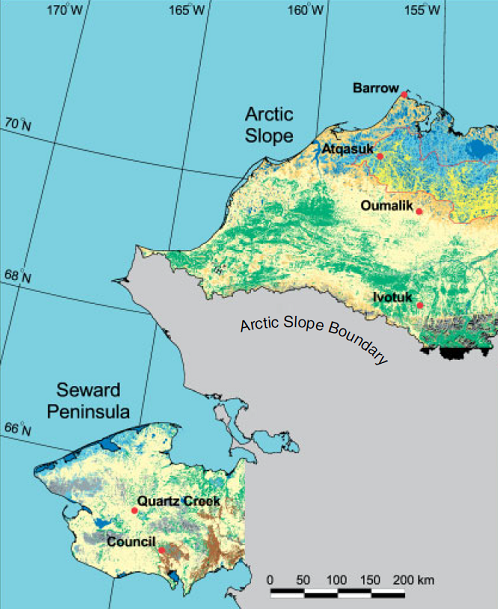
Arctic Vegetation Plots ATLAS Project North Slope and Seward Peninsula, AK, 1998-2000
National Aeronautics and Space Administration —
This data set provides environmental, soil, and vegetation data collected from study sites on the North Slope and Seward Peninsula of Alaska during the Arctic... -
Federal
ABoVE: Active Layer and Soil Moisture Properties from AirMOSS P-band SAR in Alaska
National Aeronautics and Space Administration —
This dataset provides estimates of soil geophysical properties derived from Airborne Microwave Observatory of Subcanopy and Subsurface (AirMOSS) P-band polarimetric... -
Federal
Global Seasonal-Snow Classification, Version 1
National Aeronautics and Space Administration —
This data set consists of global, seasonal snow classifications—e.g., tundra, boreal forest, maritime, ephemeral, prairie, montane forest, and ice—determined from air... -
Federal
Arctic Boreal Annual Burned Area, Circumpolar Boreal Forest and Tundra, V2, 2002-2022
National Aeronautics and Space Administration —
This dataset provides annual cumulative end-of-season burned area in circumpolar boreal forests and tundra for the years 2002-2022. The data were generated using the... -
Federal
SnowEx23 Airborne Lidar Scans Raw V001
National Aeronautics and Space Administration —
This data set provides raw lidar data from two regions of Alaska, USA collected as part of the NASA SnowEx 2023 field campaign. The study sites include a boreal... -
Federal
SnowEx23 CRREL Ground Penetrating Radar V001
National Aeronautics and Space Administration —
This data set contains the results of 1 GHz ground-penetrating radar surveys conducted in Alaska, USA as part of the NASA SnowEx 2023 field campaign. The study site... -
Federal
NPP Multi-Biome: Summary Data from Intensive Studies at 125 Sites, 1936-2006
National Aeronautics and Space Administration —
This data set, NPP Multi-Biome: Summary Data from Intensive Studies at 125 Sites, 1936-2006, contains a single shapefile that provides site-level summary statistics... -
Federal
Measurement of Air Pollution from Satellites (MAPS) Space Radar Laboratory - 2 (SRL2) Carbon Monoxide Second by Second data
National Aeronautics and Space Administration —
MAPS Overview The MAPS experiment measures the global distribution of carbon monoxide (CO) mixing ratios in the free troposphere. Because of MAPS' previous flights on... -
Federal
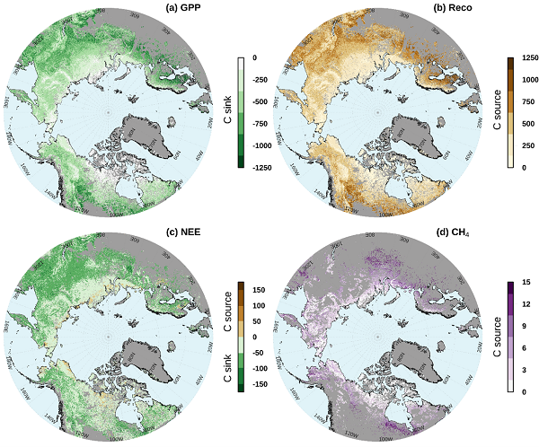
Gridded CO2 and CH4 Flux Estimates for pan-Arctic and Boreal Regions, 2003-2015
National Aeronautics and Space Administration —
This dataset provides gridded estimates of gross primary productivity (GPP), ecosystem respiration (Reco), net ecosystem CO2 exchange (NEE = Reco - GPP), and methane...

Official websites use .gov
A
.gov website belongs to an official government
organization in the United States.
Secure .gov websites use HTTPS
A
lock (
) or https:// means you’ve safely connected to
the .gov website. Share sensitive information only on official,
secure websites.