
-
Federal
Global Human Built-up And Settlement Extent (HBASE) Dataset From Landsat recent views
National Aeronautics and Space Administration —
The Global Human Built-up And Settlement Extent (HBASE) Dataset from Landsat is a global map of HBASE derived from the Global Land Survey (GLS) Landsat dataset for... -
Federal
VIIRS Plus DMSP Change in Lights (VIIRS+DMSP dLIGHT) recent views
National Aeronautics and Space Administration —
The VIIRS Plus DMSP Change in Lights (VIIRS+DMSP dLIGHT) data set fuses nighttime lights imagery from the U.S. Air Force Defense Meteorological Satellite Program... -
Federal
Tri-Decadal Global Landsat Orthorectified MSS 1-5 Single Scene: 1972-1987 recent views
Department of the Interior —
'The USGS Earth Resources Observation and Science (EROS) Center archive holds data collected by the Landsat suite of satellites, beginning with Landsat 1 in 1972. All... -
Federal
SHIFT: Ramses Trios Radiometer Above Water Measurements, Santa Barbara Sea, CA recent views
National Aeronautics and Space Administration —
This dataset provides calculated remote sensing reflectance (Rrs) from measurements collected with a Ramses TriOS radiometer deployed on the Santa Barbara Museum of... -
Federal
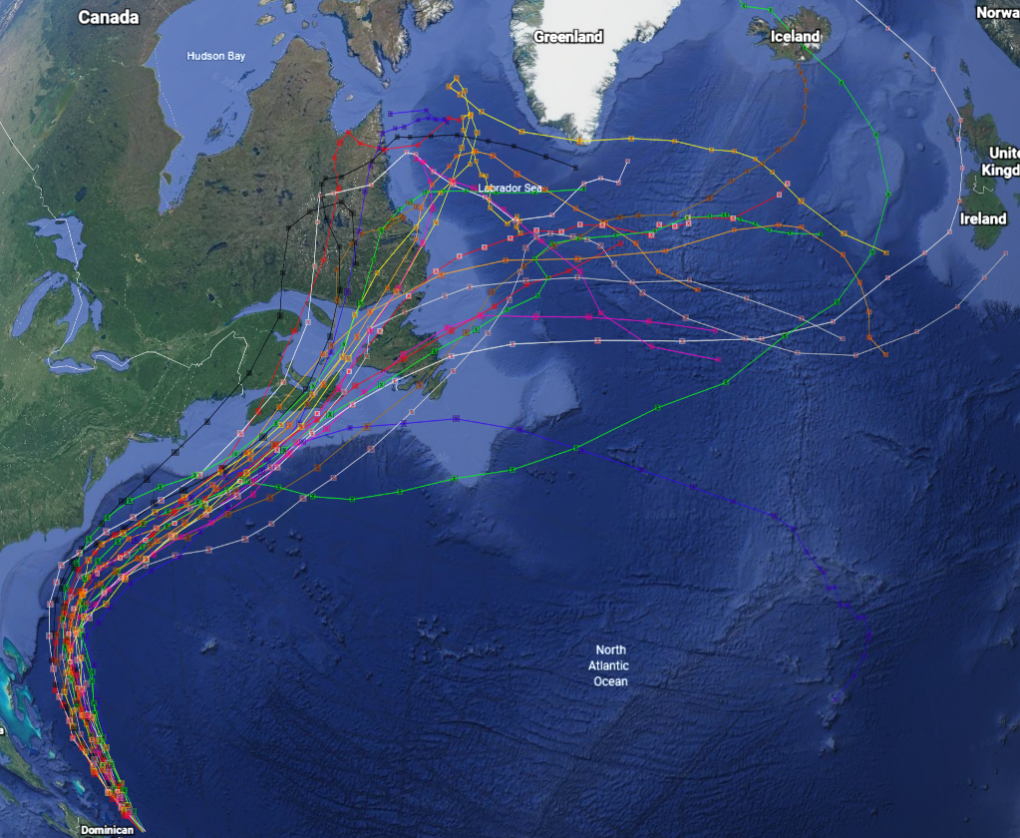
GRIP Hurricane and Tropical Storm Forecasts V1 recent views
National Aeronautics and Space Administration —
The GRIP Hurricane and Tropical Storm Forecasts dataset consists of tropical cyclone model forecast tracks archived during the NASA Genesis and Rapid Intensification... -
Federal
SMAPVEX12 Land Cover Classification Map V001 recent views
National Aeronautics and Space Administration —
This data set consists of land cover classification data derived from satellite imagery as part of the Soil Moisture Active Passive Validation Experiment 2012... -
Federal
ETM+ PAN (1999-2003) recent views
National Aeronautics and Space Administration —
Single scene Tri-Decadal Global Landsat Orthorectified MSS, TM, ETM+, and ETM+ Pan-sharpened data, which may be browsed, searched, and downloaded through... -
Federal
Amazon iNfluence on the Atlantic: CarbOn export from Nitrogen fixation by DiAtom Symbioses (ANACONDAS) recent views
National Aeronautics and Space Administration —
This research project sutided the effects of the Amazon River plume on the carbon and nitrogen cycling of the western tropical North Atlantic Ocean. Phytoplankton... -
Federal
Thematic Mapper (TM) Mosaics (1984-1997) recent views
National Aeronautics and Space Administration —
Mosaic data products, which are also available for Tri-Decadal Global Landsat Orthorectified TM and ETM+ Pan-sharpened data, and may be searched and downloaded... -
Federal
Tri-Decadal Global Landsat Orthorectified Enhanced ETM+ Pan-sharpened Single Scene: 1999-2003 recent views
Department of the Interior —
'The USGS Earth Resources Observation and Science (EROS) Center archive holds data collected by the Landsat suite of satellites, beginning with Landsat 1 in 1972. All... -
Federal
Retrospective analysis of anthropogenic change in Midwest reservoirs: Integrating earth observing data with statewide reservoir monitoring programs recent views
National Aeronautics and Space Administration —
The dataset comprises in-situ hyperspectral data acquired using the on-water approach (aka skylight-blocked approach), using a combination of a downwelling irradiance... -
Federal
Two-dimensional Velocities of Ice Mélange from Jakobshavn Isbræ, Greenland, Version 1 recent views
National Aeronautics and Space Administration —
This data set provides velocity components and resolved speeds for the proglacial ice mélange at Jakobshavn Glacier, Greenland. The data were collected using... -
Federal
Tri-Decadal Global Landsat Orthorectified TM Single Scene: 1984-1997 recent views
Department of the Interior —
'The USGS Earth Resources Observation and Science (EROS) Center archive holds data collected by the Landsat suite of satellites, beginning with Landsat 1 in 1972. ' -
Federal
Tri-Decadal Global Landsat Orthorectified ETM+ Systematically Corrected: 1999-2003 recent views
Department of the Interior —
'The U.S. Geological Survey (USGS) Earth Resources Observation and Science (EROS) Center archive holds data collected by the Landsat suite of satellites, beginning... -
Federal
Tri-Decadal Global Landsat Orthorectified ETM+ Single Scene: 1999-2003 recent views
Department of the Interior —
'The USGS Earth Resources Observation and Science (EROS) Center archive holds data collected by the Landsat suite of satellites, beginning with Landsat 1 in 1972. All... -
Federal
First ISCCP Regional Experiment (FIRE) Cirrus 1 Surface Radiation Budget (SRB) Shortwave Radiation Data recent views
National Aeronautics and Space Administration —
These data contain down-welled global shortwave hemispherical radiation taken during the Wisconsin FIRE/SRB experiment. The data set consists of measurement\ s taken... -
Federal
Global Man-made Impervious Surface (GMIS) Dataset From Landsat recent views
National Aeronautics and Space Administration —
The Global Man-made Impervious Surface (GMIS) Dataset From Landsat consists of global estimates of fractional impervious cover derived from the Global Land Survey... -
Federal
LBA-ECO LC-02 Tributary Coordinates, Acre River, Tri-national River Basin: 2003-2004 recent views
National Aeronautics and Space Administration —
This data set provides coordinates for points at the mouth of tributaries of the Acre River in the Tri-national River Basin in South America. Three Global Positioning... -
Federal
LBA-ECO LC-02 Hot Pixel Fire Indicator Data for Tri-national MAP Region: 2003-2006 NGDA recent views
National Aeronautics and Space Administration —
This data set provides hot pixel data, as an indicator of fires, that were detected by various satellites in the tri-national MAP region (Madre de Dios-Peru, Acre-...

Official websites use .gov
A
.gov website belongs to an official government
organization in the United States.
Secure .gov websites use HTTPS
A
lock (
) or https:// means you’ve safely connected to
the .gov website. Share sensitive information only on official,
secure websites.