
-
Federal
NACP Integrated Wildland and Cropland 30-m Fuel Characteristics Map, U.S.A., 2010
National Aeronautics and Space Administration —
The data set provides a 30-m comprehensive fuelbed characteristics map for both the wildland and cropland areas of the conterminous United States (CONUS) for 2010.... -
Federal
LBA-ECO LC-21 Selective Logging Activity in the Brazilian Amazon: 1999-2002
National Aeronautics and Space Administration —
This data set provides the results of analyses of Landsat Enhanced Thematic Mapper Plus (ETM+) images for selective logging activity in the Brazilian states of Para,... -
Federal
LBA-ECO LC-09 Land Cover Transitions Maps for Study Sites in Para, Brazil: 1970-2001
National Aeronautics and Space Administration —
This data set includes classified land cover transition maps at 30-m resolution derived from Landsat TM, MSS, ETM+ imagery and aerial photos of Altamira, Santarem,... -
Federal
NOAA/WDS Paleoclimatology - Margolis fire data from Twin Cabins plot 3, northern New Mexico - IMPD USTWC003
National Oceanic and Atmospheric Administration, Department of Commerce —
This archived Paleoclimatology Study is available from the NOAA National Centers for Environmental Information (NCEI), under the World Data Service (WDS) for... -
Federal
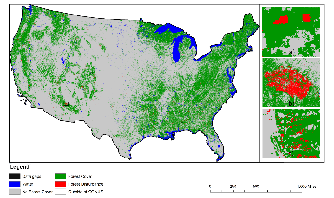
NACP NAFD Project: Forest Disturbance History from Landsat, 1986-2010
National Aeronautics and Space Administration —
The North American Forest Dynamics (NAFD) products provided in this data set consist of 25 annual and two time-integrated forest disturbance maps for the conterminous... -
Federal
NOAA/WDS Paleoclimatology - Heyerdahl fire data from Abajo Mountain - IMPD USABM001
National Oceanic and Atmospheric Administration, Department of Commerce —
This archived Paleoclimatology Study is available from the NOAA National Centers for Environmental Information (NCEI), under the World Data Service (WDS) for... -
Federal
NOAA/WDS Paleoclimatology - Margolis fire data from Los Griegos Plot 1, northern New Mexico - IMPD USLGR001
National Oceanic and Atmospheric Administration, Department of Commerce —
This archived Paleoclimatology Study is available from the NOAA National Centers for Environmental Information (NCEI), under the World Data Service (WDS) for... -
Federal
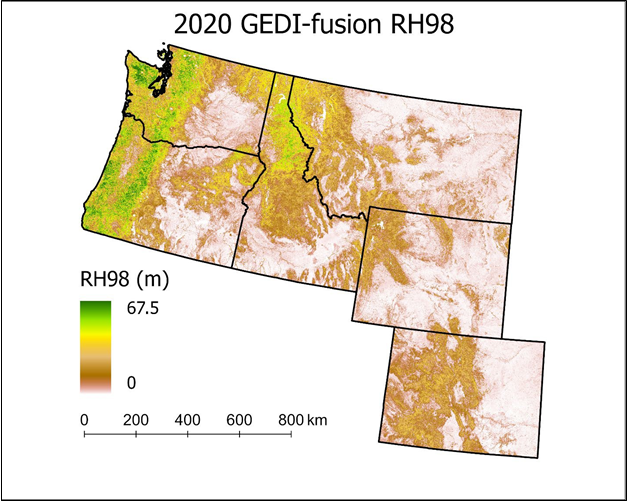
Gridded GEDI-Fusion Forest Structure Metrics across Six Western US States, 2016-2020
National Aeronautics and Space Administration —
This dataset provides eight GEDI forest structure metrics relevant to wildlife habitat modeling and biodiversity assessments at 30-m resolutions across Washington,... -
Federal
LiDAR Derived Forest Aboveground Biomass Maps, Northwestern USA, 2002-2016
National Aeronautics and Space Administration —
This dataset provides maps of aboveground forest biomass (AGB) of living trees and standing dead trees in Mg/ha across portions of Northwestern United States,... -
Federal
BOREAS RSS-17 Stem, Soil, and Air Temperature Data
National Aeronautics and Space Administration —
The BOREAS RSS-17 team collected several data sets in support of its research in monitoring and analyzing environmental and phenological states using radar data. This... -
Federal
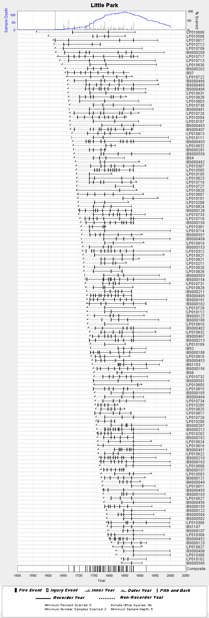
NOAA/WDS Paleoclimatology - Fulé fire data from Little Park - IMPD USLPK001
National Oceanic and Atmospheric Administration, Department of Commerce —
This archived Paleoclimatology Study is available from the NOAA National Centers for Environmental Information (NCEI), under the World Data Service (WDS) for... -
Federal
Forest Aboveground Biomass for Maryland, USA
National Aeronautics and Space Administration —
This dataset includes estimates of annual forest aboveground biomass over the state of Maryland, USA, for the period 1984-2023. It was generated by a modeling... -
Federal
Tree Mortality from Fires and Bark Beetles at 1-km Resolution, Western USA, 2003-2012
National Aeronautics and Space Administration —
This dataset provides annual estimates of tree mortality due to fires and bark beetles from 2003 to 2012 on forestland in the continental western United States. Tree... -
Federal
NOAA/WDS Paleoclimatology - Mundo fire data from Brazo Rico - Faldeo Los Notros, Patagonia - IMPD ARNOT001
National Oceanic and Atmospheric Administration, Department of Commerce —
This archived Paleoclimatology Study is available from the NOAA National Centers for Environmental Information (NCEI), under the World Data Service (WDS) for... -
Federal
NOAA/WDS Paleoclimatology - Veblen fire data from BM11 - IMPD USBM-011
National Oceanic and Atmospheric Administration, Department of Commerce —
This archived Paleoclimatology Study is available from the NOAA National Centers for Environmental Information (NCEI), under the World Data Service (WDS) for... -
Federal
CMS: Forest Carbon Stocks, Emissions, and Net Flux for the Conterminous US: 2005-2010
National Aeronautics and Space Administration —
This data set provides maps of estimated carbon in forests of the 48 continental states of the US for the years 2005-2010. Carbon (termed committed carbon) stocks... -
Federal
NOAA/WDS Paleoclimatology - Mundo fire data from RÃo Lácteo, Patagonia - IMPD ARLAC001
National Oceanic and Atmospheric Administration, Department of Commerce —
This archived Paleoclimatology Study is available from the NOAA National Centers for Environmental Information (NCEI), under the World Data Service (WDS) for... -
Federal
NOAA/WDS Paleoclimatology - Veblen fire data from BM8 - IMPD USBM-008
National Oceanic and Atmospheric Administration, Department of Commerce —
This archived Paleoclimatology Study is available from the NOAA National Centers for Environmental Information (NCEI), under the World Data Service (WDS) for... -
Federal
NOAA/WDS Paleoclimatology - Heyerdahl fire data from Southside Trail, Palouse northwestern United States - IMPD USSST001
National Oceanic and Atmospheric Administration, Department of Commerce —
This archived Paleoclimatology Study is available from the NOAA National Centers for Environmental Information (NCEI), under the World Data Service (WDS) for...

Official websites use .gov
A
.gov website belongs to an official government
organization in the United States.
Secure .gov websites use HTTPS
A
lock (
) or https:// means you’ve safely connected to
the .gov website. Share sensitive information only on official,
secure websites.