

24 datasets found for "River Subbasin"
-
State
2019 California Water Quality Status Report
State of California —
The California Water Quality Status Report is an annual data-driven snapshot of the Water Board’s water quality and ecosystem data. This third edition of the report... -
State
DWR Airborne Electromagnetic (AEM) Surveys Data
State of California —
Statewide AEM Surveys Project Overview The Department of Water Resources’ (DWR’s) Statewide Airborne Electromagnetic (AEM) Surveys Project is funded through... -
Federal
LBA-ECO CD-06 Water Balance of the Ji-Parana River Basin, Brazil: 1995-1996
National Aeronautics and Space Administration —
This data set provides simulated minimum, average, and maximum monthly rainfall, potential evapotranspiration, water deficit, and water surplus values for the Ji-... -
State
WBDLine NGDA
State of Oregon —
Abstract: This file contains Hydrologic Unit (HU) polygon boundaries for the United States, Puerto Rico, and the U.S. Virgin Islands. The data is a seamless National... -
State
14-digit HU NGDA
State of Oregon —
Abstract: This file contains Hydrologic Unit (HU) polygon boundaries for the United States, Puerto Rico, and the U.S. Virgin Islands. The data is a seamless National... -
State
Oregon Channel Migration
State of Oregon —
Channel migration is the natural process by which streams move laterally over time. It is typically a gradual phenomenon that works over many years to effect... -
State
10-digit HU (Watershed) NGDA
State of Oregon —
Abstract: This file contains Hydrologic Unit (HU) polygon boundaries for the United States, Puerto Rico, and the U.S. Virgin Islands. The data is a seamless National... -
State
16-digit HU NGDA
State of Oregon —
Abstract: This file contains Hydrologic Unit (HU) polygon boundaries for the United States, Puerto Rico, and the U.S. Virgin Islands. The data is a seamless National... -
State
Eelgrass Beds 2009 Points
State of Connecticut —
Eelgrass Beds 2009 Set: This data layer was created by the Conservation Management Institute, Virginia Tech University for the USFWS National Wetlands Inventory,... -
State
Salmonid Population Monitoring Areas - California - CMP [ds3001]
State of California —
The California Monitoring Plan (CMP) salmonid monitoring areas and associated population data are part of an ongoing effort to summarize existing and past salmonid... -
State
Eelgrass Beds 2012 Polygon
State of Connecticut —
Eelgrass Beds 2012 Polygon : This data layer was created by the Conservation Management Institute, Virginia Tech University for the USFWS National Wetlands Inventory,... -
State
6-digit HU (Basin) NGDA
State of Oregon —
Abstract: This file contains Hydrologic Unit (HU) polygon boundaries for the United States, Puerto Rico, and the U.S. Virgin Islands. The data is a seamless National... -
State
12-digit HU (Subwatershed) NGDA
State of Oregon —
Abstract: This file contains Hydrologic Unit (HU) polygon boundaries for the United States, Puerto Rico, and the U.S. Virgin Islands. The data is a seamless National... -
State
8-digit HU (Subbasin) NGDA
State of Oregon —
Abstract: This file contains Hydrologic Unit (HU) polygon boundaries for the United States, Puerto Rico, and the U.S. Virgin Islands. The data is a seamless National... -
State
Eelgrass Beds 2009 Polygon
State of Connecticut —
Eelgrass Beds 2009 Set: This data layer was created by the Conservation Management Institute, Virginia Tech University for the USFWS National Wetlands Inventory,... -
State
Salmonid Population Monitoring Areas - California - CMP [ds3001] Extended Table
State of California —
The California Monitoring Plan (CMP) salmonid monitoring areas and associated population data are part of an ongoing effort to summarize existing and past salmonid... -
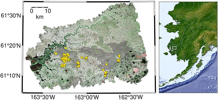
Federal
CO2 and CH4 Fluxes from Waterbodies, Yukon-Kuskokwim Delta, Alaska, 2016-2019
National Aeronautics and Space Administration —
This dataset provides estimates of carbon dioxide (CO2) and methane (CH4) diffusive fluxes from waterbodies, and watershed landcover data for the central-interior of... -
State
Salmonid Population Monitoring Areas - California - CMP [ds3001]
State of California —
The California Monitoring Plan (CMP) salmonid monitoring areas and associated population data are part of an ongoing effort to summarize existing and past salmonid... -
Watersheds
District of Columbia —
This data set consists of geo-referenced digital data and associated attributes created in accordance with the FGDC Proposal, Version 1.0 - Federal Standards For... -
State
Salmonid Population Monitoring Areas - California - CMP [ds3001]
State of California —
The California Monitoring Plan (CMP) salmonid monitoring areas and associated population data are part of an ongoing effort to summarize existing and past salmonid...
24 datasets found for "River Subbasin"