
-
State
National Hydrography Data - NHD and 3DHP recent views
State of California —
The USGS National Hydrography Dataset (NHD) Downloadable Data Collection from The National Map (TNM) is a comprehensive set of digital spatial data that encodes... -
Federal
From Past to Present: Ecosystem Services and People of the Guana Peninsula - NERRS/NSC(NERRS Science Collaborative) recent views
National Oceanic and Atmospheric Administration, Department of Commerce —
For over 6,000 years, people have called the Guana Peninsula home, largely due to the bountiful resources of the estuary. These resources, both natural and cultural,... -
Federal
NOAA ENC Direct to GIS recent views
National Oceanic and Atmospheric Administration, Department of Commerce —
NOAA's Electronic Navigational Charts (NOAA ENCs) have been developed to support the marine transportation infrastructure and coastal management. The NOAA ENCs are in... -
Federal
Digital Geologic-GIS Map of Pipestone National Monument, Minnesota (NPS, GRD, GRI, PIPE, PIPE digital map) adapted from a National Park Service, Midwest Region unpublished digital data and map (1997), and a National Park Service unpublished map by Morey (1983) recent views
Department of the Interior —
The Digital Geologic-GIS Map of Pipestone National Monument, Minnesota is composed of GIS data layers and GIS tables, and is available in the following GRI-supported... -
Federal
Evaluation of a high-throughput H295R homogenous time resolved fluorescence assay for androgen and estrogen steroidogenesis screening recent views
U.S. Environmental Protection Agency —
Dataset for 'Evaluation of a high-throughput H295R homogenous time resolved fluorescence assay for androgen and estrogen steroidogenesis screening', Garnovskaya, et... -
Federal
OCO-3 Level 2 CO2 prior based on CO2 monthly flask record, global meteorology, and age of air, Forward Processing V10 (OCO3_L2_CO2Prior) at GES DISC recent views
National Aeronautics and Space Administration —
Version 10 is the current version of the data set. Older versions will no longer be available and are superseded by Version 10. The Orbiting Carbon Observatory -3... -
Federal
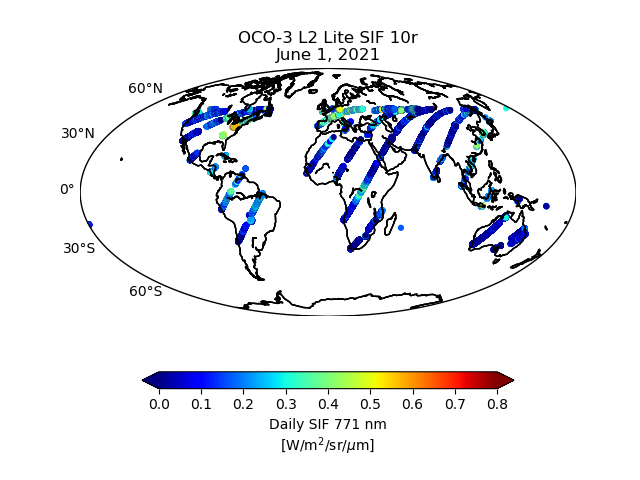
OCO-3 Level 2 bias-corrected solar-induced fluorescence and other select fields from the IMAP-DOAS algorithm aggregated as daily files, Retrospective processing V10r (OCO3_L2_Lite_SIF) at GES DISC recent views
National Aeronautics and Space Administration —
Version 10r is the current version of the data set. Older versions will no longer be available and are superseded by Version 10r. The Orbiting Carbon Observatory -3... -
Federal
Refugio Marine Mammal Survey (June 4, 2015) recent views
National Oceanic and Atmospheric Administration, Department of Commerce —
On May 19, 2015, a pipeline owned ruptured in Santa Barbara County, California, near Refugio State Beach. An estimated 21,000 gallons of the oil flowed overland from... -
Federal
Maine and New Hampshire 2016 SOCECON_POLY (Socioeconomic Resource Polygons) recent views
National Oceanic and Atmospheric Administration, Department of Commerce —
This data set contains vector polygons depicting locations for Pipelines for Maine and New Hampshire. Location-specific type and source information are stored in... -
Federal
Refugio Wildlife Observations Overflight Track Line - 21 May 2015 @1400 hours (Flight 1) recent views
National Oceanic and Atmospheric Administration, Department of Commerce —
On May 19, 2015, a pipeline owned ruptured in Santa Barbara County, California, near Refugio State Beach. An estimated 21,000 gallons of the oil flowed overland from... -
Federal
Ground-Based Vegetation Community Photos, Toolik Lake Area, Alaska, 2014-2015 recent views
National Aeronautics and Space Administration —
This dataset contains 731 ground-based nadir vegetation community and ground surface photographs of selected field plots taken as ground reference data for vegetation... -
Federal
OCO-2 Level 2 spatially ordered geolocated retrievals screened using the IMAP-DOAS Preprocessor (IDP) V11.2 (OCO2_L2_IMAPDOAS) at GES DISC recent views
National Aeronautics and Space Administration —
Version 11.2 is the current version of the data set. Older versions will no longer be available and are superseded by Version 11.2. The Orbiting Carbon Observatory is... -
Federal
OCO-3 Level 2 spatially ordered geolocated retrievals screened using the IMAP-DOAS Preprocessor (IDP), Forward Processing V10 (OCO3_L2_IMAPDOAS) at GES DISC recent views
National Aeronautics and Space Administration —
Version 10 is the current version of the data set. Older versions will no longer be available and are superseded by Version 10. The Orbiting Carbon Observatory -3... -
Federal
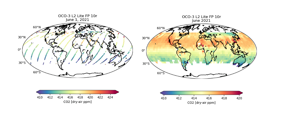
OCO-3 Level 2 bias-corrected XCO2 and other select fields from the full-physics retrieval aggregated as daily files, Retrospective processing v10.4r (OCO3_L2_Lite_FP) at GES DISC recent views
National Aeronautics and Space Administration —
Version 10.4r is the current version of the data set. Older versions will no longer be available and are superseded by Version 10.4r. The Orbiting Carbon Observatory... -
Federal
OCO-3 Level 2 geolocated XCO2 retrieval results and algorithm diagnostic information, Retrospective Processing V10r (OCO3_L2_Diagnostic) at GES DISC recent views
National Aeronautics and Space Administration —
Version 10r is the current version of the data set. Older versions will no longer be available and are superseded by Version 10r. The Orbiting Carbon Observatory -3... -
Federal
OCO-3 Level 2 geolocated XCO2 retrieval results and algorithm diagnostic information, Forward Processing V10 (OCO3_L2_Diagnostic) at GES DISC recent views
National Aeronautics and Space Administration —
Version 10 is the current version of the data set. Older versions will no longer be available and are superseded by Version 10. The Orbiting Carbon Observatory -3... -
Federal
BSEE Data Center - Gulf of Mexico Region Pipeline Segment List by Segment Number recent views
Department of the Interior —
This data set contains Gulf of Mexico Region Pipeline Segment List by Segment Number. -
Federal
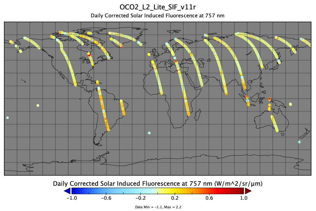
OCO-2 Level 2 bias-corrected solar-induced fluorescence and other select fields from the IMAP-DOAS algorithm aggregated as daily files, Retrospective processing V11r (OCO2_L2_Lite_SIF) at GES DISC recent views
National Aeronautics and Space Administration —
Version 11r is the current version of the data set. Older versions will no longer be available and are superseded by Version 11r. The OCO-2 SIF Lite files contain... -
Federal
Refugio Western Snowy Plover Nesting Locations recent views
National Oceanic and Atmospheric Administration, Department of Commerce —
On May 19, 2015, a pipeline owned ruptured in Santa Barbara County, California, near Refugio State Beach. An estimated 21,000 gallons of the oil flowed overland from... -
Federal
Refugio GNOME NRDA Trajectory May 20 recent views
National Oceanic and Atmospheric Administration, Department of Commerce —
On May 19, 2015, a pipeline owned ruptured in Santa Barbara County, California, near Refugio State Beach. An estimated 21,000 gallons of the oil flowed overland from...

Official websites use .gov
A
.gov website belongs to an official government
organization in the United States.
Secure .gov websites use HTTPS
A
lock (
) or https:// means you’ve safely connected to
the .gov website. Share sensitive information only on official,
secure websites.