

214 datasets found for "Pipelines"
-
Federal
Oil and Gas Pipelines in the Gulf of Mexico from BOEM
National Oceanic and Atmospheric Administration, Department of Commerce —
A line file representing locations of the pipeline infrastructure in the Gulf of Mexico associated with the oil and gas industry is presented. These layers were... -
State
California Power Plants
State of California —
The power plant locations and characteristics are part of the California Energy Commission’s (CEC) California Energy Infrastructure geospatial data sets. The data is... -
Federal
Right of Way (Feature Layer)
Department of Agriculture —
An area depicting a privilege to pass over the land of another in some particular path; usually an easement over the land of another; a strip of land used in this way... -
Federal
Hazmat Approvals
Department of Transportation —
The Pipeline and Hazardous Materials Safety Administration has the primary responsibility for the issuance of DOT Special Permits and Approvals to the Hazardous... -
Federal
Hazmat Yearly Incident Summary Reports
Department of Transportation —
Series of Incident data and summary statistics reports produced which provide statistical information on incidents by type, year, geographical location, and others.... -
City
Water Mains
City of Seattle —
A grouped feature layer that includes Water Mains, Water Services, Same Side Tap Only and No New Taps layers.Water Mains are large buried pipes that distribute water... -
Federal
BLM AK Fiber Optics/Telephone LUA
Department of the Interior —
The land use authorization dataset includes the following authorization types: communication sites, facility/site, fiber optics/telephone, lease/permit, pipeline,... -
Federal
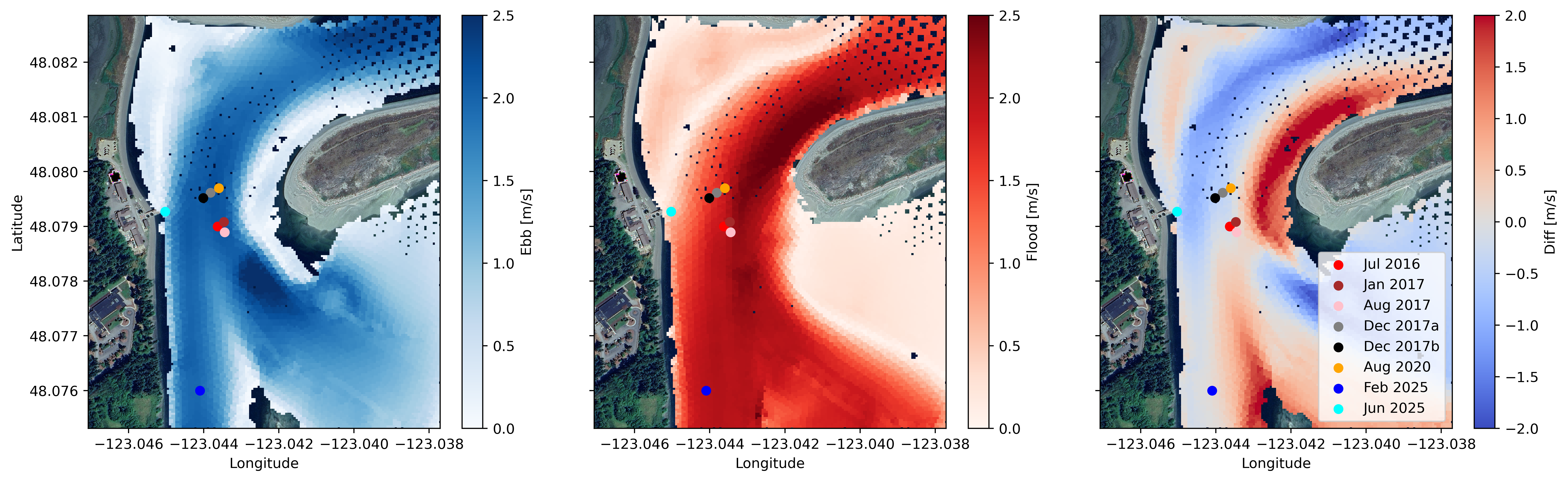
Water Velocity and Turbulence Data from Sequim Bay, WA, 2016 - 2025
Department of Energy —
Collection of publishable datasets from bottom-lander deployments of acoustic Doppler instrumentation in Sequim Bay, WA measured between 2016 and 2025. These data... -
City
Housing Database
City of New York —
The NYC Department of City Planning’s (DCP) Housing Database contains all NYC Department of Buildings (DOB) approved housing construction and demolition jobs filed... -
Federal
Milky Way Star Clusters Catalog
National Aeronautics and Space Administration —
Although they are the main constituents of the Galactic disk population, for half of the open clusters in the Milky Way reported in the literature nothing is known... -
Federal
Refugio Marine Mammal Survey (June 3, 2015)
National Oceanic and Atmospheric Administration, Department of Commerce —
On May 19, 2015, a pipeline owned ruptured in Santa Barbara County, California, near Refugio State Beach. An estimated 21,000 gallons of the oil flowed overland from... -
Federal
OCO-3 Level 1B calibrated, geolocated science spectra, Forward Processing V10 (OCO3_L1B_Science) at GES DISC
National Aeronautics and Space Administration —
Version 10 is the current version of the data set. Older versions will no longer be available and are superseded by Version 10. The Orbiting Carbon Observatory -3... -
Federal
BLM AK Water LUA
Department of the Interior —
The land use authorization dataset includes the following authorization types: communication sites, facility/site, fiber optics/telephone, lease/permit, pipeline,... -
Federal
Drug and Alcohol Management Information System Report (DAMIS)
Department of Transportation —
PHMSA regulations in 49 CFR Part 199 require operators of pipelines, liquefied natural gas plants, and underground natural gas storage facilities to submit data to... -
Federal
Brady's Geothermal Field DAS Vibroseis Data
Department of Energy —
The submitted data correspond to the monitored vibrations caused by a vibroseis seismically exciting the ground in the vertical direction and captured by the DAS... -
Federal
eROSITA All-Sky Survey Master Catalog
National Aeronautics and Space Administration —
The eROSITA-DE DR1 comprises data from the first six months of the SRG/eROSITA all-sky survey (eRASS1) whose proprietary rights lie with the German eROSITA... -
Federal
Near-real-time surface ocean velocities derived from HF-radar stations located along coastal waters of North Slope Alaska, Gulf of Alaska, Puerto Rico/Virgin Islands, eastern U.S./Gulf of America, Hawaii, Great Lakes, and western U.S.
National Oceanic and Atmospheric Administration, Department of Commerce —
This dataset contains near-real-time ocean surface velocities, also known as total vector velocities, derived from high-frequency (HF) radar stations. The velocities... -
Federal
BLM ID Range Improvements Poly
Department of the Interior —
This geodatabase of point, line and polygon features is an effort to consolidate all of the range improvement locations on BLM-managed land in Idaho into one... -
Federal
Whole Genome Shotgun Submissions
U.S. Department of Health & Human Services —
Whole Genome Shotgun (WGS) projects are genome assemblies of incomplete genomes or incomplete chromosomes of prokaryotes or eukaryotes that are generally being...
214 datasets found for "Pipelines"