
-
Federal
CeNCOOS in situ water quality monitoring at Monterey Bay Commercial Wharf
National Oceanic and Atmospheric Administration, Department of Commerce —
The Monterey shore station is maintained by Moss Landing Marine Labs. The station has been operational since 2012 and consists of in water sensors that are fixed to a... -
Federal
CalHABMAP - HABs Bodega Marine Lab Buoy data
National Oceanic and Atmospheric Administration, Department of Commerce —
The California Harmful Algal Bloom Monitoring and Alert Program (CalHABMAP) collects weekly phytoplankton and water quality data at eight piers along the Central and... -
Federal
Summary of recreational hook and line caught sea turtles documented by the NOAA Galveston Laboratory
National Oceanic and Atmospheric Administration, Department of Commerce —
The database is a summary of sea turtles that are hook and line captured by recreational anglers in the region covered by the NOAA Galveston Laboratory through its... -
Federal
073 - Scripps Pier, La Jolla, CA (LJPC1)
National Oceanic and Atmospheric Administration, Department of Commerce —
Timeseries data from '073 - Scripps Pier, La Jolla, CA (LJPC1)' (edu_ucsd_cdip_073) -
Federal
Non-commercial Boat-based Line Fishing Estimated Average Annual Catch of Reef Fish, 2004-2013 - Hawaii
National Oceanic and Atmospheric Administration, Department of Commerce —
Nearshore fisheries in the Main Hawaiian Islands encompass a diverse group of fishers using a wide array of gears and targeting many different species. Communities in... -
Federal
D00220: NOS Hydrographic Survey , 2016-11-01
National Oceanic and Atmospheric Administration, Department of Commerce —
The National Oceanic and Atmospheric Administration (NOAA) has the statutory mandate to collect hydrographic data in support of nautical chart compilation for safe... -
Federal
F00789: NOS Hydrographic Survey , 2019-10-25
National Oceanic and Atmospheric Administration, Department of Commerce —
The National Oceanic and Atmospheric Administration (NOAA) has the statutory mandate to collect hydrographic data in support of nautical chart compilation for safe... -
Federal
Cherry Grove Pier
National Oceanic and Atmospheric Administration, Department of Commerce —
Timeseries data from 'Cherry Grove Pier' (cherry-grove-pier) -
Federal
F00775: NOS Hydrographic Survey , 2019-06-04
National Oceanic and Atmospheric Administration, Department of Commerce —
The National Oceanic and Atmospheric Administration (NOAA) has the statutory mandate to collect hydrographic data in support of nautical chart compilation for safe... -
Federal
Assessment of invasiveness of the Orange Keyhole Sponge, Mycale Armata, in Kaneohe Bay Oahu, Hawaii, based on surveys 2004-2005 (NCEI Accession 0002602)
National Oceanic and Atmospheric Administration, Department of Commerce —
The Orange Keyhole Sponge, Mycale armata Thiele, was unknown in Hawaii prior to 1996. First reported in Pearl Harbor, it now occurs in virtually every commercial... -
Federal
PacIOOS Nearshore Sensor 016: Wailupe, Oahu, Hawaii
National Oceanic and Atmospheric Administration, Department of Commerce —
The nearshore sensors are part of the Pacific Islands Ocean Observing System (PacIOOS) and are designed to measure a variety of ocean parameters at fixed points.... -
Federal
CalHABMAP - HABs Morro Bay Front Bay data
National Oceanic and Atmospheric Administration, Department of Commerce —
The California Harmful Algal Bloom Monitoring and Alert Program (CalHABMAP) collects weekly phytoplankton and water quality data at eight piers along the Central and... -
Federal
H13092: NOS Hydrographic Survey , 2017-11-09
National Oceanic and Atmospheric Administration, Department of Commerce —
The National Oceanic and Atmospheric Administration (NOAA) has the statutory mandate to collect hydrographic data in support of nautical chart compilation for safe... -
Federal
CO-OPS station 9414863: RICHMOND, CHEVRON OIL PIER 1-minute Raw Tsunami Water Level Data
National Oceanic and Atmospheric Administration, Department of Commerce —
CO-OPS has been involved with tsunami warning and mitigation since the Coast and Geodetic Survey started the Tsunami Warning System in 1948 to provide warnings to the... -
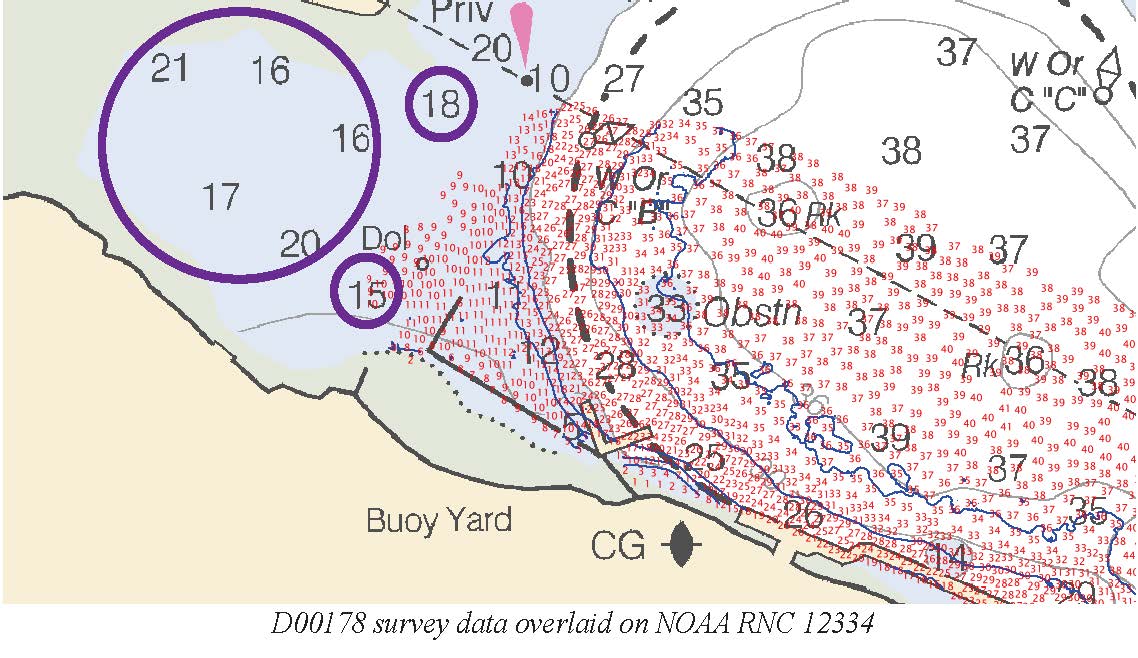
Federal
D00178: NOS Hydrographic Survey , 2013-04-29
National Oceanic and Atmospheric Administration, Department of Commerce —
The National Oceanic and Atmospheric Administration (NOAA) has the statutory mandate to collect hydrographic data in support of nautical chart compilation for safe... -
Federal
Apache Pier
National Oceanic and Atmospheric Administration, Department of Commerce —
Timeseries data from 'Apache Pier' (apache-pier) -
Federal
D00243: NOS Hydrographic Survey , 2017-12-07
National Oceanic and Atmospheric Administration, Department of Commerce —
The National Oceanic and Atmospheric Administration (NOAA) has the statutory mandate to collect hydrographic data in support of nautical chart compilation for safe... -
Federal
H13810: NOS Hydrographic Survey , 2023-10-03
National Oceanic and Atmospheric Administration, Department of Commerce —
The National Oceanic and Atmospheric Administration (NOAA) has the statutory mandate to collect hydrographic data in support of nautical chart compilation for safe... -
Federal
SCCOOS Automated Shore Station - Newport Beach Pier
National Oceanic and Atmospheric Administration, Department of Commerce —
Timeseries data from 'Newport Beach Pier Automated Shore Station' (newport-pier-automated-shore-sta) -
Federal
PacIOOS Ocean Gliders: SeaGlider 139: Mission 7
National Oceanic and Atmospheric Administration, Department of Commerce —
As a part of PacIOOS, ocean gliders provide very detailed information about the physical and chemical condition of the waters around the Hawaiian Islands....

Official websites use .gov
A
.gov website belongs to an official government
organization in the United States.
Secure .gov websites use HTTPS
A
lock (
) or https:// means you’ve safely connected to
the .gov website. Share sensitive information only on official,
secure websites.