
-
Federal
Airborne Electromagnetic Survey Processed Data and Models Data Release, Yellowstone National Park, Wyoming, 2016
Department of the Interior —
Airborne electromagnetic (AEM) and magnetic survey data were collected during November and December 2016 along 4,212 line-kilometers over Yellowstone National Park,... -
Federal
Gazetteer of Planetary Nomenclature: Uranian System: Ariel
National Aeronautics and Space Administration —
These images display several of Uranus's moons approved by the International Astronomical Union (IAU). -
Federal
Gazetteer of Planetary Nomenclature: Saturnian System: Tethys
National Aeronautics and Space Administration —
These images display several of Saturn's moons approved by the International Astronomical Union (IAU). -
Federal
Gazetteer of Planetary Nomenclature: Saturnian System: Phoebe
National Aeronautics and Space Administration —
These images display several of Saturn's moons approved by the International Astronomical Union (IAU). -
Federal
Gazetteer of Planetary Nomenclature: Saturnian System: Titan
National Aeronautics and Space Administration —
These images display several of Saturn's moons approved by the International Astronomical Union (IAU). -
Federal
Gazetteer of Planetary Nomenclature: Moon: 1:10 million-scale Shaded Relief and Color-coded Topography: South Pole
National Aeronautics and Space Administration —
These lunar maps display the four different areas of the moon with color-coded topography in low and high resolution approved by the International Astronomical Union... -
Federal
Gazetteer of Planetary Nomenclature: Mars: Phobos names with images and Deimos
National Aeronautics and Space Administration —
These images display the two moons of Mars: Deimos and Phobos - with HRSC images and shaded relief images with cylindrical and hemispherical views approved by the... -
Federal
Gazetteer of Planetary Nomenclature: Jovian System: Callisto
National Aeronautics and Space Administration —
These images display several of Jupiter's moons approved by the International Astronomical Union (IAU). -
Federal
Earth Resources Observation and Science (EROS) Center's Landsat State Mosaics Gallery
National Aeronautics and Space Administration —
The Earth Resources Observation and Science (EROS) Center manages the this gallery of images of the 50 U.S. states plus Puerto Rico as derived by Landsat data. -
Federal
Gazetteer of Planetary Nomenclature: Jovian System: Amalthea
National Aeronautics and Space Administration —
These images display several of Jupiter's moons approved by the International Astronomical Union (IAU). -
Federal
Gazetteer of Planetary Nomenclature: Mercury: 1:5 million-scale
National Aeronautics and Space Administration —
The purpose of this set of maps is to provide an up-to-date source showing the locations of Mercury surface feature names approved by the International Astronomical... -
Federal
Gazetteer of Planetary Nomenclature: Moon: 1:1 million-scale maps of the Moon
National Aeronautics and Space Administration —
The purpose of the lunar maps is to provide an up-to-date and comprehensive depiction on lunar nomenclature approved by the International Astronomical Union (IAU). -
Federal
Gazetteer of Planetary Nomenclature: Venus: 1:10 million-scale Altimetry Quadrangles: Guinevere
National Aeronautics and Space Administration —
This set of maps diplays altimetric radar images of Venus approved by the International Astronomical Union (IAU). -
Federal
Gazetteer of Planetary Nomenclature: Saturnian System: Janus
National Aeronautics and Space Administration —
These images display several of Saturn's moons approved by the International Astronomical Union (IAU). -
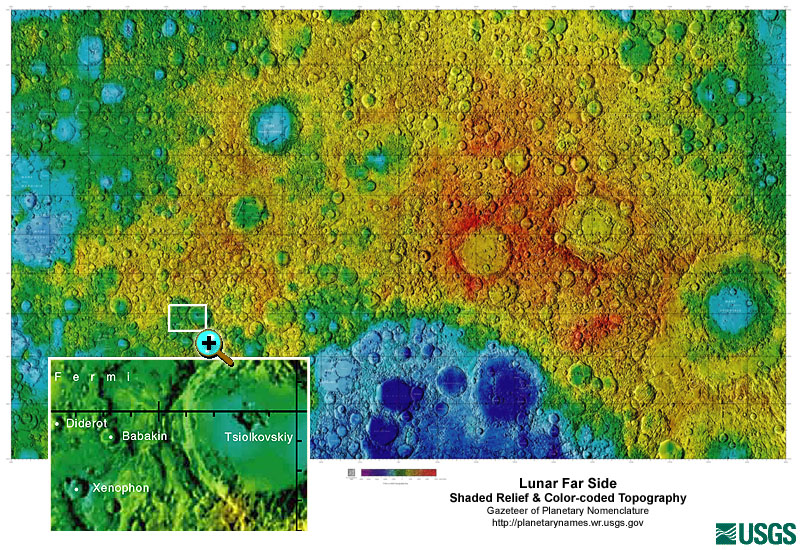
Federal
Gazetteer of Planetary Nomenclature: Moon: 1:10 million-scale Shaded Relief and Color-coded Topography: Far Side
National Aeronautics and Space Administration —
These lunar maps display the four different areas of the moon with color-coded topography in low and high resolution approved by the International Astronomical Union... -
Federal
Gazetteer of Planetary Nomenclature: Saturnian System: Enceladus
National Aeronautics and Space Administration —
These images display several of Saturn's moons approved by the International Astronomical Union (IAU). -
Federal
Shoreline change data along the coast of California from 2015 to 2016
Department of the Interior —
This dataset contains shoreline change measurements for sandy beaches along the coast of California over the 2015/2016 El Nino winter season. Mean high water (MHW)... -
Federal
Aerial imagery from UAS survey of the intertidal zone at Puget Creek and Dickman Mill Park, Tacoma, WA, 2019-06-03
Department of the Interior —
This portion of the data release presents the raw aerial imagery collected during an Unmanned Aerial System (UAS) survey of the intertidal zone at Puget Creek and... -
Federal
Gazetteer of Planetary Nomenclature: Venus: 1:5 million-scale Magellan Imagery
National Aeronautics and Space Administration —
Magellan imagery of Venus approved by the International Astronomical Union (IAU). -
Federal
Gazetteer of Planetary Nomenclature: Venus: 1:10 million-scale Altimetry Quadrangles: Sedna
National Aeronautics and Space Administration —
This set of maps diplays altimetric radar images of Venus approved by the International Astronomical Union (IAU).

Official websites use .gov
A
.gov website belongs to an official government
organization in the United States.
Secure .gov websites use HTTPS
A
lock (
) or https:// means you’ve safely connected to
the .gov website. Share sensitive information only on official,
secure websites.