

19 datasets found for "Landfill"
-
State
California Power Plants
State of California —
The power plant locations and characteristics are part of the California Energy Commission’s (CEC) California Energy Infrastructure geospatial data sets. The data is... -
State
Landfills
Vermont Center for Geographic Information —
This data set defines both current and historic landfills/waste disposal storage sites for the State of Vermont. Historic landfills were identified with the... -
Federal
Food Waste Management Life Cycle Inventory Tool v1.0.0
U.S. Environmental Protection Agency —
This Excel-based life cycle inventory (LCI) model develops LCI data for management of wasted food via anaerobic digestion (AD), windrow and aerated static pile (ASP)... -
City
ECA Landfills Historical
City of Seattle —
Displays Environmentally Critical Areas (ECA) in the City of Seattle. For more information about the definition of the ECA layers, see Seattle Municipal Code section... -
State
hazardouswastesites
State of California —
This Feature Layer Collection contains publicly shared data from Envirostor, the Department of Toxic Substances Control's Project Management Solution. The data... -
Federal
EPA Facility Registry Service (FRS): ER_CERCLIS
U.S. Environmental Protection Agency —
This web feature service contains location and facility identification information from EPA's Facility Registry System (FRS) for the subset of facilities that link to... -
City
ECA Landfills Historical
City of Seattle —
Displays historic landfill locations.A polygon feature class showing landfill areas and former landfill sites. Used to implement and regulate the City of Seattle's... -
Federal
Sources of Methane Emissions (Vista-LA), South Coast Air Basin, California, USA
National Aeronautics and Space Administration —
This data set provides spatial data products with identified and classified locations of potential methane (CH4) emitting facilities and infrastructure in the South... -
State
ICEsites
State of California —
This Feature Layer Collection contains publicly shared data from Envirostor, the Department of Toxic Substances Control's Project Management Solution. The data... -
State
Chronic Wasting Disease Lined Landfills for Deer Carcass Disposal - CDFW [ds3156]
State of California —
This compilation of layers provides a comprehensive view of CWD-related activities, facilitating informed decision-making and strategic planning for wildlife... -
State
cleanupsites
State of California —
This Feature Layer Collection contains publicly shared data from Envirostor, the Department of Toxic Substances Control's Project Management Solution. The data... -
Federal
Fluvial flooding and sea-level rise datasets related to benzo[a]pyrene transport at the Lower Darby Creek Area
U.S. Environmental Protection Agency —
Datasets include maps and excel spreadsheet data files used in modeling the combined impacts of fluvial flooding, mean higher high water tide, and sea level rise on... -
Federal
Boundaries of EPA R6 NPL Sites as of 3/1/2023; EPA Region 6 Superfund, AR, LA, NM, OK, TX
U.S. Environmental Protection Agency —
This layer contains boundaries of EPA Region 6 Superfund NPL Sites as of 3/1/2023. The boundaries represent several types of features such as operable units, plumes,... -
City
4.04 Solid Waste Landfill Diversion (summary)
City of Tempe —
This page provides data for the Solid Waste Landfill Diversion performance measure. The performance measure dashboard is available at 4.04 Solid Waste Landfill... -
Federal
Sources of Methane Emissions (Vista-CA), State of California, USA
National Aeronautics and Space Administration —
This dataset provides spatial data products with identified and organized locations of potential methane (CH4) emitting facilities and infrastructure spanning the... -
Federal
COMEX: AMOG Surface Mobile in situ Data Surveyor, USA, 2014-2015
National Aeronautics and Space Administration —
This dataset provides AutoMObile trace Gas Surveyor (AMOG) in situ relevant datasets collected during the CO2 and Methane EXperiment (COMEX) field campaign and... -
Federal
NACP MCI: CO2 Emissions Inventory, Upper Midwest Region, USA., 2007
National Aeronautics and Space Administration —
This data set provides a bottom-up CO2 emissions inventory for the mid-continent region of the United States for the year 2007. The study was undertaken as part of... -
Federal
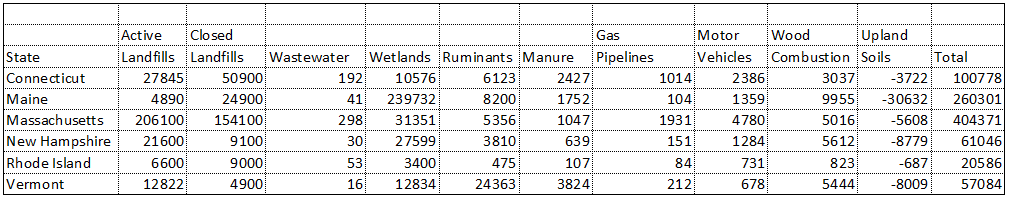
Natural and Anthropogenic Methane Sources, New England, USA, 1990-1994
National Aeronautics and Space Administration —
This data set contains an inventory of natural and anthropogenic methane emissions for all counties in the six New England states of Connecticut, Rhode Island,...
19 datasets found for "Landfill"