
-
Federal
High-Fidelity Simulation Aerodynamics Dataset of NACA 0012 and 0021 Airfoils
Department of Energy —
The repository contains time series data of pressure, viscous and moment forces for the NACA 0012 and 0021 airfoils at angles of attack (AOA), 5, 17, 30, 45, 60 and... -
Federal
GPM IMERG Final Precipitation L3 1 day 0.1 degree x 0.1 degree V07 (GPM_3IMERGDF) at GES DISC
National Aeronautics and Space Administration —
Version 07 is the current version of the data set. Older versions will no longer be available and have been superseded by Version 07.The Integrated Multi-satellitE... -
Federal
Snow Melt Onset Over Arctic Sea Ice from SMMR and SSM/I-SSMIS Brightness Temperatures, Version 5
National Aeronautics and Space Administration —
This data set includes yearly snow melt onset dates over Arctic sea ice derived from Scanning Multichannel Microwave Radiometer (SMMR), Special Sensor... -
Federal
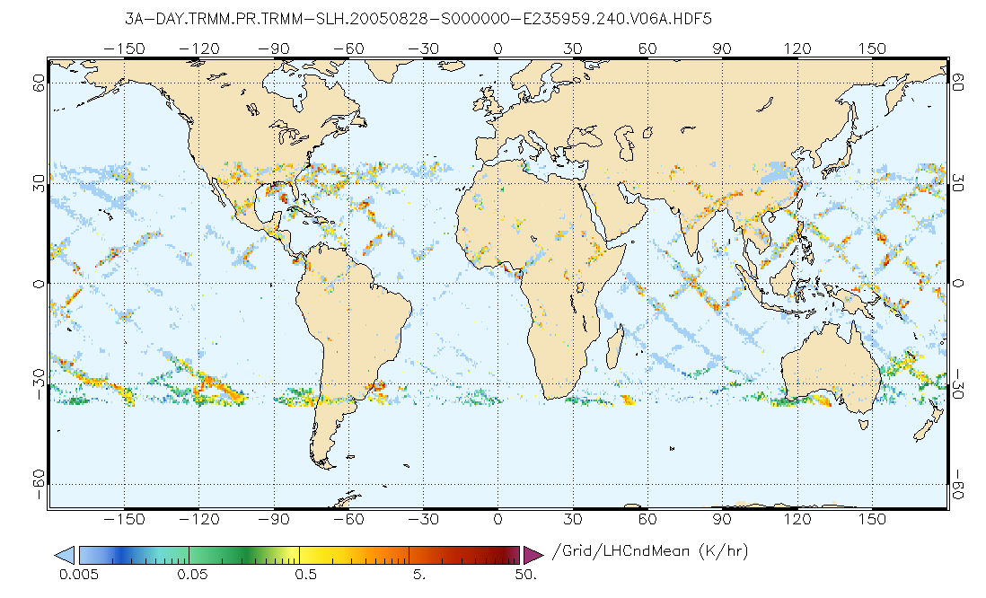
GPM PR on TRMM Spectral Latent Heating Profiles L3 1 Day 0.5x0.5 degree V07 (GPM_3HSLH_TRMM_DAY) at GES DISC
National Aeronautics and Space Administration —
This a new (GPM-formated) TRMM product. There is no equivalent in the old TRMM suite of products.Version 07 is the current version of the data set. Older versions... -
Federal
NACP Regional: National Greenhouse Gas Inventories and Aggregated Gridded Model Data
National Aeronautics and Space Administration —
This data set provides two products that were derived from the recently published North American Carbon Program (NACP) Regional Synthesis 1-degree terrestrial... -
Federal
LUH1: Harmonized Global Land Use for Years 1500-2100, V1
National Aeronautics and Space Administration —
These data represent fractional land use and land cover patterns annually for the years 1500 - 2100 for the globe at 0.5-degree (~50-km) spatial resolution. Land use... -
Federal
MODIS/Terra+Aqua Direct Broadcast Burned Area Monthly L3 Global 500m SIN Grid V006
National Aeronautics and Space Administration —
The MCD64A1 Version 6 data product was decommissioned on July 31, 2023. Users are encouraged to use the MCD64A1... -
Federal
MODIS/Terra+Aqua Direct Broadcast Burned Area Monthly L3 Global 500m SIN Grid V061
National Aeronautics and Space Administration —
The Terra and Aqua combined MCD64A1 Version 6.1 Burned Area data product is a monthly, global gridded 500 meter (m) product containing per-pixel burned-area and... -
Federal
Global Distribution of Plant-Extractable Water Capacity of Soil (Dunne)
National Aeronautics and Space Administration —
Plant-extractable water capacity of soil is the amount of water that can be extracted from the soil to fulfill evapotranspiration demands. It is often assumed to be... -
Federal
Aqua/AIRS L3 Daily Standard Physical Retrieval (AIRS+AMSU) 1 degree x 1 degree V7.0 at GES DISC
National Aeronautics and Space Administration —
The Atmospheric Infrared Sounder (AIRS) is a grating spectrometer (R = 1200) aboard the second Earth Observing System (EOS) polar-orbiting platform, EOS Aqua. In... -
Federal
RapidScat Level 2B Climate Ocean Wind Vectors in 12.5km Footprints Version 2.0
National Aeronautics and Space Administration —
This dataset contains the RapidScat Level 2B 12.5km Version 2.0 Climate quality ocean surface wind vectors. The Level 2B wind vectors are binned on a 12.5 km Wind... -
Federal
Regridded Harmonized World Soil Database v1.2
National Aeronautics and Space Administration —
This data set describes select global soil parameters from the Harmonized World Soil Database (HWSD) v1.2, including additional calculated parameters such as area... -
Federal
GPM IMERG Late Precipitation L3 1 day 0.1 degree x 0.1 degree V07 (GPM_3IMERGDL) at GES DISC
National Aeronautics and Space Administration —
Version 07 is the current version of the data set. Older versions will no longer be available and have been superseded by Version 07.The Integrated Multi-satellitE... -
Federal
ABI G16 Deep Blue L3 Daily Aerosol Data, 1 x 1 degree grid
National Aeronautics and Space Administration —
The ABI G16 Deep Blue L3 Daily Aerosol Data, 1 x 1 degree grid product, short-name AERDB_D3_ABI_G16, derived from the L2 (AERDB_L2_ABI_G16) input data, each D3... -
Federal
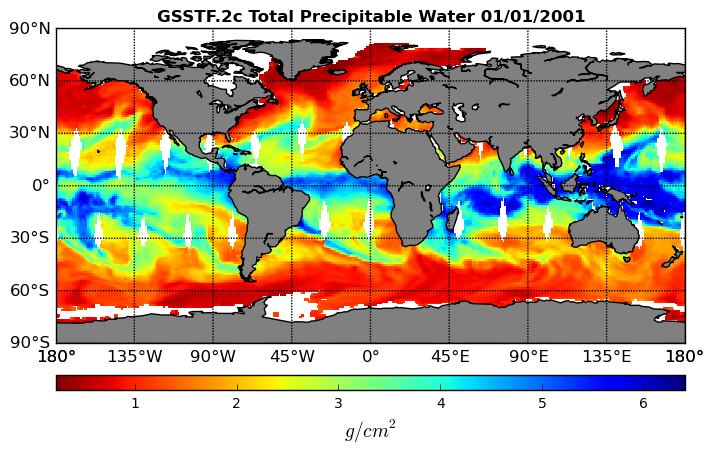
Goddard Satellite-Based Surface Turbulent Fluxes, 1x1 deg Monthly Climatology, Set1 and NCEP V2c (GSSTFMC) at GES DISC
National Aeronautics and Space Administration —
These data are the Goddard Satellite-based Surface Turbulent Fluxes Version-2c Dataset recently produced through a MEaSURES funded project led by Dr. Chung-Lin Shie... -
Federal
Goddard Satellite-Based Surface Turbulent Fluxes, 0.25 x 0.25 deg, Daily Grid V3 (GSSTF) at GES DISC
National Aeronautics and Space Administration —
These data are the Goddard Satellite-based Surface Turbulent Fluxes Version-3 (GSSTF3) Dataset recently produced through a MEaSUREs funded project led by Dr. Chung-... -
Federal
MODIS/Terra Land Surface Temperature/3-Band Emissivity Daily L3 Global 1km SIN Grid Day V061
National Aeronautics and Space Administration —
A suite of Moderate Resolution Imaging Spectroradiometer (MODIS) Land Surface Temperature and Emissivity (LST&E) products are available in Collection 6.1. The... -
Federal
MODIS/Aqua Land Surface Temperature/3-Band Emissivity Daily L3 Global 1km SIN Grid Night V061
National Aeronautics and Space Administration —
A suite of Moderate Resolution Imaging Spectroradiometer (MODIS) Land Surface Temperature and Emissivity (LST&E) products are available in Collection 6.1. The... -
Federal
CYGNSS Level 3 Science Data Record Version 3.2
National Aeronautics and Space Administration —
This dataset contains the version 3.2 CYGNSS level 3 science data record which provides the average wind speed and mean square slope (MSS) on a 0.2x0.2 degree... -
Federal
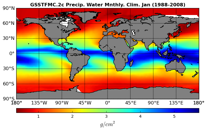
Goddard Satellite-Based Surface Turbulent Fluxes Climatology, 0.25 x 0.25 deg, Monthly Grid V3 (GSSTFMC) at GES DISC
National Aeronautics and Space Administration —
These data are the Goddard Satellite-based Surface Turbulent Fluxes Version-3 Dataset recently produced through a MEaSUREs funded project led by Dr. Chung-Lin Shie...

Official websites use .gov
A
.gov website belongs to an official government
organization in the United States.
Secure .gov websites use HTTPS
A
lock (
) or https:// means you’ve safely connected to
the .gov website. Share sensitive information only on official,
secure websites.