
-
Federal
Resilient Africa Network: The State of Ghanaian Resilience II
US Agency for International Development —
The study set out to understand the extent to which households and systems are affected by shocks and stressors related to rapid urbanization, climate change and food... -
Federal
SAFARI 2000 Emissions Estimates, MODIS Burned Area Product, Dry Season 2000
National Aeronautics and Space Administration —
The recently generated MODIS burned area product over southern Africa for the month of September 2000 was used to calculate regional biomass burning emissions from... -
Federal
SAFARI 2000 C-130 Aerosol and Meteorological Data, Dry Season 2000
National Aeronautics and Space Administration —
The Met Office C-130 research aircraft was based at Windhoek, Namibia between September 5-16, 2000, where it conducted a series of flights over Namibia as part of the... -
Federal
SAFARI 2000 MODIS 500-m Burned Area Products, Southern Africa, Dry Season 2000
National Aeronautics and Space Administration —
The SAFARI 2000 project was selected as the first regional test for a prototype regional 500 m MODIS burned area product. The MODIS burned area product maps the 500 m... -
Federal
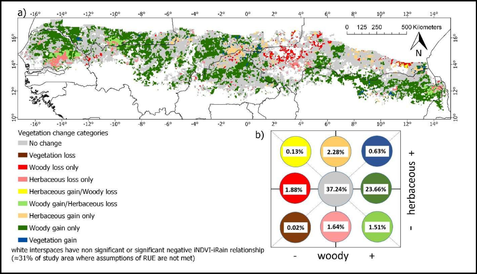
Woody and Herbaceous Vegetation Change across the Savannas of West Africa, 1982-2013
National Aeronautics and Space Administration —
The WAVeTrends dataset is a 0.05 degree (5.55 km) vegetation change product, spanning the West African Sudano-Sahel region. It provides pixel-wise information on... -
Federal
Characteristics of African Savanna Biomes for Determining Woody Cover
National Aeronautics and Space Administration —
This data set includes the soil and vegetation characteristics, herbivore estimates, and precipitation measurement data for the 854 sites described and analyzed in... -
Federal
SAFARI 2000 Solar Spectral Flux Radiometer Data, Southern Africa, Dry Season 2000
National Aeronautics and Space Administration —
The Solar Spectral Flux Radiometer (SSFR) was deployed on the University of Washington CV-580 during the dry season component of the Southern African Regional Science... -
Federal
SAFARI 2000 NBI Vegetation Map of the Savannas of Southern Africa
National Aeronautics and Space Administration —
The National Botanical Institute (NBI) has mapped woody plant species distribution to provide estimates of individual species contribution to peak leaf area index for... -
Federal
SAFARI 2000 SeaWiFS Images for the Southern African Region, 1999-2001
National Aeronautics and Space Administration —
This data set contains Sea-viewing Wide Field-of-view Sensor (SeaWiFS) imagery for the southern African region. These images are Level-1a swaths of the southern... -
Federal
SAFARI 2000 Freshwater Wetlands, 1-Deg (Stillwell-Soller et al.)
National Aeronautics and Space Administration —
The data set consists of a southern Africa subset of the Global Distribution of Freshwater Wetlands database 1-degree data and are available in ASCII GRID and binary... -
Federal
SAFARI 2000 Estimated BVOC Emissions for Southern African Land Cover Types
National Aeronautics and Space Administration —
Improved vegetation distribution and emission data for Africa south of the equator were developed for the Southern African Regional Science Initiative (SAFARI 2000)... -
Federal
SAFARI 2000 Fire Emission Data, Dry Season 2000
National Aeronautics and Space Administration —
As part of the Southern Africa Regional Science Initiative (SAFARI 2000), the University of Montana participated in both ground-based and airborne campaigns during... -
Federal
SAFARI 2000 AERONET Ground-based Aerosol Data, Dry Season 2000
National Aeronautics and Space Administration —
AERONET (AErosol RObotic NETwork) is an optical ground-based aerosol monitoring network and data archive system. AERONET measurements of the column-integrated aerosol... -
Federal
SAFARI 2000 BRDF Measurements at Sua Pan and Skukuza, Dry Season 2000
National Aeronautics and Space Administration —
The Jet Propulsion Laboratory's (JPL) Portable Apparatus for Rapid Acquisition of Bidirectional Observation of the Land and Atmosphere (PARABOLA), version III,... -
Federal
SAFARI 2000 Micro-Pulse Lidar Cloud and Aerosol Data, Dry Season 2000
National Aeronautics and Space Administration —
Two Micro-Pulse Lidar (MPL) systems were deployed to Africa for the SAFARI 2000 experiment. One MPL was setup in Mongu, Zambia and the other was setup in Skukuza,... -
Federal
SAFARI 2000 Upper Air Meteorological Profiles, South Africa, Dry Season 2000
National Aeronautics and Space Administration —
The University of Wyoming has a series of balloonborne radiosonde measurements from all around the world, from the surface to 30 km. This data set contains upper air... -
Federal
SAFARI 2000 MODIS MOD04_L2 Aerosol Data, GRANT Format, for Southern Africa
National Aeronautics and Space Administration —
The subset of the Moderate Resolution Imaging Spectroradiometer (MODIS) MOD04_L2 aerosol product provided in this data set represents the swaths that coincide with... -
Federal
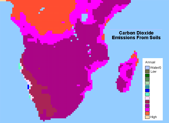
SAFARI 2000 Monthly and Annual CO2 Emissions from Soil, 0.5 Degree Grid
National Aeronautics and Space Administration —
The data set provides estimated monthly and annual soil CO2 emissions for southern Africa (the SAFARI 2000 project region). The calculated emissions are from the... -
Federal
HTAP_v2.2: a mosaic of regional and global emission gridmaps for 2008 and 2010 to study hemispheric transport of air pollution.
U.S. Environmental Protection Agency —
This dataset provides the EPA portion of a compilation of different regional gridded inventories, including data from Environment Canada for Canada, the European...

Official websites use .gov
A
.gov website belongs to an official government
organization in the United States.
Secure .gov websites use HTTPS
A
lock (
) or https:// means you’ve safely connected to
the .gov website. Share sensitive information only on official,
secure websites.