
-
Federal
AVIRIS-NG L2 Surface Reflectance, Facility Instrument Collection, V1
National Aeronautics and Space Administration —
This dataset contains Level 2 (L2) orthocorrected reflectance from the Airborne Visible / Infrared Imaging Spectrometer-Next Generation (AVIRIS-NG) instrument. This... -
Federal
Global Pesticide Grids (PEST-CHEMGRIDS), Version 1.01
National Aeronautics and Space Administration —
The Global Pesticide Grids (PEST-CHEMGRIDS), Version 1.01 data set contains 20 of the most-used pesticide active ingredients on 6 dominant crops and 4 aggregated crop... -
Federal
SWOT Level 2 Radiometer Brightness Temperatures and Troposphere Operational Data Product
National Aeronautics and Space Administration —
The SWOT Level 2 Radiometer Brightness Temperatures and Troposphere Operational Geophysical Data Record (OGDR) Version 1.0 dataset produced by the Surface Water and... -
Federal
SWOT Level 2 Radiometer Brightness Temperatures and Troposphere Operational Data Product Version 1.0
National Aeronautics and Space Administration —
The SWOT Level 2 Radiometer Brightness Temperatures and Troposphere Operational Geophysical Data Record (OGDR) Version 1.0 dataset produced by the Surface Water and... -
Federal
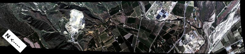
MASTER: Geological Earth Mapping Experiment (GEMx), California-Arizona, Summer 2023
National Aeronautics and Space Administration —
This dataset includes Level 1B (L1B) and Level 2 (L2) data products from the MODIS/ASTER Airborne Simulator (MASTER) instrument. The spectral data were collected... -
Federal
SHIFT: AVIRIS-NG Full-Resolution True Color Images
National Aeronautics and Space Administration —
This dataset holds full-resolution 3-band (true color) imagery acquired by NASA's Airborne Visible / Infrared Imaging Spectrometer-Next Generation (AVIRIS-NG)... -
Federal
SWOT Level 2 Radiometer Brightness Temperatures and Troposphere Operational Data Product Version D
National Aeronautics and Space Administration —
The SWOT Level 2 Radiometer Brightness Temperatures and Troposphere Operational Geophysical Data Record (OGDR) Version D dataset produced by the Surface Water and... -
Federal
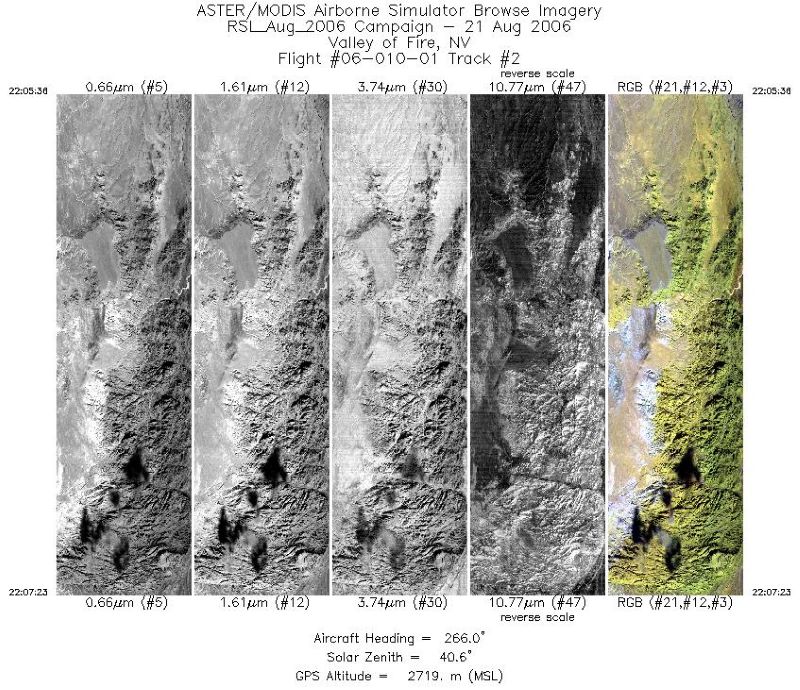
MASTER: Airborne Science, California-Nevada, August, 2004
National Aeronautics and Space Administration —
This dataset includes Level 1B (L1B) data products from the MODIS/ASTER Airborne Simulator (MASTER) instrument. The spectral data were collected during one flight... -
Federal
SWOT Level 2 Radiometer Brightness Temperatures and Troposphere Interim Data Product Version D
National Aeronautics and Space Administration —
The SWOT Level 2 Radiometer Brightness Temperatures and Troposphere Interim Geophysical Data Record (IGDR) Version D dataset produced by the Surface Water and Ocean... -
Federal
SSGF Mineral Major Elements and Lithium Concentration
Department of Energy —
Presented are major element and lithium concentrations of minerals from the Salton Sea Geothermal Field (SSGF), located in the Imperial Valley, California. With a... -
Federal
SWOT Level 2 Radiometer Brightness Temperatures and Troposphere Operational Data Product, Version 2.0
National Aeronautics and Space Administration —
The SWOT Level 2 Radiometer Brightness Temperatures and Troposphere Operational Geophysical Data Record (OGDR) Version 1.0 dataset produced by the Surface Water and... -
Federal
Geothermal Data Gap Analysis Over the Western US
Department of Energy —
NREL, as part of the Play Fairway Analysis Retrospective, compiled and mapped publicly available geologic and geophysical data in relation to the 2008 USGS geothermal... -
Federal
SWOT Level 2 Radiometer Brightness Temperatures and Troposphere Interim Data Product Version 1.0
National Aeronautics and Space Administration —
The SWOT Level 2 Radiometer Brightness Temperatures and Troposphere Interim Geophysical Data Record (IGDR) Version 1.0 dataset produced by the Surface Water and Ocean... -
Federal
SHIFT: AVIRIS-NG L1A Unrectified Radiance
National Aeronautics and Space Administration —
This dataset contains Level 1A (L1A) unrectified surface radiance image files as well as files of observational geometry and illumination parameters and supporting... -
Federal
HLS Sentinel-2 Multi-spectral Instrument Surface Reflectance Daily Global 30m v2.0
National Aeronautics and Space Administration —
The Harmonized Landsat Sentinel-2 (HLS) project provides consistent surface reflectance data from the Operational Land Imager (OLI) aboard the joint NASA/USGS Landsat... -
Federal
MASTER: Airborne Science, Southwest US, August 2006
National Aeronautics and Space Administration —
This dataset includes Level 1B (L1B) data products from the MODIS/ASTER Airborne Simulator (MASTER) instrument. The spectral data were collected during 18 flights... -
Federal
Fallon FORGE: Seismic Reflection Profiles
Department of Energy —
Newly reprocessed Naval Air Station Fallon (1994) seismic lines: pre-stack depth migrations, with interpretations to support the Fallon FORGE (Phase 2B) 3D Geologic... -
Federal
MASTER: Geological Earth Mapping Experiment (GEMx), Spring 2024
National Aeronautics and Space Administration —
This dataset includes Level 1B (L1B) data products from the MODIS/ASTER Airborne Simulator (MASTER) instrument. The spectral data were collected during 26 flights...

Official websites use .gov
A
.gov website belongs to an official government
organization in the United States.
Secure .gov websites use HTTPS
A
lock (
) or https:// means you’ve safely connected to
the .gov website. Share sensitive information only on official,
secure websites.