
-
Federal
NOAA Environmental Sensitivity Index (ESI) maps and geographic information systems data from 1900 to 2009
National Oceanic and Atmospheric Administration, Department of Commerce —
This collection comprises the Environmental Sensitivity Index (ESI) data for various regions in U.S. coastal waters. ESI data characterize estuarine environments and... -
Federal
NOAA/WDS Paleoclimatology - Global Lake-Level Variations from 18,000 to 0 Years Ago: A Paleoclimatic Analysis
National Oceanic and Atmospheric Administration, Department of Commerce —
This archived Paleoclimatology Study is available from the NOAA National Centers for Environmental Information (NCEI), under the World Data Service (WDS) for... -
Federal
Global Historical Climatology Network - Daily (GHCN-Daily), Version 2 (Version Superseded)
National Oceanic and Atmospheric Administration, Department of Commerce —
Please note, this dataset has been superseded by a newer version (see below). Users should not use this version except in rare cases (e.g., when reproducing previous... -
Federal
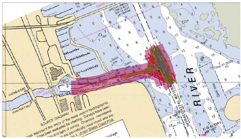
Near real-time environmental monitoring in support of Port Everglades dredging projects, Fort Lauderdale, FL (NCEI Accession 0303581)
National Oceanic and Atmospheric Administration, Department of Commerce —
The system records in-situ water quality data at a depth of 26 feet, including temperature, salinity, turbidity, backscatter, PAR (Photosynthetically Active... -
Federal
Indian River Lagoon - Fort Pierce (IRL-FP)
National Oceanic and Atmospheric Administration, Department of Commerce —
Timeseries data from 'Indian River Lagoon - Fort Pierce (IRL-FP)' (indian-river-lagoon-fort-pierce-) -
Federal
East Florida, 1993 - 1995 Environmental Sensitivity Index Map
National Oceanic and Atmospheric Administration, Department of Commerce —
Environmental Sensitivity Index (ESI) maps are an integral component in oil-spill contingency planning and assessment. They serve as a source of information in the... -
Federal
F00634: NOS Hydrographic Survey , 2013-06-04
National Oceanic and Atmospheric Administration, Department of Commerce —
The National Oceanic and Atmospheric Administration (NOAA) has the statutory mandate to collect hydrographic data in support of nautical chart compilation for safe... -
Federal
B00008: NOS Hydrographic Survey , 1984-11-09
National Oceanic and Atmospheric Administration, Department of Commerce —
The National Oceanic and Atmospheric Administration (NOAA) has the statutory mandate to collect hydrographic data in support of nautical chart compilation for safe... -
Federal
F00869: NOS Hydrographic Survey , 2022-10-04
National Oceanic and Atmospheric Administration, Department of Commerce —
The National Oceanic and Atmospheric Administration (NOAA) has the statutory mandate to collect hydrographic data in support of nautical chart compilation for safe... -
Federal
Calculations of the Total Number of Electrons Along a Ray Path Extending from the Transmitter to the Receiver
National Oceanic and Atmospheric Administration, Department of Commerce —
Ionospheric Total Electron Content (TEC) is the total number of electrons in a column of unit cross section extending from the transmitter to the receiver. TEC is... -
Federal
Physical, meteorological, and biological data collected from non-federal stations assembled by the Northwest Association of Networked Ocean Observing Systems (NANOOS)
National Oceanic and Atmospheric Administration, Department of Commerce —
This dataset contains physical, meteorological and geochemical data, collected at moorings located in Puget Sound, WA and along the Washington and Oregon coasts. The... -
Federal
B00006: NOS Hydrographic Survey , 1984-11-05
National Oceanic and Atmospheric Administration, Department of Commerce —
The National Oceanic and Atmospheric Administration (NOAA) has the statutory mandate to collect hydrographic data in support of nautical chart compilation for safe... -
Federal
HARE INDIAN RIVER NEAR FORT GOOD HOPE
National Oceanic and Atmospheric Administration, Department of Commerce —
Timeseries data from 'HARE INDIAN RIVER NEAR FORT GOOD HOPE' (ca_hydro_10LD004) -
Federal
National Status and Trends, Benthic Surveillance Project Sites, 1984-1992, National Centers for Coastal Ocean Science
National Oceanic and Atmospheric Administration, Department of Commerce —
This data set reports information regarding the nominal sampling locations for the National Status and Trends Benthic Surveillance Project sites. One record is... -
Federal
National Coral Reef Monitoring Program: Water temperature data from subsurface temperature recorders (STRs) deployed at coral reef sites along the Florida Reef Tract
National Oceanic and Atmospheric Administration, Department of Commerce —
This collection contains water temperature data collected using subsurface temperature recorders (STRs) that aid in the monitoring of seawater temperature variability... -
Federal
CO-OPS station 8725520: FORT MYERS, CALOOSAHATCHEE RIVER 1-minute Raw Tsunami Water Level Data
National Oceanic and Atmospheric Administration, Department of Commerce —
CO-OPS has been involved with tsunami warning and mitigation since the Coast and Geodetic Survey started the Tsunami Warning System in 1948 to provide warnings to the... -
Federal
NOAA/WDS Paleoclimatology - Asmerom Y.,et al. 2010. Fort Stanton Cave, New Mexico 55-11kY Speleothem d18O Data.
National Oceanic and Atmospheric Administration, Department of Commerce —
This archived Paleoclimatology Study is available from the NOAA National Centers for Environmental Information (NCEI), under the World Data Service (WDS) for... -
Federal
H11733: NOS Hydrographic Survey , Northern California Coast, California, 2007-04-01
National Oceanic and Atmospheric Administration, Department of Commerce —
The National Oceanic and Atmospheric Administration (NOAA) has the statutory mandate to collect hydrographic data in support of nautical chart compilation for safe... -
Federal
Multibeam collection for RB0703: Multibeam data collected aboard NOAA Ship RONALD H. BROWN (R104) from 02-May-07 to 29-May-07, Bridgetown, Barbados to Fort Lauderdale, Florida
National Oceanic and Atmospheric Administration, Department of Commerce —
This data set is part of a larger set of data called the Multibeam Bathymetry Database (MBBDB) where other similar data can be found -
Federal
Fort Mcpherson
National Oceanic and Atmospheric Administration, Department of Commerce —
Timeseries data from 'Fort Mcpherson' (boem_ahmd_fort_mcpherson)

Official websites use .gov
A
.gov website belongs to an official government
organization in the United States.
Secure .gov websites use HTTPS
A
lock (
) or https:// means you’ve safely connected to
the .gov website. Share sensitive information only on official,
secure websites.
.jpg)