
-
County
Fire Protection District and Municipal Fire Departments
Lake County, Illinois —
Download In State Plane Projection Here. These boundaries represent either a Fire Protection Taxing District or a municipal fire department and are based on legal... -
State
Recent Large Fire Perimeters (GT 5000 acres)
State of California —
The California Department of Forestry and Fire Protection's Fire and Resource Assessment Program (FRAP) annually maintains and distributes an historical wildland fire... -
City
Louisville Metro KY - Animal Services Activity Log
Louisville Metro Government —
Animal Services Provides for the care and control of animals in the Louisville Metro area, including pet licensing and pet adoption.Data Dictionary:case number... -
State
California Fire Perimeters (all)
State of California —
The California Department of Forestry and Fire Protection's Fire and Resource Assessment Program (FRAP) annually maintains and distributes an historical wildland fire... -
State
Fire Hazard Severity Zones, in SRA Effective April 1, 2024 with LRA Recommended 2007-2011
State of California —
Pursuant to Public Resource Code 4202, The State Fire Marshal shall classify lands within State Responsibility Areas into fire hazard severity zones. Each zone shall... -
Federal
BLM Natl AIM TerrADat Hub
Department of the Interior —
This feature class includes monitoring data collected nationally to understand the status, condition, and trend of resources on BLM lands. It focuses on the BLM... -
Federal
BLM OR Fire Point Hub
Department of the Interior —
FIRE_POINT: This dataset represents points of origins of BLM fires that occur naturally (e.g., lightning) or by humans accidentally (e.g., escaped campfire) or... -
Federal
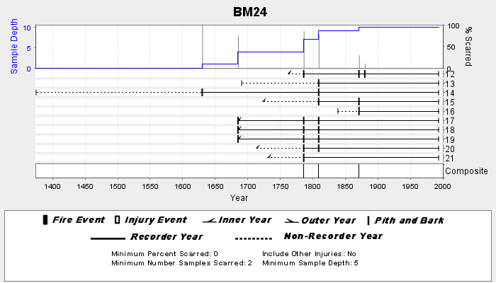
NOAA/WDS Paleoclimatology - Veblen fire data from BM24 - IMPD USBM-024
National Oceanic and Atmospheric Administration, Department of Commerce —
This archived Paleoclimatology Study is available from the NOAA National Centers for Environmental Information (NCEI), under the World Data Service (WDS) for... -
Federal
NOAA/WDS Paleoclimatology - Smith - Van Bibber Creek Recollection - PIPO - ITRDB CO698
National Oceanic and Atmospheric Administration, Department of Commerce —
This archived Paleoclimatology Study is available from the NOAA National Centers for Environmental Information (NCEI), under the World Data Service (WDS) for... -
Federal
NOAA/WDS Paleoclimatology - Swetnam fire data from Animas Peak - IMPD USANP002
National Oceanic and Atmospheric Administration, Department of Commerce —
This archived Paleoclimatology Study is available from the NOAA National Centers for Environmental Information (NCEI), under the World Data Service (WDS) for... -
City
Louisville Metro KY - Animal Services Citation
Louisville Metro Government —
Animal Services Provides for the care and control of animals in the Louisville Metro area, including pet licensing and pet adoption. Data Dictionary: violation... -
City
Louisville Metro KY - Fire Incident
Louisville Metro Government —
The Louisville Division of Fire, commonly known as the Louisville Fire Department or Louisville Fire & Rescue (abbreviated LFD or LFR), is the sole fire... -
Federal
NOAA/WDS Paleoclimatology - Guiterman fire data from Luna Lake - IMPD USLLK001
National Oceanic and Atmospheric Administration, Department of Commerce —
This archived Paleoclimatology Study is available from the NOAA National Centers for Environmental Information (NCEI), under the World Data Service (WDS) for... -
Federal
NOAA/WDS Paleoclimatology - Stambaugh fire data from Homer Mountain - IMPD USHOM001
National Oceanic and Atmospheric Administration, Department of Commerce —
This archived Paleoclimatology Study is available from the NOAA National Centers for Environmental Information (NCEI), under the World Data Service (WDS) for... -
Federal
NOAA/WDS Paleoclimatology - Mundo fire data from Ea. Canigó W, Patagonia - IMPD ARCAN002
National Oceanic and Atmospheric Administration, Department of Commerce —
This archived Paleoclimatology Study is available from the NOAA National Centers for Environmental Information (NCEI), under the World Data Service (WDS) for... -
Federal
NOAA/WDS Paleoclimatology - Everett fire data from Frosty Aspect Polygon 5 - IMPD USFRS005
National Oceanic and Atmospheric Administration, Department of Commerce —
This archived Paleoclimatology Study is available from the NOAA National Centers for Environmental Information (NCEI), under the World Data Service (WDS) for... -
Federal
BLM OR Exclosure Protection Treatments Polygon Hub
Department of the Interior —
PROT_POLY: This dataset represents completed treatments involving fenced exclosures or protective devices on trees or soil surfaces on BLM managed lands in the states... -
Federal
BLM MT SMA Surface Ownership Polygon
Department of the Interior —
Surface Management Agency: The Surface Management Agency (SMA) Geographic Information System (GIS) dataset depicts Federal land for the State of Montana, and... -
Federal
NOAA/WDS Paleoclimatology - Swetnam fire data from Sierra Ajos - IMPD USMDB002
National Oceanic and Atmospheric Administration, Department of Commerce —
This archived Paleoclimatology Study is available from the NOAA National Centers for Environmental Information (NCEI), under the World Data Service (WDS) for... -
Federal
NOAA/WDS Paleoclimatology - Castor and Round Lake, Washington Isotope and Charcoal Data over the past 1,200 Years
National Oceanic and Atmospheric Administration, Department of Commerce —
This archived Paleoclimatology Study is available from the NOAA National Centers for Environmental Information (NCEI), under the World Data Service (WDS) for...

Official websites use .gov
A
.gov website belongs to an official government
organization in the United States.
Secure .gov websites use HTTPS
A
lock (
) or https:// means you’ve safely connected to
the .gov website. Share sensitive information only on official,
secure websites.