
-
Federal
Global Population Density Grid Time Series Estimates
National Aeronautics and Space Administration —
The Global Population Density Grid Time Series Estimates provide a back-cast time series of population density grids based on the year 2000 population grid from... -
City
Aerial Photography (imagery)
City of Philadelphia —
Data includes aerial photography of the City of Philadelphia. -
Federal
Data and Code from: Smart vision-based monitoring system for AI-driven moth population estimation using camera-equipped trap imaging
Department of Agriculture —
Real-time, image-based monitoring for stored product insect pests could increase timely treatments and protection for postharvest products throughout the supply... -
Federal
NASA Shuttle Radar Topography Mission Swath Image Data V003
National Aeronautics and Space Administration —
The Land Processes Distributed Active Archive Center (LP DAAC) is responsible for the archive and distribution of NASA Making Earth System Data Records for Use in... -
Federal
JPSS1 CrIS-VIIRS 750-m Matchup Indexes V1 (J1_CrIS_VIIRS750m_IND) at GES_DISC
National Aeronautics and Space Administration —
This dataset includes JPSS-1 VIIRS-CrIS collocation index product, within the framework of the Multidecadal Satellite Record of Water Vapor, Temperature, and Clouds... -
Federal
Headwall Hyperspectral Reflectance LTER Cedar Creek Minnesota Multi-Year 1 mm
National Aeronautics and Space Administration —
The Headwall Hyperspectral Reflectance data are for the Long-Term Ecological Research (LTER) at Cedar Creek Ecosystem Science Reserve (CCESR), Minnesota... -
Federal
Data from: Avian Sentinels Neural Nest: AI-Powered Bird Monitoring System for Real-Time Detection and Species Identification
Department of Agriculture —
Traditional bird deterrent methods, such as scarecrows, loud noise emitters, and netting, can become less effective over time due to bird habituation. This study... -
Federal
Integrated Multi-Mission Ocean Altimeter Data for Climate Research complete time series Version 5.2
National Aeronautics and Space Administration —
The Integrated Multi-Mission Ocean Altimeter Sea Surface Height (SSH) Version 5.2 dataset provides level 2 along track sea surface height anomalies (SSHA) from the... -
Federal
Daily and Annual PM2.5, O3, and NO2 Concentrations at ZIP Codes for the Contiguous U.S., 2000-2016, v1.0
National Aeronautics and Space Administration —
The Daily and Annual PM2.5, O3, and NO2 Concentrations at ZIP Codes for the Contiguous U.S., 2000-2016, v1.0 data set contains daily and annual concentration... -
Federal
Compendium of Environmental Sustainability Indicator Collections: 2004 Environmental Vulnerability Index (EVI)
National Aeronautics and Space Administration —
The 2004 Environmental Vulnerability Index (EVI) portion of the Compendium of Environmental Sustainability Indicator Collections contains 111 variables for 235... -
Federal
NCCN Forest Vegetation Monitoring Data Package, 2005-2018
Department of the Interior —
This data package contains North Coast and Cascades Network (NCCN) Inventory and Monitoring Program forest vegetation tabular data collected during 2005-2018 in Mount... -
Federal
UNH TDP - Concurrent Measurements of Inflow, Power Performance, and Loads for a Grid-Synchronized Vertical Axis Cross-Flow Turbine Operating in a Tidal Estuary
Department of Energy —
This data was collected between October 12 and December 15 of 2021 at the University of New Hampshire (UNH) and Atlantic Marine Energy Center (AMEC) turbine... -
Federal
GHRSST L2P NOAA/ACSPO GOES-18/ABI America Region Sea Surface Temperature v2.90 dataset
National Aeronautics and Space Administration —
The G18-ABI-L2P-ACSPO-v2.90 dataset produced by the NOAA Advanced Clear Sky Processor for Ocean (ACSPO) system is used to derive Sea Surface Skin Temperature (SST)... -
Federal
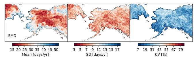
ABoVE: Passive Microwave-derived Annual Snow Melt Duration Date Maps, 1988-2018
National Aeronautics and Space Administration —
This dataset provides the annual period of snowpack melting (i.e., snow melt duration, SMD) across northwest Canada; Alaska, U.S.; and parts of far eastern Russia at... -
Federal
Aqua AIRS-MODIS 1-km Matchup Indexes V1 (Aqua_AIRS_MODIS1km_IND) at GES_DISC
National Aeronautics and Space Administration —
This dataset includes Aqua AIRS to MODIS 1-km collocation index product, within the framework of the Multidecadal Satellite Record of Water Vapor, Temperature, and... -
Federal
RSS CCMP 6-Hourly 10 Meter Surface Winds Level 4 Version 3.1
National Aeronautics and Space Administration —
This data set contains a 6-hourly, 0.25 degree resolution, near-global gridded analysis of ocean surface vector winds from the Cross-Calibrated Multi-Platform (CCMP)... -
Federal
MEaSUREs Vegetation Continuous Fields (VCF) Yearly Global 0.05 Deg V001
National Aeronautics and Space Administration —
The NASA Making Earth System Data Records for Use in Research Environments (- BIN
- BIN
- HTML
- BIN
- PDF
- PDF
- 2 more in dataset
FederalMetop-A ASCAT Inter-Calibrated ESDR Level 2 Observed and Modeled Spatial Derivatives of Surface Wind and Wind Stress Version 1.0
National Aeronautics and Space Administration —
This dataset contains the curl and divergence of ocean surface equivalent neutral wind and wind stress, derived from satellite-based scatterometer observations (the...FederalIPCC Socio-Economic Baseline Dataset
National Aeronautics and Space Administration —
The Intergovernmental Panel on Climate Change (IPCC) Socio-Economic Baseline Dataset consists of population, human development, economic, water resources, land cover,...FederalGenome analysis of the ubiquitous boxwood pathogen Pseudonectria foliicola: A small fungal genome with an increased cohort of genes associated with loss of virulence
Department of Agriculture —
Boxwood plants are affected by many different diseases caused by fungi. Some boxwood diseases are deadly and quickly kill the infected plants, but with others, the...136 datasets found for "Environment"

Official websites use .gov
A
.gov website belongs to an official government
organization in the United States.
Secure .gov websites use HTTPS
A
lock (
) or https:// means you’ve safely connected to
the .gov website. Share sensitive information only on official,
secure websites.