
-
Federal
ECOSTRESS Evapotranspiration dis-ALEXI USDA Daily L3 Global 30m V001
National Aeronautics and Space Administration —
The ECOsystem Spaceborne Thermal Radiometer Experiment on Space Station (ECOSTRESS) mission measures the temperature of plants to better understand how much water... -
Federal
Groundwater and Soil Moisture Conditions from GRACE and GRACE-FO Data Assimilation L4 7-days 0.25 x 0.25 degree Global V3.0 (GRACEDADM_CLSM025GL_7D) at GES DISC
National Aeronautics and Space Administration —
Scientists at NASA Goddard Space Flight Center generate groundwater and soil moisture drought indicators each week. They are based on terrestrial water storage... -
Federal
CMS: Forest Carbon Stocks, Emissions, and Net Flux for the Conterminous US: 2005-2010
National Aeronautics and Space Administration —
This data set provides maps of estimated carbon in forests of the 48 continental states of the US for the years 2005-2010. Carbon (termed committed carbon) stocks... -
Federal
NACP: Forest Carbon Stocks, Fluxes and Productivity Estimates, Western USA, 1979-2099
National Aeronautics and Space Administration —
This dataset contains annual estimates of carbon stocks, fluxes, and productivity over forested land in 11 states of the western USA (Arizona, California, Colorado,... -
Federal
ECOSTRESS Evapotranspiration dis-ALEXI Daily L3 CONUS 70 m V001
National Aeronautics and Space Administration —
The ECOsystem Spaceborne Thermal Radiometer Experiment on Space Station (ECOSTRESS) mission measures the temperature of plants to better understand how much water... -
Federal
Global High-Resolution Estimates of SIF from Fused SCIAMACHY and GOME-2, V2
National Aeronautics and Space Administration —
This dataset provides global solar-induced chlorophyll fluorescence (SIF) estimates at a 0.05-degree resolution (approximately 5 km at the equator) for each month... -
Federal
MERRA-2 statM_2d_pct_Nx: 2d, Single-Level, Monthly Percentiles V1 (M2SMNXPCT) at GES DISC
National Aeronautics and Space Administration —
M2SMNXPCT (or statM_2d_pct_Nx) is a 2-dimensional monthly data collection for percentile statistics derived from monthly Modern-Era Retrospective analysis for... -
Federal
MERRA-2 statM_2d_pct_Nx: 2d, Single-Level, Monthly Percentiles based on 1991-2020 V2 (M2SMNXPCT) at GES DISC
National Aeronautics and Space Administration —
M2SMNXPCT (or statM_2d_pct_Nx) is a 2-dimensional monthly data collection for percentile statistics derived from monthly Modern-Era Retrospective analysis for... -
Federal
CI Asteroid Regolith as an In Situ Plant Growth Medium for Space Crop Production
National Aeronautics and Space Administration —
Human expansion into the solar system is currently at the forefront of space research. For our astronauts to survive, they will need to be fed a healthy and... -
Federal
NPP Cropland: Gridded Estimates For the Central USA, 1982-1996, R1
National Aeronautics and Space Administration —
This data set contains a single data file (.csv format) that provides gridded values of net primary productivity (NPP) for cropland in eight counties in the central... -
Federal
LBA-ECO ND-02 Soil Gas Flux, Rainfall Exclusion, km 67, Tapajos National Forest
National Aeronautics and Space Administration —
Moist tropical forests in Amazonia and elsewhere are subjected to increasingly severe drought episodes through the El Nino-Southern Oscillation (ENSO) and possibly... -
Federal
LBA-ECO LC-14 Modeled Soil and Plant Water Balance, Amazon Basin, 1995-2001
National Aeronautics and Space Administration —
A simple GIS soil-water balance model for the Amazon Basin, called RisQue (Risco de Queimadasa -- Fire Risk), was used to conduct an analysis of spatial and temporal... -
Federal
LBA-ECO CD-05 Understory Fuel Stick Moisture, km 67 Site, Para, Brazil: 1998-2000
National Aeronautics and Space Administration —
This data set contains moisture content measurements for fuel sticks located in the forest understory of the rainfall exclusion experimental site, Tapajos National... -
Federal
LBA-ECO CD-05 Forest Understory Fuel Loads, Paragominas, Para, Brazil: 2001
National Aeronautics and Space Administration —
This data set contains estimates of understory fuel loads (forest litter) at six locations near Paragominas in Northeastern Amazonia. Samples were collected from... -
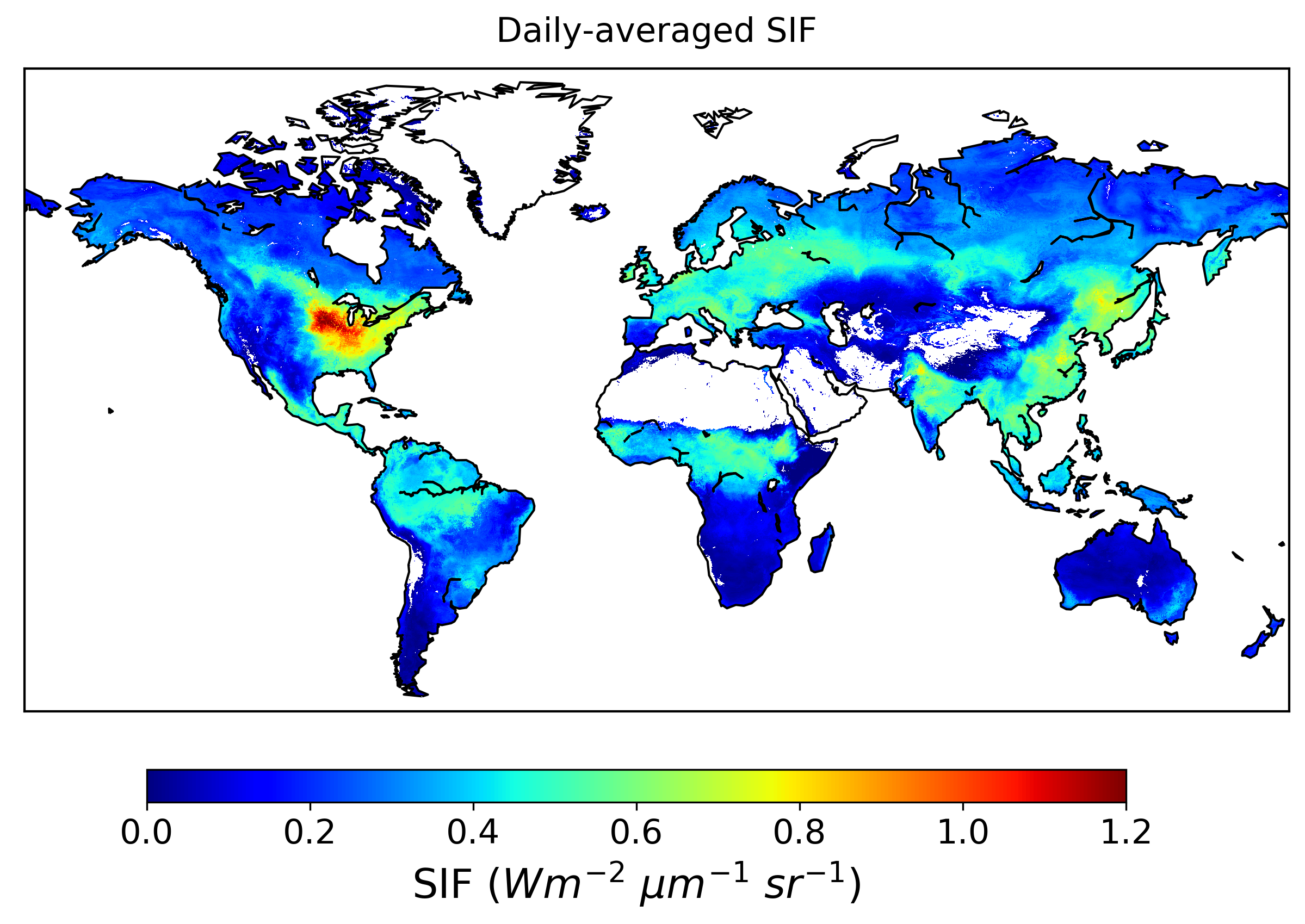
Federal
High Resolution Global Contiguous SIF Estimates from OCO-2 SIF and MODIS, Version 2
National Aeronautics and Space Administration —
This dataset provides spatially-contiguous global mean daily solar-induced chlorophyll fluorescence (SIF) estimates at 0.05 degree (approximately 5 km at the equator)... -
Federal
ECOSTRESS Evaporative Stress Index PT-JPL Daily L4 Global 70m V001
National Aeronautics and Space Administration —
The ECOsystem Spaceborne Thermal Radiometer Experiment on Space Station (ECOSTRESS) mission measures the temperature of plants to better understand how much water... -
Federal
ECOSTRESS Evaporative Stress Index dis-ALEXI Daily L4 CONUS 70 m V001
National Aeronautics and Space Administration —
The ECOsystem Spaceborne Thermal Radiometer Experiment on Space Station (ECOSTRESS) mission measures the temperature of plants to better understand how much water... -
Federal
Groundwater and Soil Moisture Conditions from GRACE and GRACE-FO Data Assimilation L4 7-days 0.125 x 0.125 degree U.S. V4.0 (GRACEDADM_CLSM0125US_7D) at GES DISC
National Aeronautics and Space Administration —
Scientists at NASA Goddard Space Flight Center generate groundwater and soil moisture drought indicators each week. They are based on terrestrial water storage... -
Federal
The effect of spaceflight on transgenic Arabidopsis plants with compromised signaling
National Aeronautics and Space Administration —
Understanding the molecular mechanisms by which plants sense and adapt to changes in the space environment is essential for generating plants that are better adapted... -
Federal
WLDAS Noah-MP 3.6 Land Surface Model L4 Daily 0.01 degree x 0.01 degree Version D1.0 (WLDAS_NOAHMP001_DA1) at GES DISC
National Aeronautics and Space Administration —
The Western Land Data Assimilation System (WLDAS), developed at Goddard Space Flight Center (GSFC) and funded by the NASA Western Water Applications Office, provides...

Official websites use .gov
A
.gov website belongs to an official government
organization in the United States.
Secure .gov websites use HTTPS
A
lock (
) or https:// means you’ve safely connected to
the .gov website. Share sensitive information only on official,
secure websites.