
-
Federal
CERES Energy Balanced and Filled (EBAF) TOA and Surface Monthly means data in netCDF Edition 4.1
National Aeronautics and Space Administration —
CERES_EBAF_Edition4.1 is the Clouds and the Earth's Radiant Energy System (CERES) Energy Balanced and Filled (EBAF) Top-of-Atmosphere (TOA) and surface monthly means... -
Federal
GPM IMERG Final Precipitation L3 1 month 0.1 degree x 0.1 degree V07 (GPM_3IMERGM) at GES DISC
National Aeronautics and Space Administration —
Version 07B is the current version of the IMERG data sets. Older versions will no longer be available and have been superseded by Version 07.The Integrated Multi-... -
Federal
NWS Daily Climatology Data: 1990 (SNF)
National Aeronautics and Space Administration —
Weather data were collected by the National Weather Service in International Falls, Minnesota. International Falls is about 80 miles from the SNF, but the weather... -
Federal
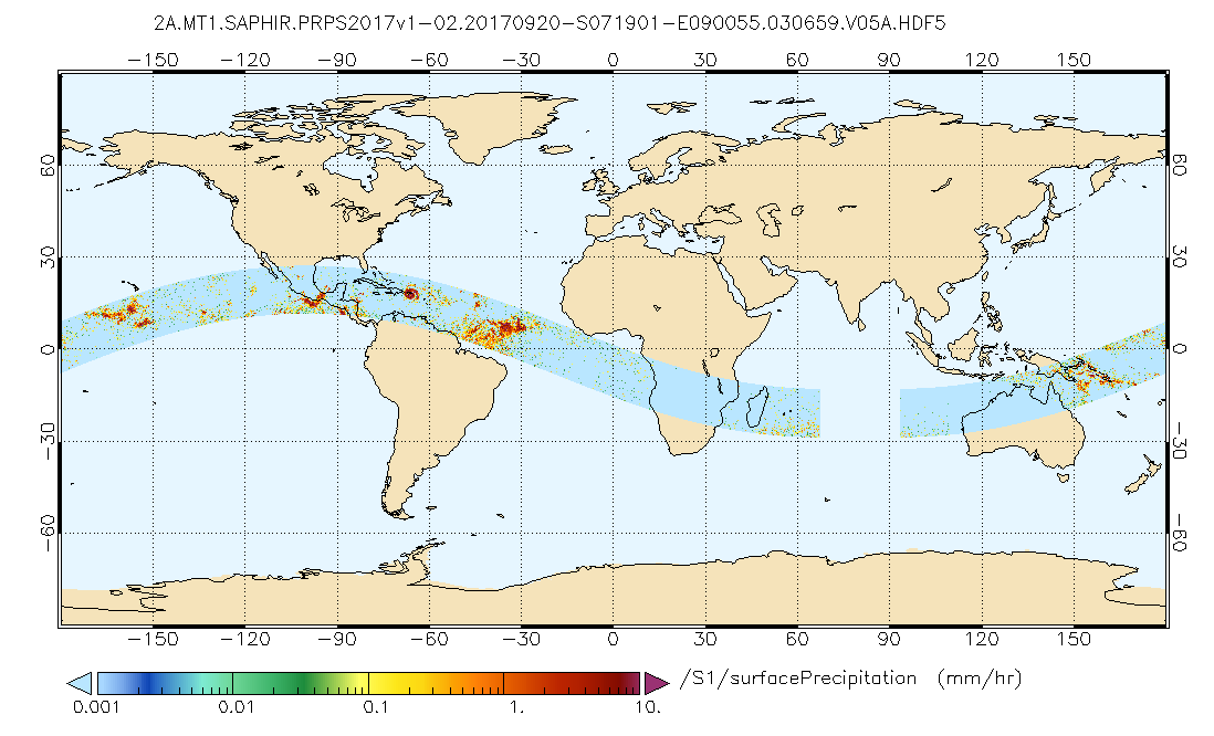
GPM SAPHIR on MT1 (PRPS) Climate-based Radiometer Precipitation Profiling L2 1.5 hours 10 km V06 (GPM_2APRPSMT1SAPHIR_CLIM) at GES DISC
National Aeronautics and Space Administration —
Version 6 is the current version of this dataset. Older versions are no longer available and have been superseded by Version 6.The Precipitation Retrieval and... -
Federal
LBA Regional Land Cover from AVHRR, 8-km, 1984 (DeFries et al.)
National Aeronautics and Space Administration —
This data set is a subset of an 8-km global land cover product (DeFries et al. 1998). This subset was created for the study area of the Large Scale Biosphere-... -
Federal
NWS Daily Climatology Data: 1975 (SNF)
National Aeronautics and Space Administration —
Weather data were collected by the National Weather Service in International Falls, Minnesota. International Falls is about 80 miles from the SNF, but the weather... -
Federal
Goddard Satellite-Based Surface Turbulent Fluxes, 1x1 deg Monthly Climatology, Set1 and NCEP V2c (GSSTFMC) at GES DISC
National Aeronautics and Space Administration —
These data are the Goddard Satellite-based Surface Turbulent Fluxes Version-2c Dataset recently produced through a MEaSURES funded project led by Dr. Chung-Lin Shie... -
Federal
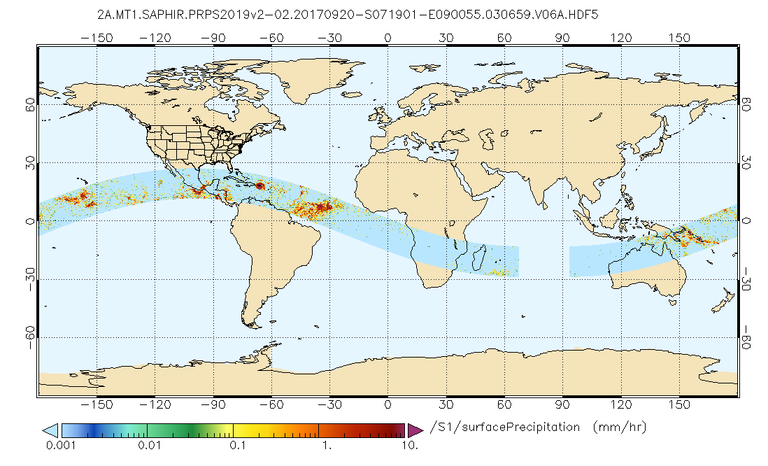
GPM SAPHIR on MT1 (PRPS) Radiometer Precipitation Profiling L2 1.5 hours 10 km V06 (GPM_2APRPSMT1SAPHIR) at GES DISC
National Aeronautics and Space Administration —
Version 6 is the current version of this dataset. Older versions are no longer available and have been superseded by Version 6.The Precipitation Retrieval and... -
Federal
LBA Regional Freshwater Wetlands, 1-Degree (Stillwell-Soller et al.)
National Aeronautics and Space Administration —
This data set consists of a subset of a 1-degree gridded global freshwater wetlands database (Stillwell-Soller et al. 1995). This subset was created for the study... -
Federal
Multi-Satellite Air Quality Sulfur Dioxide (SO2) Database Long-Term L4 Global V2 (MSAQSO2L4) at GES DISC
National Aeronautics and Space Administration —
These data are a part of Multi-Decadal Sulfur Dioxide (SO2) Climatology from Satellite Instruments (MEaSUREs-12-0022 project). Version 2 of the global catalogue of... -
Federal
LBA Regional Global Historical Climatology Network, V. 1, 1832-1990
National Aeronautics and Space Administration —
This data set consists of a subset of the Global Historical Climatology Network (GHCN) Version 1 database for the study area of the Large Scale Biosphere-Atmosphere... -
Federal
NWS Daily Climatology Data: 1979 (SNF)
National Aeronautics and Space Administration —
Weather data were collected by the National Weather Service in International Falls, Minnesota. International Falls is about 80 miles from the SNF, but the weather... -
Federal
NWS Daily Climatology Data: 1981 (SNF)
National Aeronautics and Space Administration —
Weather data were collected by the National Weather Service in International Falls, Minnesota. International Falls is about 80 miles from the SNF, but the weather... -
Federal
NWS Monthly Climatology Summary (SNF)
National Aeronautics and Space Administration —
Weather data were collected by the National Weather Service in International Falls, Minnesota. International Falls is about 80 miles from the SNF, but the weather... -
Federal
Global Monthly Climatology for the Twentieth Century (New et al.)
National Aeronautics and Space Administration —
This is a data set of mean monthly surface climate data over global land areas, excluding Antarctica, for nearly all of the twentieth century. The data set is gridded... -
Federal
LBA Regional Mean Climatology, 0.5-Deg, 1930-1960, V. 2.1 (Cramer and Leemans)
National Aeronautics and Space Administration —
This data set is a subset of Cramer and Leemans' (2001) global database of mean monthly climatology, which contains monthly averages of mean temperature, temperature... -
Federal
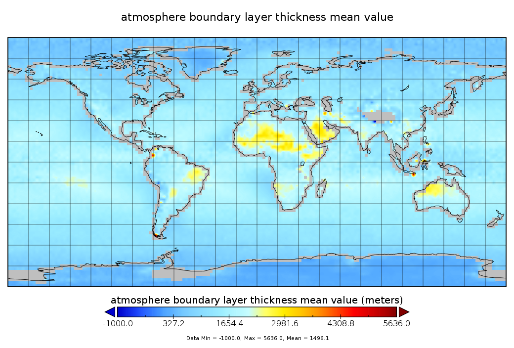
GPS Radio Occultation Boundary Layer Depth Annual L3 V2 (GPSROZPBLA) at GES DISC
National Aeronautics and Space Administration —
This dataset provides an annual average climatology of planetary boundary layer (PBL) height derived from COSMIC/FORMOSAT-3, TerraSAR-X, KOMPSAT-5, and PAZ Global... -
Federal
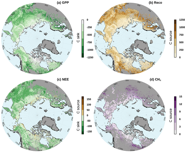
Gridded CO2 and CH4 Flux Estimates for pan-Arctic and Boreal Regions, 2003-2015
National Aeronautics and Space Administration —
This dataset provides gridded estimates of gross primary productivity (GPP), ecosystem respiration (Reco), net ecosystem CO2 exchange (NEE = Reco - GPP), and methane... -
Federal
GPM SAPHIR on MT1 (PRPS) Radiometer Precipitation Profiling L3 1 month 0.25 x 0.25 degree V06 (GPM_3PRPSMT1SAPHIR) at GES DISC
National Aeronautics and Space Administration —
Version 6 is the current version of this dataset. Older versions are no longer available and have been superseded by Version 6.The Precipitation Retrieval and...

Official websites use .gov
A
.gov website belongs to an official government
organization in the United States.
Secure .gov websites use HTTPS
A
lock (
) or https:// means you’ve safely connected to
the .gov website. Share sensitive information only on official,
secure websites.