
-
Federal
Combined GPS Broadcast Ephemeris Data (30-second sampling, hourly files) from NASA CDDIS
National Aeronautics and Space Administration —
This dataset consists of ground-based Global Navigation Satellite System (GNSS) Combined Broadcast Ephemeris Data (hourly files of all distinct navigation messages... -
Federal
SOLVE I DC-8 Analysis Model Data
National Aeronautics and Space Administration —
SOLVE1_Analysis_DC8_Data contains modeled trajectories and meteorological data along the flight path for the DC-8 aircraft collected during the SAGE III Ozone Loss... -
Federal
CALIPSO Lidar Level 1.5 Profile, V1-01
National Aeronautics and Space Administration —
CAL_LID_L15-Standard-V1-01 is the Cloud-Aerosol Lidar and Infrared Pathfinder Satellite Observations (CALIPSO) Lidar Level 1.5 Profile, Version 1-01 data product.... -
Federal
Earth Radiation Budget Experiment (ERBE) Regional, Zonal, and Global Averages S-4 data in native format
National Aeronautics and Space Administration —
ERBE_S4_NAT_1 is the Earth Radiation Budget Experiment (ERBE) Regional, Zonal, and Global Averages S-4 data in native format data set, which contains space and time... -
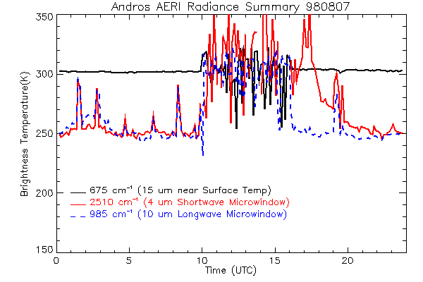
Federal
CAMEX-3 ATMOSPHERIC EMITTED RADIANCE INTERFEROMETER (AERI) V1
National Aeronautics and Space Administration —
The Atmospheric Emitted Radiance Interferometer (AERI) was used to make atmospheric temperature and moisture retrievals. AERI provides absolutely calibrated radiances... -
Federal
Global Soil Types, 0.5-Degree Grid (Modified Zobler)
National Aeronautics and Space Administration —
A global data set of soil types is available at 0.5-degree latitude by 0.5-degree longitude resolution. There are 106 soil units, based on Zobler?s (1986) assessment... -
Federal
Ground-Based Global Navigation Satellite System (GNSS) Quasi-Zenith Satellite System (QZSS) Broadcast Ephemeris Data (30-second sampling, hourly files) from NASA CDDIS
National Aeronautics and Space Administration —
This dataset consists of ground-based Global Navigation Satellite System (GNSS) Quasi-Zenith Satellite System (QZSS) Broadcast Ephemeris Data (hourly files) from the... -
Federal
SatCORPS CERES GEO Edition 4 GOES-18 Northern Hemisphere Version 1.2
National Aeronautics and Space Administration —
CER_GEO_Ed4_GOE18_NH_V01.2 is the Satellite Cloud and Radiation Property retrieval System (SatCORPS) Clouds and the Earth's Radiant Energy System (CERES)... -
Federal
Aircraft Flux-Filtered: U of Wy. (FIFE)
National Aeronautics and Space Administration —
The University of Wyoming (UW) King Air atmospheric boundary layer measurement missions were flown in 1987 during IFCs 3 and 4. This Boundary Layer Fluxes data set... -
Federal
DISCOVER-AQ Maryland Deployment NOAA Delaware II Ship Data
National Aeronautics and Space Administration —
DISCOVERAQ_Maryland_Ship_NOAA-DelawareII_Data contains data collected onboard the NOAA Delaware II Ship during the Maryland (Baltimore-Washington) deployment of... -
Federal
Global Navigation Satellite System (GNSS) IGS Final Combined Orbit Solution Summary Product from NASA CDDIS
National Aeronautics and Space Administration —
This derived product set consists of Global Navigation Satellite System Final Orbit/Reference Frame Product Summary from the NASA Crustal Dynamics Data Information... -
Federal
First ISCCP Regional Experiment (FIRE) Atlantic Stratocumulus Transition Experiment (ASTEX) Malcolm Baldridge Radiosonde Data
National Aeronautics and Space Administration —
The First ISCCP Regional Experiments have been designed to improve data products and cloud/radiation parameterizations used in general circulation models (GCMs).... -
Federal
ORACLES Aerosol Aircraft InSitu Data
National Aeronautics and Space Administration —
ORACLES_Aerosol_AircraftInSitu_Data are in situ aerosol measurements collected onboard the P-3 Orion or ER-2 aircraft during the ObseRvations of Aerosols above CLouds... -
Federal
Dynamics and Chemistry of the Summer Stratosphere Airborne Data Products
National Aeronautics and Space Administration —
DCOTSS-Aircraft-Data features the aircraft data collected during the Dynamics and Chemistry of the Summer Stratosphere sub-orbital campaign. These data products were... -
Federal
TEMPO gridded formaldehyde total column V03 (PROVISIONAL)
National Aeronautics and Space Administration —
Formaldehyde Level 3 files provide trace gas information on a regular grid covering the TEMPO field of regard for nominal TEMPO observations. Level 3 files are... -
Federal
GEWEX SRB Integrated Product (Rel-4) Shortwave Monthly Average by UTC Fluxes
National Aeronautics and Space Administration —
GEWEXSRB_Rel4-IP_Shortwave_monthly_utc is the Global Energy and Water Exchanges (GEWEX) Surface Radiation Budget (SRB) Integrated Product (Rel-4) Shortwave Monthly... -
Federal
Western North American FLEXPART Back Trajectory 2008 Data
National Aeronautics and Space Administration —
WNA-FLEXPART-BackTraj-2008 is the 2008 Western North America Back Trajectory data using the FLEXible PARTicle (FLEXPART) dispersion model. Data collection for this... -
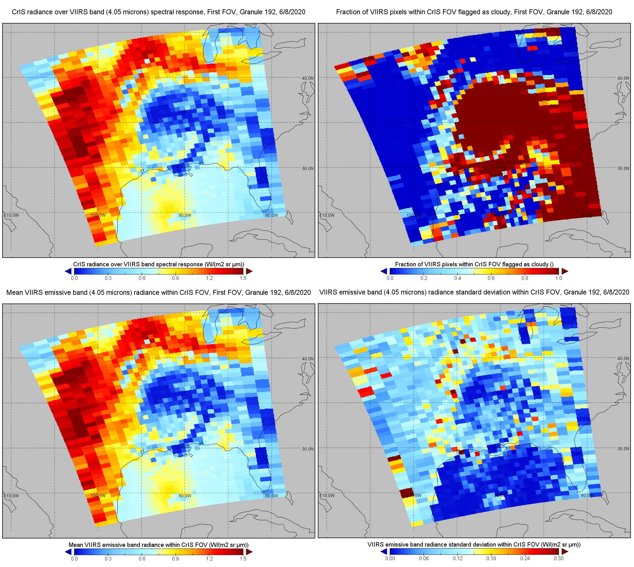
Federal
S-NPP CrIS IMG: Collocated VIIRS level 1 / cloud mask statistical summary V2 (SNDRSNCrISL1BIMG) at GES DISC
National Aeronautics and Space Administration —
The Cross-track Infrared Sounder (CrIS) Level 1B Normal Spectral Resolution (NSR) data files contain radiance measurements along with ancillary spacecraft,... -
Federal
Process-structure-properties investigations for laser powder bed fused IN718 in the as-built condition
National Institute of Standards and Technology —
This data repository provides a central location for a body of work using one build of nickel-based alloy 718 (IN718) material and resulted in three different... -
Federal
ACEPOL High Spectral Resolution Lidar 2 (HSRL-2) Remotely Sensed Data
National Aeronautics and Space Administration —
ACEPOL High Spectral Resolution Lidar 2 (HSRL-2) Remotely Sensed Data (ACEPOL_AircraftRemoteSensing_HSRL2_Data) are remotely sensed measurements collected by the...

Official websites use .gov
A
.gov website belongs to an official government
organization in the United States.
Secure .gov websites use HTTPS
A
lock (
) or https:// means you’ve safely connected to
the .gov website. Share sensitive information only on official,
secure websites.