
-
Federal
GEDI L2A Elevation and Height Metrics Data Global Footprint Level V002
National Aeronautics and Space Administration —
The Global Ecosystem Dynamics Investigation (GEDI) mission aims to characterize ecosystem structure and dynamics to enable radically improved quantification and... -
Federal
South Florida Marine Biodiversity Observation Network (SFMBON)
National Aeronautics and Space Administration —
The South Florida Marine Biodiversity Observation Network (SFMBON) build on the foundations laid by the present Sanctuaries MBON demonstration. A close partnership... -
Federal
GEDI L1B Geolocated Waveform Data Global Footprint Level V001
National Aeronautics and Space Administration —
GEDI Version 1 data products were decommissioned on February 15, 2022. Users are advised to use the improved GEDI01_B Version 2 data product.The Global Ecosystem... -
Federal
GEDI L2A Elevation and Height Metrics Data Global Footprint Level V001
National Aeronautics and Space Administration —
GEDI Version 1 data products were decommissioned on February 15, 2022. Users are advised to use the improved GEDI02_A Version 2 data product.The Global Ecosystem... -
Federal
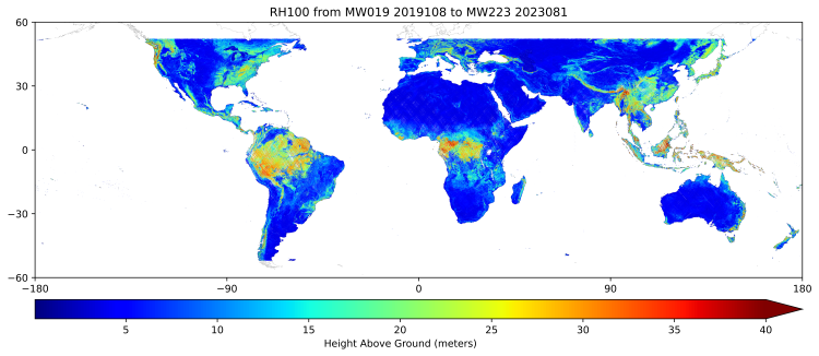
GEDI L3 Gridded Land Surface Metrics, Version 1
National Aeronautics and Space Administration —
This dataset provides Global Ecosystem Dynamics Investigation (GEDI) Level 3 (L3) gridded mean canopy height, standard deviation of canopy height, mean ground... -
Federal
GEDI L2B Canopy Cover and Vertical Profile Metrics Data Global Footprint Level V001
National Aeronautics and Space Administration —
GEDI Version 1 data products were decommissioned on February 15, 2022. Users are advised to use the improved GEDI02_B Version 2... -
Federal
Gridded GEDI Vegetation Structure Metrics and Biomass Density at Multiple Resolutions
National Aeronautics and Space Administration —
This dataset consists of near-global, analysis-ready, multi-resolution gridded vegetation structure metrics derived from NASA Global Ecosystem Dynamics Investigation... -
Federal
Marine Biodiversity Observation Network (MBON)
National Aeronautics and Space Administration —
The Marine Biodiversity Observation Network (MBON) is a growing global initiative composed of regional networks of scientists, resource managers, and end-users... -
Federal
Airborne Hyperspectral Reflectance LTER Cedar Creek Minnesota Daily 300 mm
National Aeronautics and Space Administration —
The Airborne Hyperspectral Reflectance image mosaic is of the Long-Term Ecological Research (LTER) site at Cedar Creek Ecosystem Science Reserve (CCESR), Minnesota... -
Federal
Biodiversity Survey of the Cape - Mapping Dissolved Organic Carbon sources and cycling in aquatic biodiversity hotspots across South Africa's Greater Cape Floristic Region
National Aeronautics and Space Administration —
This dataset includes the spectral (absorption and fluorescence) characteristics of colored dissolved organic matter (CDOM) coincident with field measurements of... -
Federal
Airborne Hyperspectral Reflectance Wood River Nebraska Multi-Day 1 m
National Aeronautics and Space Administration —
The Airborne Hyperspectral Reflectance image mosaic is of the long-term prairie restoration and biodiversity study site led by the Nature Conservancy near Wood River,... -
Federal
Regridded Harmonized World Soil Database v1.2
National Aeronautics and Space Administration —
This data set describes select global soil parameters from the Harmonized World Soil Database (HWSD) v1.2, including additional calculated parameters such as area... -
Federal
Tara Oceans Expedition
National Aeronautics and Space Administration —
The Tara Oceans expedition, a 2.5-year long and 57,000 mile long trajectory, was conceived to provide a snapshot of the distribution of planktonic organisms in the... -
Federal
TARA-EUROPA
National Aeronautics and Space Administration —
For two consecutive years (2023-2024), the schooner Tara is participating in the study of coastal ecosystems all along the European coast. The sampling of Tara Europa... -
Federal
Tara Mediterranean Expedition in 2014
National Aeronautics and Space Administration —
Over the past decades, the proliferation of plastics has rapidly become a global problem affecting all oceans. With 80% of plastics in the sea originating from land,... -
Federal
Airborne Hyperspectral Reflectance Indian Cave Nebraska Multi-Day 1 m
National Aeronautics and Space Administration —
The Airborne Hyperspectral Reflectance Indian Cave Nebraska Multi-Day (AEHYPICNE1M) data are from the Indian Cave Forest Global Earth Observatory (ForestGeo) plot in... -
Federal
GEDI L3 Gridded Land Surface Metrics, Version 2
National Aeronautics and Space Administration —
This dataset provides Global Ecosystem Dynamics Investigation (GEDI) Level 3 (L3) gridded mean canopy height, standard deviation of canopy height, mean ground...

Official websites use .gov
A
.gov website belongs to an official government
organization in the United States.
Secure .gov websites use HTTPS
A
lock (
) or https:// means you’ve safely connected to
the .gov website. Share sensitive information only on official,
secure websites.