
-
Federal
2024 NOAA NGS Emergency Response Imagery: Hurricane Helene
National Oceanic and Atmospheric Administration, Department of Commerce —
Aerial imagery was acquired following Hurricane Helene. The aerial photography missions were conducted by the NOAA Remote Sensing Division. The images were acquired... -
Federal
Hui O Ka Wai Ola Water Quality Data
National Oceanic and Atmospheric Administration, Department of Commerce —
The goal of the Hui O Ka Wai Ola (Association Of The Living Waters) citizen-science based water quality program is to increase the capacity for monitoring water... -
Federal
NOAA Environmental Sensitivity Index (ESI) maps and geographic information systems data from 1900 to 2009
National Oceanic and Atmospheric Administration, Department of Commerce —
This collection comprises the Environmental Sensitivity Index (ESI) data for various regions in U.S. coastal waters. ESI data characterize estuarine environments and... -
Federal
Hawaii Clean Water Branch (CWB) Beach Water Quality Data
National Oceanic and Atmospheric Administration, Department of Commerce —
Exposure to sewage contaminated recreational waters may cause gastrointestinal illnesses in swimmers. The State of Hawaii Department of Health (HIDOH) Clean Water... -
Federal
H12527: NOS Hydrographic Survey , 2013-06-12
National Oceanic and Atmospheric Administration, Department of Commerce —
The National Oceanic and Atmospheric Administration (NOAA) has the statutory mandate to collect hydrographic data in support of nautical chart compilation for safe... -
Federal
2025 NOAA NGS Ortho-rectified 4 band Mosaic of Bangor, Bremerton, Keyport and Manchester, WA
National Oceanic and Atmospheric Administration, Department of Commerce —
This data set contains 4-band ortho-rectified mosaic tiles, created as a product from the NOAA Integrated Ocean and Coastal Mapping (IOCM) initiative. The source... -
Federal
NOAA Office for Coastal Management Coastal Inundation Digital Elevation Model: Florida, SE
National Oceanic and Atmospheric Administration, Department of Commerce —
These data were created as part of the National Oceanic and Atmospheric Administration Office for Coastal Management's efforts to create an online mapping viewer... -
Federal
2018-2019 NOAA NGS Topobathy Lidar DEM Hurricane Irma Delivery 1: Miami to Key Largo, FL
National Oceanic and Atmospheric Administration, Department of Commerce —
The NOAA Hurricane Irma Florida Keys Topobathymetric LiDAR Delivery 1 area data were collected by Quantum Spatial, Inc. (QSI) using three Riegl systems: a Riegl... -
Federal
F00247: NOS Hydrographic Survey , Atlantic Beach, North Carolina, 1983-06-01
National Oceanic and Atmospheric Administration, Department of Commerce —
The National Oceanic and Atmospheric Administration (NOAA) has the statutory mandate to collect hydrographic data in support of nautical chart compilation for safe... -
Federal
H04968: NOS Hydrographic Survey , 1929-12-31
National Oceanic and Atmospheric Administration, Department of Commerce —
The National Oceanic and Atmospheric Administration (NOAA) has the statutory mandate to collect hydrographic data in support of nautical chart compilation for safe... -
Federal
2022 NOAA NGS Ortho-rectified 4-band Mosaic of Two Harbors to Outer Island, WI
National Oceanic and Atmospheric Administration, Department of Commerce —
This data set contains 4-band ortho-rectified mosaic tiles, created as a product from the NOAA Integrated Ocean and Coastal Mapping (IOCM) initiative. The source... -
Federal
2014 NOAA NGS Ortho-rectified MLLW Near-Infrared Mosaic of Puget Sound - Everett to Spring Beach, WA
National Oceanic and Atmospheric Administration, Department of Commerce —
This data set contains ortho-rectified mosaic tiles, created as a product from the NOAA Integrated Ocean and Coastal Mapping (IOCM) initiative. The source imagery was... -
Federal
Shoreline Mapping Program of ROBINS NECK TO BUCKROE BEACH, VA, VA0501D NGDA
National Oceanic and Atmospheric Administration, Department of Commerce —
These data provide an accurate high-resolution shoreline compiled from imagery of ROBINS NECK TO BUCKROE BEACH, VA . This vector shoreline data is based on an office... -
Federal
2017 NOAA/MCP Topobathy Lidar: Blue Hill Bay, ME - Riegl Sensor
National Oceanic and Atmospheric Administration, Department of Commerce —
Fugro was contracted in July 2017 by the State of Maine Department of Marine Resources (SMDMR), Maine Coastal Program (MCP), and the NOAA Office for Coastal... -
Federal
NEOWAVE Regional Tsunami Model: Kalapana 1975: Hawaii: Hawaii Island: South Point
National Oceanic and Atmospheric Administration, Department of Commerce —
Non-hydrostatic Evolution of Ocean WAVEs (NEOWAVE) regional tsunami model for the southern point of Hawaii Island in the State of Hawaii, stretching from beyond... -
Federal
NEOWAVE Regional Tsunami Model: South Hawaii PMT: Hawaii: Hawaii Island: Punaluu
National Oceanic and Atmospheric Administration, Department of Commerce —
Non-hydrostatic Evolution of Ocean WAVEs (NEOWAVE) regional tsunami model for the south-southeast coast of Hawaii Island in the State of Hawaii, stretching from... -
Federal
F00484: NOS Hydrographic Survey , Chart Investigations: Ports of Los Angeles and Long Beach, California, 2002-04-26
National Oceanic and Atmospheric Administration, Department of Commerce —
The National Oceanic and Atmospheric Administration (NOAA) has the statutory mandate to collect hydrographic data in support of nautical chart compilation for safe... -
Federal
H00116A: NOS Hydrographic Survey , 1843-12-31
National Oceanic and Atmospheric Administration, Department of Commerce —
The National Oceanic and Atmospheric Administration (NOAA) has the statutory mandate to collect hydrographic data in support of nautical chart compilation for safe... -
Federal
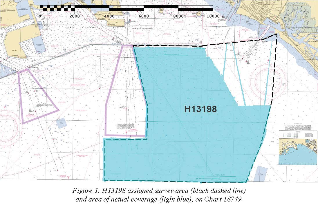
H13198: NOS Hydrographic Survey , 2018-10-29
National Oceanic and Atmospheric Administration, Department of Commerce —
The National Oceanic and Atmospheric Administration (NOAA) has the statutory mandate to collect hydrographic data in support of nautical chart compilation for safe... -
Federal
H13197: NOS Hydrographic Survey , 2018-10-29
National Oceanic and Atmospheric Administration, Department of Commerce —
The National Oceanic and Atmospheric Administration (NOAA) has the statutory mandate to collect hydrographic data in support of nautical chart compilation for safe...

Official websites use .gov
A
.gov website belongs to an official government
organization in the United States.
Secure .gov websites use HTTPS
A
lock (
) or https:// means you’ve safely connected to
the .gov website. Share sensitive information only on official,
secure websites.
.jpg)
.jpg)